Locus Fast and useful Online/Offline map viewer for Android.
· This is also My Maps editor so Google Account permission is needed
· Contacts permission is for getting contact address on various places in app (adding point into database by contact address, etc...)
· If anything not work, send email
· If app crash, send log from logcat or Locus/logs directory
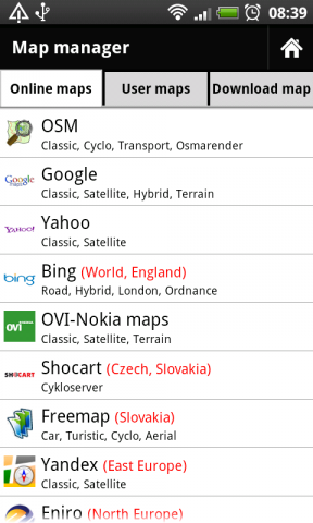
· Online maps (OSM, Google, Yahoo, Bing, OVI/Nokia, ... actually 37 types)
· Offline maps (SQLiteDB format, updated TrekBuddy TARed format)
· direct download Online -> Offline (defined area - rectangle, path, state).
· Google My Maps Viewer, Google My Maps editor (BETA)!
· POI handling => POI import into separated categories, viewing on map, basic guiding.
· support for Groundspeak PocketQuery
· Google Street View
· support for Bluetooth GPS
· work with c:geo, GPS Status
· quick and clean GUI
· and more
What's New in This Release:
· fixed some language troubles (import/export)
· full support for zipped files import
· better support for GPX files
· faster data importing
What's New in 0.9.21:
· fixed problem with adding categories
· rewrote a little start of app
What's New in 0.9.15:
· distance on screen during path creating
· improved handling with track styles. Now define style for import and record separately
· bug fixes
Like it? Share with your friends!
Supported operating systems:
Google Android 1.6, Google Android 10.x, Google Android 2.0, Google Android 2.1, Google Android 2.2, Google Android 2.3, Google Android 3.0, Google Android 3.1, Google Android 3.2, Google Android 4.0, Google Android 4.1, Google Android 4.2, Google Android 4.3, Google Android 4.4, Google Android 5.x, Google Android 6.x, Google Android 7.x, Google Android 8.x, Google Android 9.x
Similar Software:
MapMakr MapMakr If you’re an aid worker responding to a humanitarian crisis, up to date, accurate, and easy to read maps are vital. Knowing whether a bridge has collapsed, a road is passable and where you can land planes bringing in aid is really important
OS Map OS Map is a tool to turn your Android phone into a handy Ordnance Survey map, with your GPS position pinpointed on it!
· Nearly all OS Map scales available (including 250,000 and 50,000).
· Touch-scrolling - simply use your finger to drag the map around.
· Fast resume from standby and fast position updates
amAze GPS light edition amAze GPS light edition provides access to worldwide street maps, full topographic map coverage of the USA and satellite imagery for 200 major cities around the world. It allows you to search in a worldwide rich POI database and you can upgrade to the full version that includes turn-by-turn voice guided navigation from within the application
Las Vegas DK Eyewitness Top 10 Travel Guide & Map (BlackBerry) Las Vegas DK Eyewitness Top 10 Travel Guide & Map(BlackBerry)- Save time, discover the 10 best of everything to see, buy, taste AND avoid in the Sin City Las Vegas. Plus easily make your way through the city with the included maps
World Map 2011 FREE World Map 2011 FREE - World Map
*** NEW RELEASE ***
View a large quick reference World Map on your Android today!
Contains Up-To-Date World Maps!
Did you know?
-------------
South Sudan became the world's 195th country following separation from Sudan on 9 July 2011
Features
---------
- Political World Map
- No internet connection is required
CoPilot Live Premium UK + IRE (Android) CoPilot Live Premium UK + IRE (Android) - Now there’s a better way to navigate.
CoPilot Live Premium is the essential voice-guided sat navigation app to get you where you need to go, by the way that suits you best.
Detailed street maps of one single European region (e.g
Street View on Google Maps Street View on Google Maps - New! Street View smart navigation -- move around by dragging "Pegman" where you want to go. Try Street View on Google Maps to view street-level imagery from your phone. To use Street View, open Google Maps, search for a place or long-press the map, and tap the Street View option
Wi-Fi Map Maker - Free Wi-Fi Map Maker is application makes a map of Wi-Fi access points as you walk around.
· Maps out the actual coverage of each access point!
· Access point names are displayed on the map
· See street address and area of access points
· You can select the criteria for inclusion on your map
MapDroyd MapDroyd - Of course, today there are many Android application featuring street maps. Most of them are based on Google Maps, which means you've to enable your mobile device's network connection through a GPRS or Wifi connection
CoPilot Live UK + Ireland (Android) CoPilot Live UK + Ireland (Android) - CoPilot Live is full-featured voice-guided GPS navigation with street maps of 1 European region stored on your Android phone. Includes 3D guidance, lane assist, speed limit warnings, safety camera alerts, planning mode.
Download maps via WiFi after purchase. Unlimited use after 10 days once Google order verified
Other Software by developer «menion»:
Locus Free Locus Free - Fast and useful Online/Offline map viewer for Android.
· This is also My Maps editor so Google Account permission is needed
· Contacts permission is for getting contact address on various places in app (adding point into database by contact address, etc..


")

")


")
