Locus Fast and useful Online/Offline map viewer for Android.
· This is also My Maps editor so Google Account permission is needed
· Contacts permission is for getting contact address on various places in app (adding point into database by contact address, etc...)
· If anything not work, send email
· If app crash, send log from logcat or Locus/logs directory
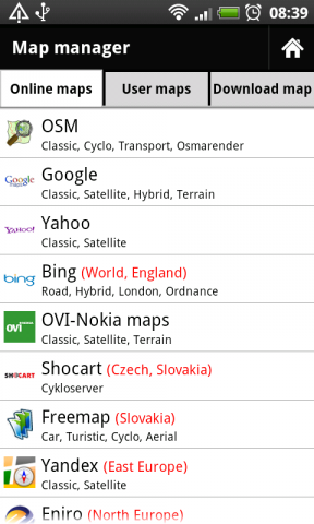
· Online maps (OSM, Google, Yahoo, Bing, OVI/Nokia, ... actually 37 types)
· Offline maps (SQLiteDB format, updated TrekBuddy TARed format)
· direct download Online -> Offline (defined area - rectangle, path, state).
· Google My Maps Viewer, Google My Maps editor (BETA)!
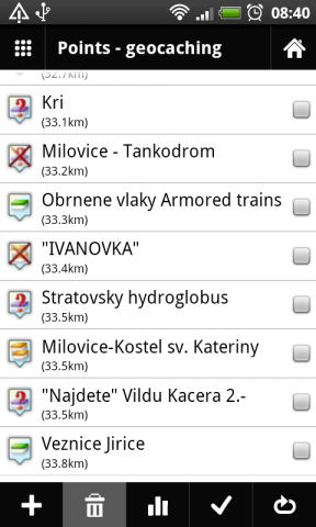
· POI handling => POI import into separated categories, viewing on map, basic guiding.
· support for Groundspeak PocketQuery
· Google Street View
· support for Bluetooth GPS
· work with c:geo, GPS Status
· quick and clean GUI
· and more
What's New in This Release:
· fixed some language troubles (import/export)
· full support for zipped files import
· better support for GPX files
· faster data importing
What's New in 0.9.21:
· fixed problem with adding categories
· rewrote a little start of app
What's New in 0.9.15:
· distance on screen during path creating
· improved handling with track styles. Now define style for import and record separately
· bug fixes
Like it? Share with your friends!
Supported operating systems:
Google Android 1.6, Google Android 10.x, Google Android 2.0, Google Android 2.1, Google Android 2.2, Google Android 2.3, Google Android 3.0, Google Android 3.1, Google Android 3.2, Google Android 4.0, Google Android 4.1, Google Android 4.2, Google Android 4.3, Google Android 4.4, Google Android 5.x, Google Android 6.x, Google Android 7.x, Google Android 8.x, Google Android 9.x
Similar Software:
zhiing zhiing connects people-to-people, people-to-places and people-to-services with dynamic maps and turn-by-turn driving directions. Forget about map printouts or scribbling down directions....use zhiing! Simply enter the mobile number you want to zhiing and hit send
AugSatNav Walk AugSatNav is an augmented reality navigation system which overlays walking directions upon a live video feed of the path or road ahead.
With AugSatNav there is no need to follow instructions or interpret maps - you can simply find your way by walking along the route highlighted by a bright white line
Gowalla Gowalla is the easiest way to share places you go with friends. Download the app to discover eateries, coffeehouses, hotspots, hangouts, shops, landmarks, parks, museums and more. Share your experiences through Gowalla with friends on Facebook and Twitter, then stamp your passport to earn rewards at the places you visit
Cell Phone Coverage Map Cell Phone Coverage Map - Test your mobile service for yourself and compare results to other carriers using RootMetrics. Coverage information in the market today is incomplete and gathered infrequently - often no more than once a year - resulting in soft advertising claims of network reliability. RootMetrics is different
Latitude Launcher Latitude isn't enabled in the UK, and some other countries, on the T-Mobile G1, however it is enabled on many other phones e.g. Nokia N95. This is frustrating, a Google phone without Google Latitude.
Latitude Launcher can enable Latitude for you if you have 'Rooted' your phone
Modern Compass Modern Compass this compass does what the compass always was intended to do, it helps you locate the destination of your choice.
Using GPS technology and Google maps, this application lets you mark a destination of choice and then shows in what direction that destination lies, as well as how far away it is from your current location
TrekBuddy Trekbuddy is a J2ME application to be used with a GPS receiver. It is designed to work with every Java-enabled device. It features capabilities such as: * GPS tracking and simple navigation * bitmap maps (without zoom, you can store bitmap maps with different resolution instead)
GoPenS GoPenS is an OpenSource GPS application for Android phones, based on OpenStreetMap (OSM). OpenStreetMap is a collaborative map of the world. Therefore, one of the main functions of the application is to be able to record a trace and send it as a GPX to the OSM servers, and so edit the OSM Map
amAze (Sony Ericsson) AmAze is a first of its kind free navigation and local search service. It is free to download and use and it contains wide coverage of maps including aerial photo in Europe, North America, Australia and parts of Asia and Africa
amAze (Motorola) AmAze is a first of its kind free navigation and local search service. It is free to download and use and it contains wide coverage of maps including aerial photo in Europe, North America, Australia and parts of Asia and Africa
Other Software by developer «menion»:
Locus Free Locus Free - Fast and useful Online/Offline map viewer for Android.
· This is also My Maps editor so Google Account permission is needed
· Contacts permission is for getting contact address on various places in app (adding point into database by contact address, etc..


_13333small.png "Gowalla")


")
")
