HERE WeGo - will always help you find the needed way in the city. The application will offer the best routes for any mode of transport or for going on foot. This utility will take you to the destination point with the help of voice messages and will inform you about extra ways in case of change on the road.
Game features:
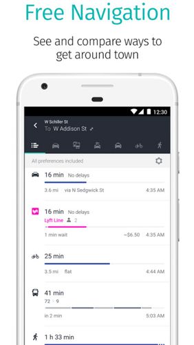
Big choice of transport
Comparison of routes
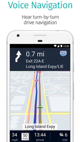
Voice and visual instructions
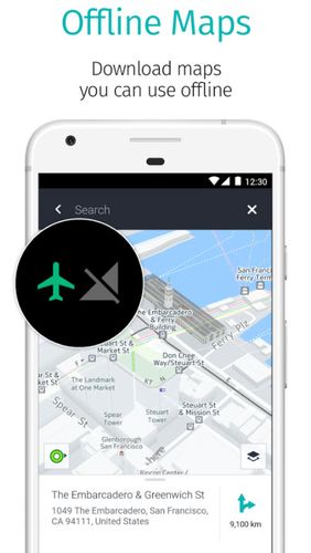
Offline maps
Like it? Share with your friends!
Supported operating systems:
Google Android 10.x, Google Android 4.1, Google Android 4.2, Google Android 4.3, Google Android 4.4, Google Android 5.x, Google Android 6.x, Google Android 7.x, Google Android 8.x, Google Android 9.x
Similar Software:
jetBlue Get jetBlue on your cell phone or PDA and you'll get instant access to flight status information, weather alerts and even our inflight entertainment and snacks. Take jetBlue wherever you go!
e-Mobile family locator e-Mobile family locator - Easily find friends and family by sending a text message from your phone or web.
Locate device and people
* Locate people and lost device by sending a "locate" text message.
* Generate a ringtone on missing device by sending a "ping" text message
Naver Maps Naver Maps - Smarter than ever! Experience Naver Map for Android. You can find the shortest way to get to your destination, using public transportation even it is far away. You can also search the information on the area around you easily and check whether you are heading to your destination correctly with GPS and compass
Trip Journal Lite Trip Journal Lite is the ultimate trip tracking, recording, documenting and sharing solution that is currently available for Android phones
amAze (Samsung) AmAze is a first of its kind free navigation and local search service. It is free to download and use and it contains wide coverage of maps including aerial photo in Europe, North America, Australia and parts of Asia and Africa
Street View on Google Maps Street View on Google Maps - New! Street View smart navigation -- move around by dragging "Pegman" where you want to go. Try Street View on Google Maps to view street-level imagery from your phone. To use Street View, open Google Maps, search for a place or long-press the map, and tap the Street View option
ShareYourDrive ShareYourDrive Transportation and cars especially are contaminating. Imagine with a few clicks, you can know who can give you a ride. The time real geolocalisation to save environment. Don't be afraid about security. Historic helps to know who was with you, when and where. Moreover you can give a rate to the persons you meet
Navigator Navigator - detailed maps with the support of satellite navigation. You need to specify two points to make a route. You can track your current location and set those coordinates as the route start. Thanks to marks on the map you can easily find a fuel station, restaurant or hotel
amAze (LG) AmAze is a first of its kind free navigation and local search service. It is free to download and use and it contains wide coverage of maps including aerial photo in Europe, North America, Australia and parts of Asia and Africa
TTC Subway Rider Efficiency Guide TTC Subway Rider Efficiency Guide - This application has maps of all TTC (Toronto Transit Commission) subway stations so you can see where the stairs/etc are... and plan where to stand on the platform.
Based on ttcrider.ca
Useful for handicapped people too
Comments on HERE WeGo - Offline maps & GPS:
Comments not found
If you noted an error or download link is broken, please, report it via this page or use comments.
HERE WeGo - Offline maps & GPS is compatible with your device Alcatel LX LTE NA / TracFone LX (TCL A502DL)

")


")


")
