Metro LX is a comprehensive guide to the Lisbon Subway providing:
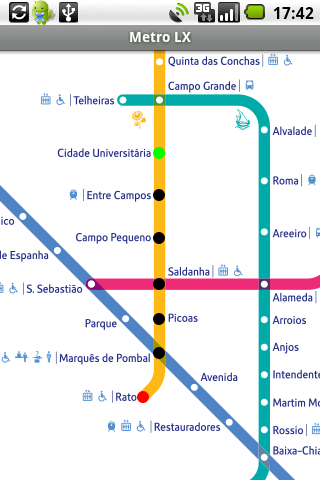
A map of Lisbon Metro (subway) in landscape and portrait modes;
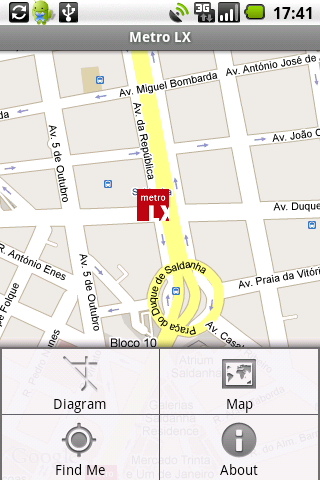
A route planner between stations;
A map route to station from your position;
And detailed information per Station.
What's New in This Release:
· Updated tariff (February 2012);
· Minor bugs fixed on tablets.
What's New in 2.8:
· Improved route to station planner;
· Updated tariff (August 2011);
· 3 new translations (Korean, Chinese and Romanian);
· Minor bugs fixed.
What's New in 2.6:
· Added preferences panel to disable/enable the use of GPS current location;
· Switch orientation crashes fixed.
What's New in 2.4:
· Minor bugs solved.
What's New in 2.3:
· Support for multiple screen sizes and resolutions.
· Layouts slightly restyled.
Like it? Share with your friends!
Supported operating systems:
Google Android 1.5, Google Android 1.6, Google Android 10.x, Google Android 2.0, Google Android 2.1, Google Android 2.2, Google Android 2.3, Google Android 3.0, Google Android 3.1, Google Android 3.2, Google Android 4.0, Google Android 4.1, Google Android 4.2, Google Android 4.3, Google Android 4.4, Google Android 5.x, Google Android 6.x, Google Android 7.x, Google Android 8.x, Google Android 9.x
Similar Software:
Hollywood Star Maps Hollywood Star Maps - Welcome to Hollywood, California - Home of the world''s greatest stars! Search and find famous celebrity homes and locations in Los Angeles, California and make your next sightseeing tour all the more fun by driving yourself to the homes of the stars
Art Places Art Places is a software application for the Android mobile operating system.
The application gets our position through the GPS in the mobile device and shows us our current location in the maps application. of maps
Locus Free Locus Free - Fast and useful Online/Offline map viewer for Android.
· This is also My Maps editor so Google Account permission is needed
· Contacts permission is for getting contact address on various places in app (adding point into database by contact address, etc..
MAPS.ME for Android MAPS.ME for Android - MapsWithMe allows you to access maps of all the countries in the world while on the go. The maps are based on OpenStreetMap data and work completely offline, without requiring an internet connection
Outdoor Offline Maps for Android Outdoor Offline Maps for Android - The Outdoor Navigation software is your best friend through your adventures in the wild.
Go into the outdoors with confidence and enjoy your activities without worrying about the tools to help you navigate. Your Outdoor Navigation app is made by the people who have been developing this software since 2003 across multiple platforms
TripComputer TripComputer is a personal off-road GPS navigation utility software for Android phones, that has been created for active people, who love travel by hike or bike.
The application does not use Internet connection or Google Maps for navigation or track recording, but you can share your data to others, or store your data on server
Mobilex GPS Logger Mobilex GPS Logger - Overview ========================== The Android GPS Logger application captures GPS updates, and saves latitude and longitude coordinate fixes to text files on micro SD card. Supported Features inlcude: ============================== Google Maps. Satellite, Traffic and Street Views
NAVIGON MobileNavigator NAVIGON MobileNavigator - Turn your Android phone into a mobile navigation device with lots of useful functions that will delight you! The pocket navigation device will show you the right way with functions such as Reality View Pro and Lane Assistant Pro
AugSatNav Walk AugSatNav is an augmented reality navigation system which overlays walking directions upon a live video feed of the path or road ahead.
With AugSatNav there is no need to follow instructions or interpret maps - you can simply find your way by walking along the route highlighted by a bright white line
OSMTracker for Android OSMTracker stands for OpenStreetMap Tracker. It allows you to track your journey and mark significant way points. Way points can be marked with a tag using a button, with a quick voice record, a text note or by taking a picture. The various button pages and layouts can be customized to suit your OpenStreetMap activities
Other Software by developer «DFX»:
not found
Comments on Metro LX:
Comments not found
If you noted an error or download link is broken, please, report it via this page or use comments.
Metro LX is compatible with your device Alcatel LX LTE NA / TracFone LX (TCL A502DL)

")