A-to-B A-to-B is a Turn-by-Turn application built to demonstrate some of the capabilities of the ArcGIS API for Windows Phone.
Warning: The application is meant for demonstration purposes only! Do not rely solely on the suggested routes or instructions given by this application.
Features:
- Turn-by-turn routing. Sound notification when a turn is coming up
WinGPS Info WinGPS Info displays your location information and provides a Bing map to view the data updates in real-time.
Please feel free to submit feedback and suggestions.
Note: In order to display your location information, WinGPS Info will need to use your phone's location services
GPS Share GPS Share is a free location sharing application. It allows GPS locations to be stored, rated and shared with others
Where Am I This application allows to create check point with gps position and (in future release) upload to a community server, to track my movements and find my friends
JaefreyGPS Lite JaefreyGPS Lite This application enables you to view your current position and course. Furthermore you can record a track while walking or driving and upload this track as kml-file to your Dropbox account
Gps info Simple program to show your current Position on a map with location data latitude, longitude, course, speed, altitude
MyDistances MyDistances - Die App ermoglicht es, die Koordinaten mehrerer Orte zu speichern und die Entfernungen zum aktuellen Standpunkt zu berechnen. Auch Entfernungen von einem der Orte zu allen anderen gespeicherten Orten lassen sich schnell ermitteln. Alle Orte konnen schnell und einfach auf der Karte angezeigt werden
Reach That Point Reach That Point - With this application you can navigate from your current location to one of your favourite locations by following the on-screen compass information
Other Software by developer «EduTocuh»:
Mount Rainier National Park Mount Rainier National Park - Shows your location on the national park map. This app does not require a cellular or wireless connectivity, so it works in areas that don't have any network. It displays a map of the national park, with your GPS location on it
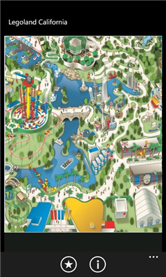
Legoland California Live Map Legoland California Live Map - Find your way at Legoland California. This app shows your current location on the attractions map.
Note: this app is unofficial - it is not affiliated with Legoland