JTrip - Create your own trip in Thailand. JTrip recommends attractions and directions that you need. Let's get to know Thailand together.
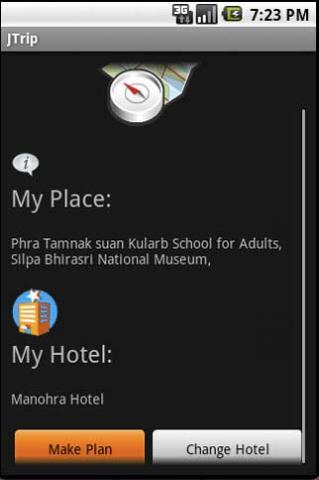
· select places.
· select hotel.
· show map location.
· route path form src to dest.
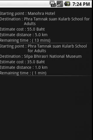
· taxi, time remaining.
· suggest bus number.
· suggest mrt/bts stations with gps current location.
· open facebook.
Like it? Share with your friends!
Supported operating systems:
Google Android 1.0, Google Android 1.5, Google Android 1.6, Google Android 10.x, Google Android 2.0, Google Android 2.1, Google Android 2.2, Google Android 2.3, Google Android 3.0, Google Android 3.1, Google Android 3.2, Google Android 4.0, Google Android 4.1, Google Android 4.2, Google Android 4.3, Google Android 4.4, Google Android 5.x, Google Android 6.x, Google Android 7.x, Google Android 8.x, Google Android 9.x
Similar Software:
TTC Subway Rider Efficiency Guide TTC Subway Rider Efficiency Guide - This application has maps of all TTC (Toronto Transit Commission) subway stations so you can see where the stairs/etc are... and plan where to stand on the platform.
Based on ttcrider.ca
Useful for handicapped people too
OS Map OS Map is a tool to turn your Android phone into a handy Ordnance Survey map, with your GPS position pinpointed on it!
· Nearly all OS Map scales available (including 250,000 and 50,000).
· Touch-scrolling - simply use your finger to drag the map around.
· Fast resume from standby and fast position updates
OpenStreetMapViewer OpenStreetMapViewer provides Tools / Views to interact with OpenStreetMap-Data
Yelp: Food, shopping, services Yelp - is an application, which will let you find places you are interested in on the map within seconds. This wonderful guide on seraching for wonderful facilities to eat, drink, have rest or have fun. In this application you will find reviews on facilities, see pictures, get the location and even order delivery
amAze (Sony Ericsson) AmAze is a first of its kind free navigation and local search service. It is free to download and use and it contains wide coverage of maps including aerial photo in Europe, North America, Australia and parts of Asia and Africa
MapDroyd MapDroyd - Of course, today there are many Android application featuring street maps. Most of them are based on Google Maps, which means you've to enable your mobile device's network connection through a GPRS or Wifi connection
BostonBusMap BostonBusMap is an application for Android phones. It uses GPS data provided by the MBTA to plot the real-time location of buses on a map.
What's New in This Release:
· GPS now turns on when you start the app to allow quicker location lookup times
HERE WeGo - Offline maps & GPS HERE WeGo - will always help you find the needed way in the city. The application will offer the best routes for any mode of transport or for going on foot. This utility will take you to the destination point with the help of voice messages and will inform you about extra ways in case of change on the road
Metro LX Metro LX is a comprehensive guide to the Lisbon Subway providing:
A map of Lisbon Metro (subway) in landscape and portrait modes;
A route planner between stations;
A map route to station from your position;
And detailed information per Station.
What's New in This Release:
· Updated tariff (February 2012);
· Minor bugs fixed on tablets
Locus Free Locus Free - Fast and useful Online/Offline map viewer for Android.
· This is also My Maps editor so Google Account permission is needed
· Contacts permission is for getting contact address on various places in app (adding point into database by contact address, etc..
Other Software by developer «Annop Kobkij»:
not found
Comments on JTrip:
Comments not found
If you noted an error or download link is broken, please, report it via this page or use comments.
JTrip is compatible with your device Alcatel One Touch Pixi 3 4.0 Dual SIM LTE OT-4050J


")


