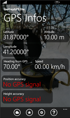
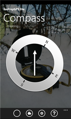
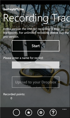
JaefreyGPS lite - This app enables you to view your current position and course. Futhermore you can record a track while walking or driving and upload this track as kml-file to your Dropbox account.
If you have any questions or suggestions, please feel free to contact us. In a couple of weeks you can also find our JaefreyGPS Pro application on the marketplace with a lot of additional features.
update to version 1.1:
- fixed bug that sometimes it was not possible to save the settings
Like it? Share with your friends!
If you got an error while installing Themes, Software or Games, please, read FAQ.
Supported operating systems:
Windows 10 Mobile, Windows Phone 7, Windows Phone 8
Similar Software:
Mobile Speedo Mobile Speedo - Mobile Speedo uses your mobile phone's GPS to accurately display your current location, direction and speed. You can also record, share and review this information.
Features:-
Display current speed, average speed, distance travelled, top speed and compass heading
Infusion LIS Mobile Locator Infusion LIS Mobile Locator - Don't miss the chance to be there when your customers need you. INFUSION LIS MOBILE LOCATOR LET YOUR CUSTOMERS FIND YOU FASTER.
Infusion LIS Mobile Locator guides customers to your business quickly and accurately
Where Am I This application allows to create check point with gps position and (in future release) upload to a community server, to track my movements and find my friends
OS Grid Refs OS Grid Refs - A simple app that displays the phone's current location as an Ordnance Survey grid reference.
n.b. This will only be of use if the your current location lies inside the OS national grid. Using the app outside the UK will give no reading
Friend Finder Share your location and request your friend's location easily, securily and instantly with friend finder
Car Locator Car Locator keeps you close to your parking spot - no matter where you're headed to. This clever mobile parking application allows you to keep an eye on your parking spot without getting nervous about parking charge times or retrieving your car.
Pinpoint the exact location of your parking spot, both visually and by address
GPS tracker GPS tracker - The app can be used to track the current position of the user using GPS data. Data that can be obtained are :
- Latitude
- Longitude
- Altitude
- Course ( Direction )
- Current Speed
The above said data can be sent as a referance using either SMS or E-Mail
SOS lite SOS lite - This program let you make calls or send text with your location when you are in a emergency,
and need for help.
*Lite version:
2 cases limit
no calls, text only
" - SOS lite - " mark at the bottom of message
advertisment
Follow this steps to complete setting:
1. You may define different cases that you may encounter
(Ex
My_Geo_App My_Geo_App - By using this app you can locate theirself in the map.
This app consists lot of things and some of them are:
1. Horizontal accuracy
2. Vertical accuracy
My app will contain the following specifications:
1. My Location Details
2. My Location View
3. Road view/ Arial view
4. U can urself on map
5. Zoom in/zoom out
6. Stop services a
Other Software by developer «bios2000»:
JaefreySmartPlayer JaefreySmartPlayer - With the JaefreySmartPlayer you got a tool to create and play playlists with music located on your Windows Phone. Furthermore you can fall asleep by hearing your favorite songs, because you are able to define a time, where the app goes to sleep mode and save your charge of battery. Also the awake from your sleep is possible
JaefreyGPS Lite JaefreyGPS Lite This application enables you to view your current position and course. Furthermore you can record a track while walking or driving and upload this track as kml-file to your Dropbox account
JaefreyGPS Pro JaefreyGPS Pro is the paid in and in functions enhanced version of JaefreyGPS lite.
With this application you can get your GPS position and the direction angle. Furthermore, the app allows the recording of unlimited tracks and uploading it as .kml or .gpx file in your Dropbox account. You can take various tools such as Google Maps to evaluate the path data