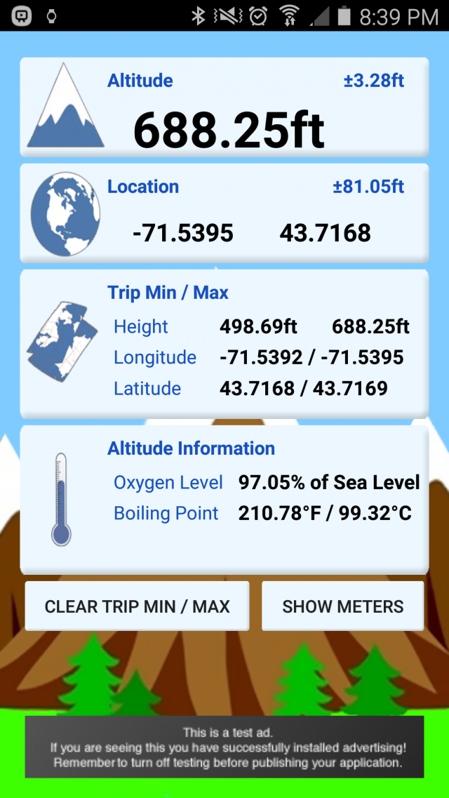
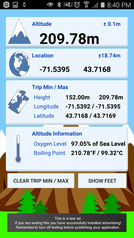
myAltitude - See your Altitude, and details of your trip, including Minimum and Maximum Altitudes, Oxygen levels and more! Full Android Wear support!
Includes improved & tested support for:
Moto 360
ASUS ZenWatch and
Samsung Gear
Like it? Share with your friends!
Supported operating systems:
Google Android 10.x, Google Android 4.0, Google Android 4.1, Google Android 4.2, Google Android 4.3, Google Android 4.4, Google Android 5.x, Google Android 6.x, Google Android 7.x, Google Android 8.x, Google Android 9.x
Similar Software:
3D Compass (AR Compass) 3D Compass (AR Compass) - 3D compass with augmented reality view, Auto rotate map, Big heading degrees
This is a compass app with augmented reality view and real time map update, and provides real time location information
Epic Compass Epic Compass - When you are a traveler or lost in somewhere place, you must need a compass. Caompass can be used in outdoor and many activities you can do such as hiking, climbing, flying etc
GeoLog GeoLog saves the sensors data (gps, accelerometer, magnetometer data, etc.) of your device to a log file and calculates the coverage of the site. The coverage is a ratio of the track covering area to the area of the site (expressed in percents)
Sun Moon Dial Sun Moon Dial - A Sun and Moon Compass dial. A fun visual app to show off the compass feature of the g1.
Before your Comment - THIS IS A DEMO app -- just wanted to show something that the iphone couldn't do. This app has no purpose - it was written in about an hour (plus a couple to make the kiddie graphics)
GPS Speed GPS Speed - Turn your Android phone into a digital speedometer! Nice Compass view + big digital speed view. You can use menu to switch m/s, MPH, KPH and Knot.
What's New in This Release:
· minor fix
What's New in 5.4:
· support APP2SD
What's New in 4
GPS Coordinates Converter GPS Coordinates Converter - With this app you can convert GPS coordinates from "degrees, minutes, decimal seconds" to "decimal degrees".
What's New in This Release:
· Locate your phone and show the coordinates
What's New in 2
Speedometer Speedometer - GPS speedometer for Android phones.
· Measures: speed, elapsed time, all distance, peak and average speed.
· Acceleration 0-60-100-150 km/h
· The fastest distance(100m, 1/4 mile, 500m and 1km).
· Draws charts for speed and altitude.
· Speed, all distance, peak and average values, compass.
· Speed alerts
GPS Status & Toolbox GPS Status & Toolbox - Be a GEEK: Get the most out of your phone. Raw GPS data at your fingertips.
Display your GPS and sensor data: position and signal strength of satellites, accuracy, speed, acceleration, bearing.
Tools included: compass with magnetic and true north, leveling tool, mark or share your location and navigate back later
MUUDS MUUDS - Our Patented, color-coded, UV resistant PVC MUUDS Markers are a new and unique way to mark the exact depth of underground utilities. They are excellent way to prevent future excavation disasters
iPocket Tools Deluxe Best deal EVER! Why pay for 9 applications that may not be as good, when you can get all of these quality applications in ONE? ✓Bubble Level ✓Caliper ✓Clinometer/Inclinometer
✓Flashlight ✓Plumb bob ✓Protractor ✓Ruler ✓Voice Battery Tool ✓Voice Compass
Other Software by developer «Rovingsquid»:
not found
Comments on myAltitude:
Comments not found
If you noted an error or download link is broken, please, report it via this page or use comments.
myAltitude is compatible with your device Alcatel One Touch POP 2 5.0 Dual SIM LTE 7043E


")


