Outdoor Share for Android - The Outdoor Navigation software is your best friend through your adventures in the wild.
Go into the outdoors with confidence and enjoy your activities without worrying about the tools to help you navigate. Your Outdoor Navigation app is made by the people who have been developing this software since 2003 across multiple platforms. Be sure that you will stay ahead of the rest with continuous updates and relevant tools.
It is an excellent tool for biking, jogging, skiing, hiking, geocaching, boating, flying and many other sporting activities.
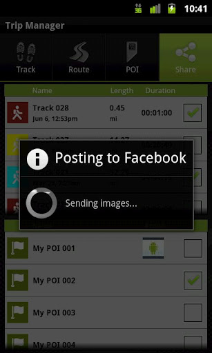
Your Outdoor Share will give you the ability to take those valuable tracks and POIs that you have created with your Outdoor Navigation base application and share them with your Facebook pals by uploading them to your Facebook account.
· Allows to share tracks and POIs with Facebook (besides the sharing via mail that is available also in the base version)
Installation instructions:
Outdoor Share is an add-on for the free Outdoor Navigation application. You need to have your Outdoor Navigation installed to be able to use Outdoor Share.
Download and install Outdoor Share on your Android device. Start the Outdoor Share plugin to complete the license checking: when activation will be completed then the icon will be removed (you need to restart your device to hide the icon) and the plugin will be used inside Outdoor Navigation application.
What's New in This Release:
· Bug fixing
Like it? Share with your friends!
Supported operating systems:
Google Android 10.x, Google Android 2.1, Google Android 2.2, Google Android 2.3, Google Android 3.0, Google Android 3.1, Google Android 3.2, Google Android 4.0, Google Android 4.1, Google Android 4.2, Google Android 4.3, Google Android 4.4, Google Android 5.x, Google Android 6.x, Google Android 7.x, Google Android 8.x, Google Android 9.x
Similar Software:
GPS Widget GPS Widget - This widget simply shows your current location in numbers. Latitude and Longitude are received from the GPS location provider or from the network location provider if GPS is not available.
The altitude is queried from open MapQuest API which yields in a more accurate result than receiving the altitude by GPS
GPSbySMS (Android) GPSbySMS is an application that reads navigation data from GPS and sends it to any user via SMS or email.
Purpose:
1) Read navigation data from GPS and send it to any user via SMS or email.
2) View current position on Maps (need Internet connection).
3) Save navigation data in database using data transfer via GPRS Internet.
4) Alarm Function
yozi yozi is a navigation software for the Android platform. It uses digital topographic maps in well-known Ozi Explorer formats for navigation and doesn't require network access like built-in Maps application on Android
Sygic: GPS Navigation Sygic: GPS Navigation - Sygic is the premium turn-by-turn GPS navigation app. Sygic boasts an intuitive interface: drag the map, pinch to zoom, change point of view using built-in compass and tap target square to choose action. Sygic is comfortable and safe: advanced routing is optimized for Real-Time Traffic
Local Local - Local is your best application to find any place you are looking for near you. Local offers you so easy and customized search with best filtered results, show you places as per user ratings. You can see complete details of a local place like opening and closing timings, map, Google+ profile, users reviews, price range
Garmin Tracker (Android) Garmin Tracker (Android) - Brought to you by the worldwide leader in GPS, Garmin Tracker — combined with a GPS-enabled Garmin tracking device (purchase required) — lets you track what’s important while on the go.
Garmin Tracker is a free, unique application that will help keep tabs on whatever is important to you
GPSHunt GPSHunt - GPS application like a handheld GPS designed by hunters for hunters. You can use it in a hunting game where you use a GPS to hide and seek containers with other participants in the activity.
What's New in This Release:
· support APP2SD
What's New in 4.0:
· minor optimization
What's New in 3
NearMe NearMe application gives you a fast and easy way to find places near you. In addition, you can set the area (in Km) where to search. With every found place you have some useful options:
* Call
* Add To Contacts
* Open In Maps
* Get Directions
And other option is History: it keeps for you all places you have searched for
GPS status & toolbox GPS status & toolbox - is a very useful program for working with GPS. This utility is aimed at viewing GPS condition and settings. It can display all data of a sensor and GPS: positions and satellite signal power, accuracy, speed, acceleration, height, step and even battery status
OpenSatNav OpenSatNav brings open-source satellite navigation to Android handsets.
· All code is open source.
· Global maps and navigation based on OpenStreetMap data
· Navigation by car, bicycle or by foot
Other Software by developer «GPS Tuner»:
GPS Tuner Essentials Full Version with Balkans Basic Map Content GPS Tuner Essentials Full Version with Balkans Basic Map Content is designed specifically for off-road use: its large buttons, selectable tool window size, multiple Compass views and the built-in Tele Atlas map makes it extremely user-friendly and reliable
GPS Tuner Essentials Full Version with Germany, Austria, Switzerland Basic Map Content GPS Tuner Essentials Full Version with Germany, Austria, Switzerland Basic Map Content is designed specifically for off-road use: its large buttons, selectable tool window size, multiple Compass views and the built-in Tele Atlas map makes it extremely user-friendly and reliable
GPS Tuner Atlas Full Version with South America Basic Map Content GPS Tuner Atlas Full Version with South America Basic Map Content is designed specifically for off-road use: its large buttons, selectable tool window size, multiple Compass views and the built-in Tele Atlas map makes it extremely user-friendly and reliable
GPS Tuner Essentials Full Version with France, Monaco, Belgium, Switzerland Basic Map Content GPS Tuner Essentials Full Version with France, Monaco, Belgium, Switzerland Basic Map Content is designed specifically for off-road use: its large buttons, selectable tool window size, multiple Compass views and the built-in Tele Atlas map makes it extremely user-friendly and reliable
Outdoor Compass for Android Outdoor Compass for Android - The Outdoor Navigation software is your best friend through your adventures in the wild.
Go into the outdoors with confidence and enjoy your activities without worrying about the tools to help you navigate. Your Outdoor Navigation app is made by the people who have been developing this software since 2003 across multiple platforms
Outdoor Offline Maps for Android Outdoor Offline Maps for Android - The Outdoor Navigation software is your best friend through your adventures in the wild.
Go into the outdoors with confidence and enjoy your activities without worrying about the tools to help you navigate. Your Outdoor Navigation app is made by the people who have been developing this software since 2003 across multiple platforms
GPS Tuner Essentials Full Version with Iberia Basic Map Content GPS Tuner Essentials Full Version with Iberia Basic Map Content is designed specifically for off-road use: its large buttons, selectable tool window size, multiple Compass views and the built-in Tele Atlas map makes it extremely user-friendly and reliable
US Terrain Intelligence for Android US Terrain Intelligence for Android - The Outdoor Navigation software is your best friend through your adventures in the wild.
Go into the outdoors with confidence and enjoy your activities without worrying about the tools to help you navigate. Your Outdoor Navigation app is made by the people who have been developing this software since 2003 across multiple platforms
Outdoor Navigation Pro for Android Outdoor Navigation Pro for Android - The Outdoor Navigation software is your best friend through your adventures in the wild.
Go into the outdoors with confidence and enjoy your activities without worrying about the tools to help you navigate. Your Outdoor Navigation app is made by the people who have been developing this software since 2003 across multiple platforms
GPS Tuner Essentials Full Version with Nordic Countries Basic Map Content GPS Tuner Essentials Full Version with Nordic Countries Basic Map Content is designed specifically for off-road use: its large buttons, selectable tool window size, multiple Compass views and the built-in Tele Atlas map makes it extremely user-friendly and reliable


")


