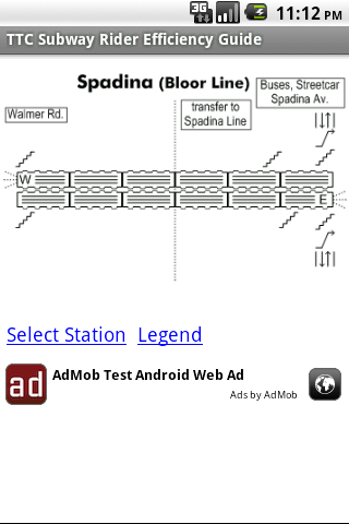
TTC Subway Rider Efficiency Guide - This application has maps of all TTC (Toronto Transit Commission) subway stations so you can see where the stairs/etc are... and plan where to stand on the platform.
Based on ttcrider.ca
Useful for handicapped people too.
What's New in This Release:
· Now includes tips
· App is smaller (because using smaller ad library)
What's New in 1.4.3:
· Tweaks
Like it? Share with your friends!
Supported operating systems:
Google Android 1.5, Google Android 1.6, Google Android 10.x, Google Android 2.0, Google Android 2.1, Google Android 2.2, Google Android 2.3, Google Android 3.0, Google Android 3.1, Google Android 3.2, Google Android 4.0, Google Android 4.1, Google Android 4.2, Google Android 4.3, Google Android 4.4, Google Android 5.x, Google Android 6.x, Google Android 7.x, Google Android 8.x, Google Android 9.x
Similar Software:
Navigator Navigator - detailed maps with the support of satellite navigation. You need to specify two points to make a route. You can track your current location and set those coordinates as the route start. Thanks to marks on the map you can easily find a fuel station, restaurant or hotel
InstaMapper (Android) InstaMapper is a free service that allows you to track a person or vehicle online in real time using a GPS-enabled mobile phone.
To use InstaMapper, you create a free account. Registration takes only a minute or two. All it is asked for is a username, password, and a valid email address.
Next, you install a small application on your GPS-enabled phone
Android Location Android Location is your free, location-aware, mobile social network.
Meet real world friends. Reveal your location, befriend, and chat with people around you.
Using location-based technologies, Android Location lets you see where your friends are and what they are up to, in real time. Meet people around you. Discover who visits your favorite places
MapsWithMe Pro for Android MapsWithMe Pro for Android - MapsWithMe allows you to access maps of all the countries in the world while on the go. The maps are based on OpenStreetMap data and work completely offline, without requiring an internet connection
amAze (Sony Ericsson) AmAze is a first of its kind free navigation and local search service. It is free to download and use and it contains wide coverage of maps including aerial photo in Europe, North America, Australia and parts of Asia and Africa
Walk And Run Keeper Walk And Run Keeper - Lets you measure how far you ran/walked, track your walking distance, speed, time, and calories burned and store a record of your daily workouts to stay fit.
This is the best way to maintain walking schedules. Use this app and measure your walking route and calculate your burned calories per session
Mobilex GPS Logger Mobilex GPS Logger - Overview ========================== The Android GPS Logger application captures GPS updates, and saves latitude and longitude coordinate fixes to text files on micro SD card. Supported Features inlcude: ============================== Google Maps. Satellite, Traffic and Street Views
Barcelona DK Eyewitness Top 10 Travel Guide & Map (BlackBerry) Barcelona DK Eyewitness Top 10 Travel Guide & Map (BlackBerry)- -From Gaudi''s mind-boggling buildings to the Gothic Quarter, your holiday to Barcelona starts the moment you open the guide, plus Barcelona maps and metro maps
AugSatNav Walk AugSatNav is an augmented reality navigation system which overlays walking directions upon a live video feed of the path or road ahead.
With AugSatNav there is no need to follow instructions or interpret maps - you can simply find your way by walking along the route highlighted by a bright white line
flea papa flea papa Care about your communities by knowing what people near you are thinking, saying, doing, selling, wanting and needing. With a patent-pending Search By Route technology, you can also connect with people or objects of interest along travel routes when you are on a trip
Other Software by developer «Dave McKellar»:
Dividend Predictor - Free Dividend Predictor - For the dividend investor.
Enter the symbols of stocks you own, the application looks up the details online and shows what future dividends you'll get.
Do you have a mix of regular stocks that pay quarterly and ETFs that pay monthly? -- no problem.
Or for "what if", enter stocks you might want to buy and see how they pay
Hockey Team Hockey Team - For the coach or captain of a recreational hockey team.
Given the number of players who showed up in the dressing room... how many forwards and how many defense is that?!
Also suggests how you might divide up your forwards.
Language is gender-neutral so you can use it for girls/women teams too.
Please note: this application is *not* a game
Wi-Fi Map Maker - Free Wi-Fi Map Maker is application makes a map of Wi-Fi access points as you walk around.
· Maps out the actual coverage of each access point!
· Access point names are displayed on the map
· See street address and area of access points
· You can select the criteria for inclusion on your map
HashPost - Free HashPost - Free - A special purpose Twitter application. Its sole purpose in life is to make it easy for you to include #lots of #hashes in your Tweets. Ideal for Live Tweeting an event.
Profile Hashes:
· Enter them once and they are always included


")


")


")


