GeoSense - Ever wondered how you would know if you have reached a destination you've never been before? GPS is great .. but should you be checking out the GPS on a regular basis just to make sure? Or what if you Sleep off?
Why not tag an alarm to a specific location? Even if this is possible, can I be notified before I've reached the place? GeoSense does just that !!!
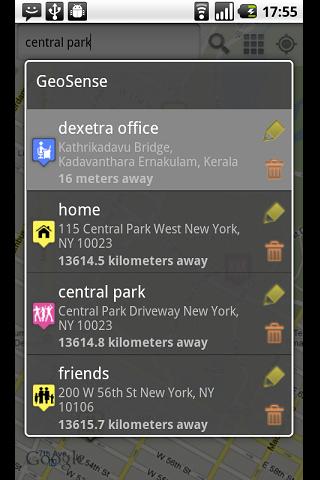
GeoSense is an unique application that helps you remember and reminds you of locations.
· Add any number of locations to from the map.
· Location alerts to each hotspot.
· Location reminders when you come within the specified proximity.
· Add categories to POIs
· Lists POIs based on distance from you.
· Intelligent battery use.
Like it? Share with your friends!
Supported operating systems:
Google Android 1.5, Google Android 1.6, Google Android 10.x, Google Android 2.0, Google Android 2.1, Google Android 2.2, Google Android 2.3, Google Android 3.0, Google Android 3.1, Google Android 3.2, Google Android 4.0, Google Android 4.1, Google Android 4.2, Google Android 4.3, Google Android 4.4, Google Android 5.x, Google Android 6.x, Google Android 7.x, Google Android 8.x, Google Android 9.x
Similar Software:
Mobbyway Mobbyway based on both internet mobile technologies and GPS, Mobbyway allows you to know easily, at any time, your relatives’ exact position on a map if they have accepted it and if they are connected to the network.Mobbyway is also a help on the road network with a local alert system of a dangerous zone which is carried out with the network of members
MapMyRun+ for Android MapMyRun+ for Android - MapMyRun is a fitness assistant designed to allow runners, joggers and walkers to track their workouts using their phone's built-in GPS.
With the app you can view your route on a map and record your workout details, including duration, distance, pace, speed, elevation and calories burned
Android Location Android Location is your free, location-aware, mobile social network.
Meet real world friends. Reveal your location, befriend, and chat with people around you.
Using location-based technologies, Android Location lets you see where your friends are and what they are up to, in real time. Meet people around you. Discover who visits your favorite places
Modern Compass Modern Compass this compass does what the compass always was intended to do, it helps you locate the destination of your choice.
Using GPS technology and Google maps, this application lets you mark a destination of choice and then shows in what direction that destination lies, as well as how far away it is from your current location
OSMTracker for Android OSMTracker stands for OpenStreetMap Tracker. It allows you to track your journey and mark significant way points. Way points can be marked with a tag using a button, with a quick voice record, a text note or by taking a picture. The various button pages and layouts can be customized to suit your OpenStreetMap activities
Hunting the Snark Hunting the Snark - Inspired by Lewis Carrol's poem, The Hunting of the Snark, Hunting the Snark is an action game played on both your GPS-enabled Android device and in the real world. In it, you hunt a Snark (the creature on the map in blue.) If you invade its physical location before the game time has expired, you win. Otherwise, you lose
MapMyRIDE GPS Cycling Riding MapMyRIDE GPS Cycling Riding - tracks the route, distance, pace, and more in real-time using GPS.
NEW: iMapMyRIDE+ for Android
iMapMyRIDE+ brings you its mobile app for Android-based devices! Now owners of Android 2
AndNav2 (Android) AndNav2 is a navigation system for Android-powered phones. AndNav2 is based on free mapdata by OpenStreetMap.org. AndNav2 will provide full audible turn-by-turn realtime route-guidance. AndNav2 has unique features, like Text-2-Speech, an accessibility-study (aka 'Where can I get in 30 minutes') or avoiding customizable areas, i.e
Foursquare Foursquare - helps you explore the world around you. Keep up with friends, get insider tips, and unlock discounts and rewards.
While on the go, you can easily tell friends where you are, share pictures, get their comments ("I'm right around the corner, I'll stop by to say hello"), and get insider tips ("order the Lobster Ravioli; it's the best dish by far
GpsTicker Gpsticker is a program for outdoor orientation and navigation with GPS, it is best for hiking and biking. Maps are downloaded automatically from OpenStreetMaps, provided the Phone has an active internet connection
Other Software by developer «Dexetra»:
SpeedSense SpeedSense turns your Android phone into a virtual Dashboard. You get all sorts driving info, such as:
* Top Speed
* Avg
Tintumon: Rebirth Tintumon: Rebirth - The kingdom of Mallusia is under siege by the Evil Kanka and his men


")


