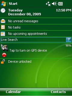
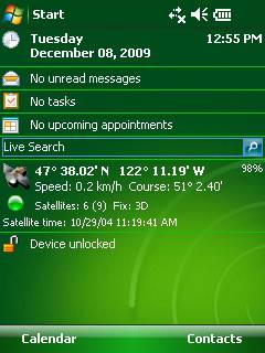
GPS2day is a today screen plug-in showing your current GPS coordinates, speed, satellite info, etc... Languages: English, Czech, Dutch, French, German, Hungarian, Italian, Japanese, Polish, Russian, Spanish.
Currently GPS2day program works as GPS informer. It supports both metric and U.S. (Imperial) units and shows a various types of information for users, such as:
Current geographical coordinates (latitude, longitude);
Course and speed;
Some information about satellites and fix type;
Altitude followed by the fix 3D value;
Exact current date and time from the satellite atomic clock;
And battery life state which is important when you using GPS device.
What's New in This Release:
· Translation to Japanese was added
Like it? Share with your friends!
If you got an error while installing Themes, Software or Games, please, read FAQ.
Supported operating systems:
Windows Mobile 5.0, Windows Mobile 6 Classic, Windows Mobile 6 Professional, Windows Mobile 6.1 Classic, Windows Mobile 6.1 Professional, Windows Mobile 6.5 Professional
Similar Software:
Map of Rhode Island (US State) Map of Rhode Island (US State) - A map of the Rhode Island by VITO Technology. Good for intercity travels with SmartMap.
SmartMap is a mobile device application which uses vector and raster maps. It is compatible with any NMEA protocol GPS receiver (Compact Flash socket, serial port, BlueTooth or sleeve)
Speereo Voice Translator: English-Finnish (WM Smart) Speereo Voice Translator (SVT) is an ideal companion for traveling on business or leisure and also is an excellent aid for business communication. Running on Windows Mobile and Symbian based mobile devices it contains of over 4000 phrases in each of 16+ languages and many other useful features
Travel Great Smoky Mountains National Park - illustrated guide and maps Travel Great Smoky Mountains National Park - illustrated guide and maps. Indulge Yourself with a personal tour guide on Your PDA. FREE General Information and map in the trial.
Features
Fully illustrated.
Interesting facts.
Multiple Maps
Attractions.
The guide is loaded into the device memory.
No network access needed
GPSLogGoogle Follow the route you have taken on Google Earth using the log made by your PocketPC
Map of Oklahoma (US State) Map of Oklahoma (US State) - A map of the Oklahoma by VITO Technology. Good for intercity travels with SmartMap.
SmartMap is a mobile device application which uses vector and raster maps. It is compatible with any NMEA protocol GPS receiver (Compact Flash socket, serial port, BlueTooth or sleeve)
Map4Fun Hong Kong Map4Fun Hong Kong - Going to Hong Kong? just download it for free!
Attractions and shops/hotels/restaurants... in Honk Kong, find coupons/POI instant video/communication links...on hand, and much more of major Asian cities at Map4fun.
1. Hong Kong Information.
2. Useful numbers. 3. Tourist attraction.
4. Sheung Wan/Central area map.
5
Map of Milan / Italy for City Advisor Milan / Italy map for City Advisor. Includes all tube lines, all urban trains lines, all tramway lines, all bus lines and supports full timetables.
Instructions:
1. Download the map (zip file)
2. Extract the files in /CityAdvisor/maps
3. Open CityAdvisor -> Maps icon -> Menu -> Refresh
4
TwitsnapsMaps TwitsnapsMaps uses the GPS on your PocketPC to find your current latitude/longitude/speed and altitude and allows you to upload your position via map to Twitter.com. You can customize the maps zoom, and type via the 'Options' in the toolbar. The maps service is provided by Google.com. The map/Twitter storage is from TwitSnaps
Other Software by developer «Soft Expanse Group»:
ShellSwitcher ShellSwitcher was implemented as a Windows Mobile system utility for fast switching between well known shells: Spb Mobile Shell, Titanium (WM6.5 default shell), Touch Flo 3D, HTC Sense and classic Today screen. This application is based on UI Switcher knowledge with some additional features


")
")
![USA-WY [Wyoming] Map for EagleEye PDA Tracking System](https://static.mobyware.org/data/images/def_program_reduced.png "USA-WY [Wyoming] Map for EagleEye PDA Tracking System")


")


