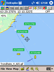
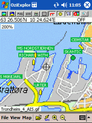
AIS2OZI - AIS2OZI tracks ship positions. It is a logger/decoder/plotter for PocketPC.
Ship positions are plotted directly in OziExplorer Download AIS2OZI (Make backup of Shiplist.txt when reinstalling.)
Decodes AIVDM sentences of types 1, 2, 3 and 5, i.e. position reports for class A shipborne equipment plus vessel information.
Like it? Share with your friends!
If you got an error while installing Themes, Software or Games, please, read FAQ.
Supported operating systems:
Windows Mobile 5.0, Windows Mobile 6 Classic, Windows Mobile 6 Professional, Windows Mobile 6.1 Classic, Windows Mobile 6.1 Professional, Windows Mobile 6.5 Professional
Similar Software:
SmartCaddie Pro SmartCaddie Pro with GPS
Thousands of courses, if your course is not there we will simply add it for you
12 players or more, special versions are available for leagues.
Includes enrolment for one user in the Nova Golf Internet Network (NGIN) providing further features and functions
amAze (Windows Mobile) AmAze is a first of its kind free navigation and local search service. It is free to download and use and it contains wide coverage of maps including aerial photo in Europe, North America, Australia and parts of Asia and Africa
JVTrip JVTrip - Track yourself while you are on a trip, walking, cycling, driving or just watch your child move. And then export the path to Google Earth.
You can add notes, costs or pictures to your path. This information will be stored with the GPS location where you added them. When you export your track to Google Earth, all information will be there as markers
TasksGPSer TasksGPSer allows you to create date/time stamped tasks based on your current GPS. When you get a GPS lock then you can create a text task for the area. The program has a full featured file explorer that displays the tasks in order of distance from your current GPS. The map service is provided by Google
FON Access Points for Dominican Republic FON Access Points for Dominican Republic - FON offers you a new Points of Interest service (POIs). This allows you to download FONspots directly to your navigation device.
What does that mean? You can download a Points of Interest file directly to your navigation device
FacebookGPS FacebookGPS allows you to update your status on FaceBook with a GPS link to a Google.com mobile map. Tap the button to get a GPS lock. Once you have a lock enter your status update and your FaceBook.com status will be updated with a link to the Google.com Mobile maps. This service is provided by FaceBook
GPSed Pocket PC GPSed - Record GPS tracks from your mobile and trace them on a map.
Record tracks of your trips anywhere on the Earth from your mobile device. Tracks are traced on Google Maps and stored in an online archive. All you need to start tracking is a mobile device with the internal or external GPS receiver
AccountingGPS AccountingGPS - Each sheet has the GPS home setting and you can use the GPS on your PocketPC to view the distance of every sheet. Select the sheet to view/edit the entry for it. You can also view a Google.com map of your current or the sheets GPS
OS GPS Convertor OS GPS Convertor converts positions between WGS84 latitude & longitude and Ordnance Survey (OS) British & Irish or Universal Transverse Mercator (UTM) worldwide grid references. It displays positions in multiple formats.
It can be used with:
* TomTom Navigator - to create a Point of Interest (POI) or Itinerary file ... then show on map, navigate to, etc
Other Software by developer «Frank Dahlslett»:
not found
Comments on AIS2OZI:
Comments not found
If you noted an error or download link is broken, please, report it via this page or use comments.


")


