Categories: Business & Profession, Travel & Navigation
Upload date: 20 Oct 10
Developer: MrRalphMan
License: Freeware
Downloads: 8466 File Size: 626 Kb
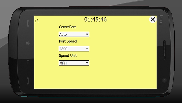
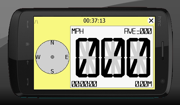
hdSpeedo is a speedometer that is driven from a GPS signal.
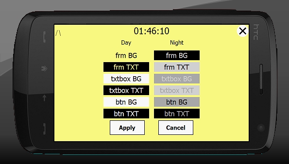
· User configurable background colours
· Day/Night colour schemes (Choose by clicking on the top status bar)
· Rotatable (Portrait or Landscape)
· Gesture enabled (Move between screens)
· Point and Track logging now available as .kml files
· satellite position location page
· Ability to flip speedo panel to allow use for a HUD
What's New in This Release:
· Journey stats saved in /My Documents/hdSpeedo
· Tidied up the /My Documents/hdSpeedo folder.
· Error logging to file
· Display of Max speed. This swaps every 15 secs with the AVG speed
Like it? Share with your friends!
If you got an error while installing Themes, Software or Games, please, read FAQ.
Supported operating systems:
Windows Mobile 2003, Windows Mobile 5.0, Windows Mobile 6 Classic, Windows Mobile 6 Professional, Windows Mobile 6.1 Classic, Windows Mobile 6.1 Professional, Windows Mobile 6.5 Professional
Similar Software:
GPSLoggerer GPSLoggerer logs and displays the data that comes from your GPS unit in your device in NMEA sentences. You can select the output to a NMEA extension or or text file extension. When you select save all logs after the save will be saved to the file. When you select close the logging will stop
VoicePOIer VoicePOIer - VoicePOIer is a full-featured named voice recorder with GPS location tagger. You can make named voice recordings and the GPS location is appended to the end of the file. You can browse the files via GPS distance. Tap on the wave file to play it back.
This program requires that you have both the 'BeanDLL
AgMapper AgMapper - Create maps using your Windows Mobile device. Measure lengths and view areas without the desktop PC.
AgMapper makes it easy to map what ever you like and share it with other software packages by using the very common shape file format (.shp) to store your mapping data.
Load images onto your map created using the FREE AgMapper Image Converter
PocketGPS Map PocketGPS Map-The program views calibrated bitmap maps (moving maps) on Pocket PC / WinCE platform.
Additionaly it supports using GPS device to retrieve user position and show it (with other marks) in map - making it very handy for geocaching
Navigation BE-ON-ROAD UK and Eire Q2/2011 Navigation BE-ON-ROAD UK and Eire Q2/2011 - The new major version of be-on-road presents new features and is based on new platform which brings high level of reliability, portability and speed on almost any kind of device. The new be-on-road brings high value voice guided door-to-door navigation
FON Access Points for France FON Access Points for France - FON offers you a new Points of Interest service (POIs). This allows you to download FONspots directly to your navigation device.
What does that mean? You can download a Points of Interest file directly to your navigation device
TrackMyRun TrackMyRun is a simple GPS Run/Walk tracking application for Windows Mobile
HyperGPS TMC Driver HyperGPS is an application that allows you to use the built-in FM radio of your mobile device to receive traffic alerts and incorporate them on real time automatically to your navigation program in order to recalculate routes and avoid traffic jams
GPS Clock GPS Clock - This application is part of the author's "30 Days of .NET" initiative to develop 30 mobile applications in 30 days. The source code of the application is included in order to help programmers new to Windows Mobile development write applications in .NET.
I couldn't resist creating another GPS related mobile application
TwitterGPSing TwitterGPSing allows you to send GPS based tweets to Twitter. When you get a GPS lock enter the text and tap the button to send the Tweet with your current GPS. The program will send the tweet to Twitter.com with your current GPS. NOTE: To use Geolocation on Twitter in 'Settings/Account/Tweet Location' enable. This service is provided by Twitter
Other Software by developer «MrRalphMan»:
not found
Comments on hdSpeedo:
Comments not found
If you noted an error or download link is broken, please, report it via this page or use comments.