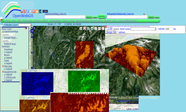
OpenWebGIS - OpenWebGIS is created for everyone who wishes to see and use a new free&open Geographic Information System(GIS). Please make your comments and suggestions. In this GIS you can use the extensive mathematical functionality to calculate and analyze your data. Using OpenWebGIS you will get a GIS at your disposal, it may be similar in functionality to some desktop GIS. Please support this project. The OpenWebGIS for Android has online and local version. In local version, you can use OpenWebGIS without having to connect to the server of OpenWebGIS and even without Internet connection. In local version, some functions do not work, but in future there will be the modification of these functions for the local version. The OpenWebGIS blog (http://openwebgisystem.blogspot.com/) provide a lot of information about possibilities for users' data operating. Full list of articles about OpenWebGIS: http://openwebgisystem.blogspot.com/2015/08/list-of-articles-about-openwebgis-in.html
Like it? Share with your friends!
Supported operating systems:
Google Android 10.x, Google Android 3.0, Google Android 3.1, Google Android 3.2, Google Android 4.0, Google Android 4.1, Google Android 4.2, Google Android 4.3, Google Android 4.4, Google Android 5.x, Google Android 6.x, Google Android 7.x, Google Android 8.x, Google Android 9.x
AppInventor Toggle AppInventor Toggle - This is a simple utility application that allows one click enabling of the two features needed to work with Google's latest AppInventor. With one button, the application disables orientation sensing and enables "stay awake" on USB/AC power with Toast notifications
SEO Basics SEO Basics - Here you can read up the basics of SEO-Search engine optimization tips and tutorials on improving websites and blogs visibility on search engines. We write about Search Engine Optimization and Search Engine Marketing of websites and blogs like SEO news Search Engine Marketing news and Social Netwoks news
Simply Facebook Simply Facebook is a light, simple, extensible Java library for accessing and modifying data available through the Facebook API. This is a useful tool on the Android platform, as the SDK does not ship with any means for accessing the Facebook API.
This library uses the Desktop mode approach for authentication
JSONovich - Firefox Addon JSONovich - Firefox Addon is a Firefox extension that pretty-prints JSON content of various types directly in a browser tab. It uses the browser's native JSON parser and a custom-built formatter to produce its output.
Normally, Firefox would prompt to download JSON sent with the correct application/json mime-type
Learn ASP Net Learn ASP Net - ASP.NET is a web application framework developed and marketed by Microsoft to allow programmers to build dynamic web sites. It allows you to use a full featured programming language such as C# or VB.NET to build web applications easily. This tutorial covers all the basic elements of ASP.NET that a beginner would require to get started
Add-on Compatibility Reporter Add-on Compatibility Reporter - Help Mozilla make sure your favorite add-ons get updated for upcoming Firefox releases by using this extension to report whether they still work or are having some issues with alpha and beta releases
Learn Design Patterns Learn Design Patterns - Design patterns represent the best practices used by experienced object-oriented software developers. Design patterns are solutions to general problems that software developers faced during software development. These solutions were obtained by trial and error by numerous software developers over quite a substantial period of time
Common Language Extension for Android Common Language Extension for Android - CLE is a common extension platform, which presents a general method for mixed language calls. It supports distributed object technique, which objects as medium to implement the mixed call between languages. Object is presented as a structured memory with a list of function pointers
Comments on OpenWebGIS:
Comments not found
If you noted an error or download link is broken, please, report it via this page or use comments.
Please, select device to check if OpenWebGIS supports it