Outdoor Chart for Android - The Outdoor Navigation software is your best friend through your adventures in the wild.
Go into the outdoors with confidence and enjoy your activities without worrying about the tools to help you navigate. Your Outdoor Navigation app is made by the people who have been developing this software since 2003 across multiple platforms. Be sure that you will stay ahead of the rest with continuous updates and relevant tools.
It is an excellent tool for biking, jogging, skiing, hiking, geocaching, boating, flying and many other sporting activities.
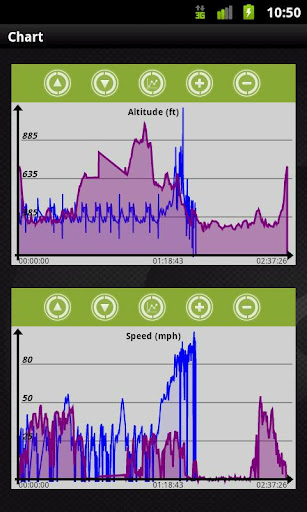
Your Outdoor Chart will give you the ability to analyze your tracks with great detail using any of the available 3 chart types. Compare your speed, acceleration or altitude on multiple trips simultaneously and be able to view 5 tracks at the same time on the same chart. You may also to choose a layout, where your tracks are displayed on a chart and a map at the same.
· Select 5 charts (instead of only one)
· Switch between charts
· View on map selected chart(s)
Installation instructions:
Outdoor Chart is an add-on for the free Outdoor Navigation application. You need to have your Outdoor Navigation installed to be able to use Outdoor Chart.
Download and install Outdoor Chart on your Android device. Start the Outdoor Chart plugin to complete the license checking: when activation will be completed then the icon will be removed (you need to restart your device to hide the icon) and the plugin will be used inside Outdoor Navigation application.
What's New in This Release:
· Bug fixing
Like it? Share with your friends!
Supported operating systems:
Google Android 10.x, Google Android 2.1, Google Android 2.2, Google Android 2.3, Google Android 3.0, Google Android 3.1, Google Android 3.2, Google Android 4.0, Google Android 4.1, Google Android 4.2, Google Android 4.3, Google Android 4.4, Google Android 5.x, Google Android 6.x, Google Android 7.x, Google Android 8.x, Google Android 9.x
Similar Software:
urban pole This app is for urban pole a new and exiting way to get fit
Personal Coach Personal Coach - It doesn't matter whether you are on a bike, foot or skis.
Personal Coach is an exercise planner with GPS logger which monitors, calculates and saves exercise parameters:
· time
· speed
· distance
· exercise route shown on map
· calories burnt
The results, including route in KML format, can be sent by email
5 Minute Workout 5 Minute Workout - High intensity 5 minute workout training to lose weight, shape muscles and improve cardiovascular health with fitness girl personal trainer to motivate and guide you. Over 20 different training workouts designed to burn fat in the shortest time possible
Runtastic Road Bike Pro for Android Runtastic Road Bike Pro for Android - Runtastic Road Bike turns your Android device into a powerful cycling computer.
The app uses your phone's GPS to track your route on a map and provides useful information such as elapsed time, traveled distance, speed, altitude, calories burned, weather, etc
Building Muscle & Strength Work on your body, strengthen your muscles and make the change in your life! You will not only feel better but also look better!!
Neuroid Neurosky driver for Android with Audio feedback on Meditation level
Bodybuilding Workout Log Bodybuilding Workout Log - Features: + free choice of exercises. You do not need to deal with a long list of exercises that you never use in your workouts
Cool Pedometer Cool Pedometer - "Pedometer" records the number of steps you have walked and displays them again along with the number of calories that you have burned, distance, walking time and speed per hour. It is easy to use. Once you push the Start button, all you have to do is hold your smartphone as you always do and walk
iMapMyFITNESS+ Fitness App iMapMyFITNESS+ Fitness App - tracks the route, distance, pace, and more in real-time using GPS.
Free new version!
iMapMyFITNESS brings you its mobile app for Android-based devices! Now owners of Android 2.1 or higher devices can track the route, time, distance, speed, pace and calories in real-time for their fitness activities using their GPS enabled mobile device
Daily 7 Minutes Workout Daily 7 Minutes Workout - Daily 7 Minutes Workout offers you a big amount of info that will help you to reach your goals. 7 Min Abs Workout has many exercises and workouts for training at your home. Features of Daily 7 Minutes Workout app:- • Different workouts that will help you to be fit. • Different guided workouts that will allow you to practice abs workout
Other Software by developer «GPS Tuner»:
GPS Tuner Essentials Full Version with BENELUX Basic Map Content GPS Tuner Essentials Full Version with BENELUX Basic Map Content is designed specifically for off-road use: its large buttons, selectable tool window size, multiple Compass views and the built-in Tele Atlas map makes it extremely user-friendly and reliable
GPS Tuner Essentials Full Version with France, Monaco, Belgium, Switzerland Basic Map Content GPS Tuner Essentials Full Version with France, Monaco, Belgium, Switzerland Basic Map Content is designed specifically for off-road use: its large buttons, selectable tool window size, multiple Compass views and the built-in Tele Atlas map makes it extremely user-friendly and reliable
GPS Tuner Atlas Full Version with Full Europe Basic Map Content GPS Tuner Atlas Full Version with Full Europe Basic Map Content is designed specifically for off-road use: its large buttons, selectable tool window size, 6 different types of Compass views and the built-in Tele Atlas map makes it extremely user-friendly and reliable
GPS Tuner Essentials Full Version with Nordic Countries Basic Map Content GPS Tuner Essentials Full Version with Nordic Countries Basic Map Content is designed specifically for off-road use: its large buttons, selectable tool window size, multiple Compass views and the built-in Tele Atlas map makes it extremely user-friendly and reliable
GPS Tuner Essentials Full Version with Central Europe Basic Map Content GPS Tuner Essentials Full Version with Central Europe Basic Map Content is designed specifically for off-road use: its large buttons, selectable tool window size, multiple Compass views and the built-in Tele Atlas map makes it extremely user-friendly and reliable
US Terrain Intelligence for Android US Terrain Intelligence for Android - The Outdoor Navigation software is your best friend through your adventures in the wild.
Go into the outdoors with confidence and enjoy your activities without worrying about the tools to help you navigate. Your Outdoor Navigation app is made by the people who have been developing this software since 2003 across multiple platforms
GPS Tuner Essentials Full Version with Balkans Basic Map Content GPS Tuner Essentials Full Version with Balkans Basic Map Content is designed specifically for off-road use: its large buttons, selectable tool window size, multiple Compass views and the built-in Tele Atlas map makes it extremely user-friendly and reliable
GPS Tuner Essentials Full Version with United States Basic Map Content GPS Tuner Essentials Full Version with United States Basic Map Content is designed specifically for off-road use: its large buttons, selectable tool window size, multiple Compass views and the built-in Tele Atlas map makes it extremely user-friendly and reliable
Outdoor Speedometer for Android Outdoor Speedometer for Android - The Outdoor Navigation software is your best friend through your adventures in the wild.
Go into the outdoors with confidence and enjoy your activities without worrying about the tools to help you navigate. Your Outdoor Navigation app is made by the people who have been developing this software since 2003 across multiple platforms