TouringNavigation - It is a navigation application program for the motorcycle and the bicycle, etc.
It is a navigation application for the motorcycle and the bicycle, etc.
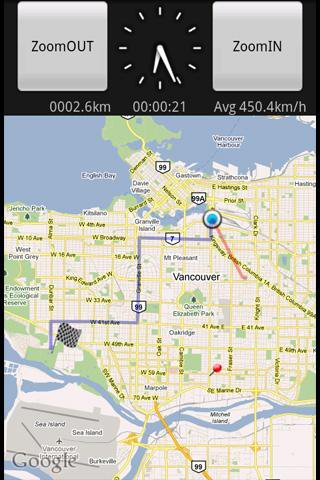
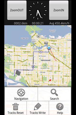
This application displays the route guide, tracks, the mileage that has been passed, the running time , and the mean time velocity.
Tracks that have been passed also provide the function to output to the SD card by the GPX format.(GPS Logger)
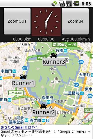
This application provides the location sharing service "Where everyone?".
"Where everyone?" is ability to understand each other, where you are now someone else on the map.
*** Let's try "Where everyone?" ***
Please push Menu button,
and tap the 'Where everyone?' button.
The Input dialog is displayed.
Input keyword 'test' and Tap 'OK' button.
The map is displayed, Please see aroud Tokyo Japan.
you can see 4 test runnners.
Like it? Share with your friends!
Supported operating systems:
Google Android 1.5, Google Android 1.6, Google Android 2.0, Google Android 2.1, Google Android 2.2, Google Android 2.3, Google Android 3.0, Google Android 3.1
Similar Software:
GPS Map Search Compass & Track An app for all the purpose so what you're waiting for....!!! Yes.... creatiosoft proudly introduced an awesome GPS Toolbox where you can do anything whatever you desired. Lets track all the locations of yourself via GPS where you are expedition
Local Local - Local is your best application to find any place you are looking for near you. Local offers you so easy and customized search with best filtered results, show you places as per user ratings. You can see complete details of a local place like opening and closing timings, map, Google+ profile, users reviews, price range
AndNav2 (Android) AndNav2 is a navigation system for Android-powered phones. AndNav2 is based on free mapdata by OpenStreetMap.org. AndNav2 will provide full audible turn-by-turn realtime route-guidance. AndNav2 has unique features, like Text-2-Speech, an accessibility-study (aka 'Where can I get in 30 minutes') or avoiding customizable areas, i.e
Art Places Art Places is a software application for the Android mobile operating system.
The application gets our position through the GPS in the mobile device and shows us our current location in the maps application. of maps
VGPS (Vietnamese GPS) for Android VGPS (Vietnamese GPS) for Android was designed to use city street map on your ordinary mobile phone without the need of having GPS receiver or internet connection. VGPS does not require internal or external GPS receiver. However, if you have internal GPS receiver or external bluetooth GPS receiver, VGPS can work with your GPS receiver as well
NAVIGON Eastern Europe for Android NAVIGON Eastern Europe for Android - NAVIGON turns your mobile device into a fully featured GPS navigation system. The software provides advanced functionality for both drivers and pedestrians, including 2D and 3D maps, route planner, speed assistant, voice directions, local search, and more
meet-me FREE meet-me With only a few fingertips you can find your friends in the biggest crowd. Their location is presented by a stylish arrow and distance. Awesome: the positions are dynamically updated
AndTripLog AndTripLog allows you to record your trip onto your device. The application displays the current GPS position, time and speed. You can export the trip by email and store it onto your sdcard in GPX format
Pocket Caddy Pocket Caddy - #1 Golf GPS app: 3D flyover of holes, yardage to greens, shot recording, stats, scorecard, hazard carry or lay up position. Positioning is shot to hole, not cart to hole. Free PC Analytics inc. 3D Google Earth replay with stats, and Free DIY Course Mapping software both available from www.satsportsna
Gps Traveler Gps Traveler - Gps Traveler is a complete gps tools for android including compass,speedometer,gps Information such as speed,altitude,location address infromation
Other Software by developer «kazuhito kawabe»:
not found
Comments on TouringNavigation:
Comments not found
If you noted an error or download link is broken, please, report it via this page or use comments.
Please, select device to check if TouringNavigation supports it


")

 for Android")


