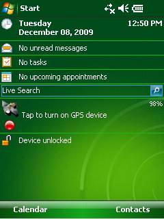
GPS2day is a today screen plug-in showing your current GPS coordinates, speed, satellite info, etc... Languages: English, Czech, Dutch, French, German, Hungarian, Italian, Japanese, Polish, Russian, Spanish.
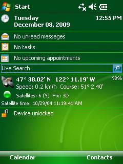
Currently GPS2day program works as GPS informer. It supports both metric and U.S. (Imperial) units and shows a various types of information for users, such as:
Current geographical coordinates (latitude, longitude);
Course and speed;
Some information about satellites and fix type;
Altitude followed by the fix 3D value;
Exact current date and time from the satellite atomic clock;
And battery life state which is important when you using GPS device.
What's New in This Release:
· Translation to Japanese was added
Like it? Share with your friends!
If you got an error while installing Themes, Software or Games, please, read FAQ.
Supported operating systems:
Windows Mobile 5.0, Windows Mobile 6 Classic, Windows Mobile 6 Professional, Windows Mobile 6.1 Classic, Windows Mobile 6.1 Professional, Windows Mobile 6.5 Professional
TextMapperer TextMapperer - TextMapperer allows you to create named text based GPS maps. When you get a GPS lock then you can create a new map and enter text for the area. When you save the text the map is downloaded and the text and GPS is appended to the end of the map with current GPS
Brighton Pocket A-Z Map Brighton Pocket A-Z Map - This publication has been designed for a Windows® Mobile-based Pocket PC (version 2002 or later) and The Pocket A-Z Viewer. The map covers an area of Brighton extending to Seaford, Ferring, Steyning, Lewis and Ringmer
Map of Wisconsis (US State) Map of Wisconsis (US State) - A map of the Wisconsis by VITO Technology. Good for intercity travels with SmartMap.
SmartMap is a mobile device application which uses vector and raster maps. It is compatible with any NMEA protocol GPS receiver (Compact Flash socket, serial port, BlueTooth or sleeve)
amAze (Motorola) AmAze is a first of its kind free navigation and local search service. It is free to download and use and it contains wide coverage of maps including aerial photo in Europe, North America, Australia and parts of Asia and Africa
Traffic Vizzion (12 month subscription) IMPORTANT: Do not operate this product while driving; park the vehicle first. It is your sole responsibility to place, secure and use your mobile device in a manner that ensures safe driving
Global Navigator Global Navigator is the most powerful and easy to use GPS navigation software on your Pocket PC with:3D GPS Navigation all over the world + Offline map and satellite image + Map range download+ 3D street view
Map of Suriname Map of Suriname - A map of the Suriname by VITO Technology. Good for intercity travels with SmartMap.
SmartMap is a mobile device application which uses vector and raster maps. It is compatible with any NMEA protocol GPS receiver (Compact Flash socket, serial port, BlueTooth or sleeve)
A-Z Mini London Street Atlas A-Z Mini London Street Atlas From the publishers of London''s best selling paperback street atlas comes this publication designed for a Windows® Mobile-based Pocket PC (version 2002 or later) and Pocket A-Z Viewer (included)
Other Software by developer «Soft Expanse Group»:
ShellSwitcher ShellSwitcher was implemented as a Windows Mobile system utility for fast switching between well known shells: Spb Mobile Shell, Titanium (WM6.5 default shell), Touch Flo 3D, HTC Sense and classic Today screen. This application is based on UI Switcher knowledge with some additional features


")

")
")


