mdNavMobile is a waypoint-based GPS navigation solution for the Windows Mobile platform. It can guide you from waypoint to waypoint while keeping you informed of all relevant navigation data. All NMEA-data from a GPS is automatically logged to file so you can 'replay' a trip with variable speed.
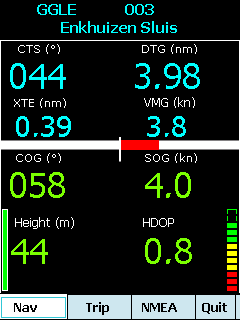
· GPS info: Latitude, Longitude, COG, SOG, Height, Satellites, HDOP and NMEA-stream
· Waypoint info: CTS, DTG, TTG, VMG, XTE
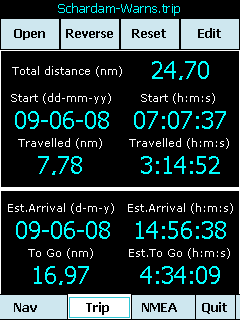
· Trip info: Total distance, Start, Travelled distance/time, DTG, TTG, ETA
· Reverse and Reset trips
· Scroll to next/previous waypoint
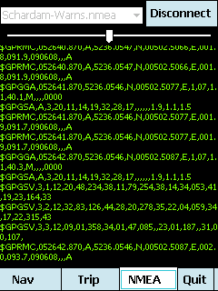
· Logs full NMEA stream from GPS to Storage Card
· Simulation using NMEA-log files with variable speed (factor 0.01-100)
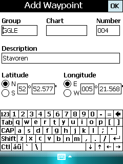
· Create/Edit Trips and Waypoints
· Show data in nm/kts/ft or km/kmh/m
· Change colors
· Trip-files also editable with notepad
· Totally free
Like it? Share with your friends!
If you got an error while installing Themes, Software or Games, please, read FAQ.
Supported operating systems:
Windows Mobile 5.0, Windows Mobile 6 Classic, Windows Mobile 6 Professional, Windows Mobile 6.1 Classic, Windows Mobile 6.1 Professional, Windows Mobile 6.5 Professional
Similar Software:
GPSWM65Mapping GPSWM65Mapping - GPSWM65Mapping is a full featured map downloader that uses GPS. You can enter the lat/long coordinates or use your current GPS location to download a map. You can download in GIF, PNG or JPEG format. The app has several options to customize the map. The map service is provided by Google
FON Access Points for Monaco FON Access Points for Monaco - FON offers you a new Points of Interest service (POIs). This allows you to download FONspots directly to your navigation device.
What does that mean? You can download a Points of Interest file directly to your navigation device
FON Access Points for Luxembourg FON Access Points for Luxembourg - FON offers you a new Points of Interest service (POIs). This allows you to download FONspots directly to your navigation device.
What does that mean? You can download a Points of Interest file directly to your navigation device
GPS.Friend additional licence GPS.Friend additional licence - This is only additional licence, for the second and every next phone device. It is valid only with your base licence of this program
FON Access Points for Kuwait FON Access Points for Kuwait - FON offers you a new Points of Interest service (POIs). This allows you to download FONspots directly to your navigation device.
What does that mean? You can download a Points of Interest file directly to your navigation device
FasterFix FasterFix - Do you live outside the US? Are you bored of setting your gps.conf manually? The answer to all (or at least one) of your problems is FasterFix.
What's New in This Release:
· Added Germany, France and Japan
· Move to SD support
What's New in 1.0:
· Over 5000 users, no bugreports since RC3. appears to be stable
SpeedTracker SpeedTracker - Designed and tested by an experiment Marathoner, SpeedTracker is dedicated to on-road and off-road Sport practice.
Directly available from your finger tip, Cycler, Runner, Roller, ... find a set of selected options to plan,control and manage workout sessions
ppc PhotoGeoTag ppc PhotoGeoTag - Take pictures with your mobile phone and incorporate the data of the geographical location. The application allows you to include in the photographs, data from the GPS receiver, along with a brief note. If you know the coordinates, not having the GPS receiver, you can also handwrite geographic data
SafetyRide SafetyRide Limiting the scope of searches in case of emergency, this mobile application helps people who need to walk in dangerous places. Keeping a GPS connection and sending SMS to a configured number with the latest position at determined intervals
FON Access Points for Dominican Republic FON Access Points for Dominican Republic - FON offers you a new Points of Interest service (POIs). This allows you to download FONspots directly to your navigation device.
What does that mean? You can download a Points of Interest file directly to your navigation device
Other Software by developer «Maurits Dijkens»:
not found
Comments on mdNavMobile:
Comments not found
If you noted an error or download link is broken, please, report it via this page or use comments.
mdNavMobile is compatible with your device AnyDATA ASP-318