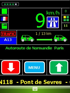
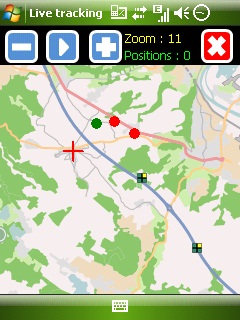
Mobbyway - Based on both internet mobile technologies and GPS, Mobbyway allows you to know easily, at any time, your relatives’ exact position on a map if they have accepted it and if they are connected to the network.
Mobbyway is also a help on the road network with a local alert system of a dangerous zone which is carried out with the network of members. Finally, Mobbyway will reference all the fixed radars in the countries where it is used and Mobbyway will indicate them to you.
Mobbyway was developed to allow:
- you to stay connected with your relatives wherever they are.
- your relatives to follow you visually and in real time.
- you to go back at any time to a place where you have already been on a specific date.
- you to travel safely on the road network thanks to the network members: The Mobbynautes.
- you to have a part in the world cartography OpenStreet Map
Like it? Share with your friends!
If you got an error while installing Themes, Software or Games, please, read FAQ.
Supported operating systems:
Windows Mobile 6 Classic, Windows Mobile 6 Professional, Windows Mobile 6.1 Classic, Windows Mobile 6.1 Professional, Windows Mobile 6.5 Professional
Similar Software:
ExerciseGPSs ExerciseGPSs - ExerciseGPSs uses the GPS on your PocketPC to view on a large display your walking/running/riding speed on a moving graph. You can use this to keep your exercise pace. NOTE: The program does not display/graph 0 speeds.
This program requires that you have both the 'BeanDLL.dll' file ** and ** the runtime files for Visual Basic on your PocketPC computer
FON Access Points for Costa Rica FON Access Points for Costa Rica - FON offers you a new Points of Interest service (POIs). This allows you to download FONspots directly to your navigation device.
What does that mean? You can download a Points of Interest file directly to your navigation device
MapTexterer MapTexterer - MapTexterer allows you to create text based GPS maps. When you get a GPS lock then you can create a new map and enter text for the area. When you save the text the map is downloaded and the text and GPS is appended to the end of the map with current GPS.
This program requires that you have both the 'BeanDLL
MyGPS_PDA MyGPS_PDA - MyGPS_PDA is a light MyGPS version for PocketPC systems. It reads the NMEA sentences coming from a GPS antenna connected to the PocketPC and shows your position on a MyGPS calibrated map. The program can also store on a file the track log together with specific waypoints created by the user
Hotfix for resolving difficulties finding or locating a position when using GPS for HTC Touch Pro Hotfix for resolving difficulties finding or locating a position when using GPS for HTC Touch Pro - If it is difficult to find or locate a position when using GPS, download this hotfix to solve the problem.
Copy the hotfix, which is an .exe file, to your device. To install the hotfix, tap the .exe file and follow the on-screen instructions
ppc FindMyCar ppc FindMyCar - Innovative software for Windows Mobile devices that uses the GPS signal to show signs that allow to reach a geographic location.
Suitable for various uses (eg. find car parked in a parking area or in an unknown city, finding a person (who has sent their coordinates) in a lovely beach, in a fair, in another boat, find an area of sea fishing, etc..)
AIS2OZI AIS2OZI - AIS2OZI tracks ship positions. It is a logger/decoder/plotter for PocketPC.
Ship positions are plotted directly in OziExplorer Download AIS2OZI (Make backup of Shiplist.txt when reinstalling.)
Decodes AIVDM sentences of types 1, 2, 3 and 5, i.e. position reports for class A shipborne equipment plus vessel information
Mobile Altimeter Mobile Altimeter -Altimeter for windows mobile devices. We have a background that symbolizes "altitude" which is appealing to end users. Plus it gives the program a lot of style and class
GPSEmailer GPSEmailer uses the GPS on your PocketPC to find your latitude/longitude/altitude and speed and creates a blank Email template. When the program gets its first lock then it creates an email with your GPS update location and a link to the Google.com mobile online street map
Gippos Gippos is an application for mobile devices allowing the user to locate his or her position on the map, share the location with friends and see other users on the same map. Users can also exchange instant messages with their friends
Other Software by developer «Mobbyway»:
Mobbyway Mobbyway based on both internet mobile technologies and GPS, Mobbyway allows you to know easily, at any time, your relatives’ exact position on a map if they have accepted it and if they are connected to the network.Mobbyway is also a help on the road network with a local alert system of a dangerous zone which is carried out with the network of members


")
")