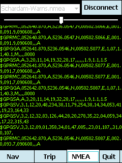
mdNavMobile is a waypoint-based GPS navigation solution for the Windows Mobile platform. It can guide you from waypoint to waypoint while keeping you informed of all relevant navigation data. All NMEA-data from a GPS is automatically logged to file so you can 'replay' a trip with variable speed.
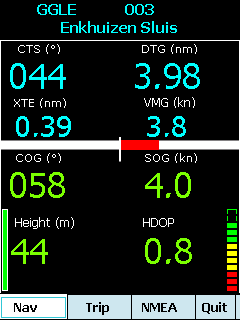
· GPS info: Latitude, Longitude, COG, SOG, Height, Satellites, HDOP and NMEA-stream
· Waypoint info: CTS, DTG, TTG, VMG, XTE
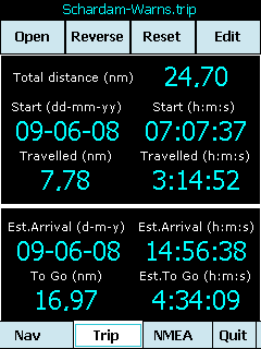
· Trip info: Total distance, Start, Travelled distance/time, DTG, TTG, ETA
· Reverse and Reset trips
· Scroll to next/previous waypoint
· Logs full NMEA stream from GPS to Storage Card
· Simulation using NMEA-log files with variable speed (factor 0.01-100)
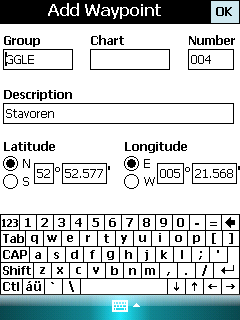
· Create/Edit Trips and Waypoints
· Show data in nm/kts/ft or km/kmh/m
· Change colors
· Trip-files also editable with notepad
· Totally free
Like it? Share with your friends!
If you got an error while installing Themes, Software or Games, please, read FAQ.
Supported operating systems:
Windows Mobile 5.0, Windows Mobile 6 Classic, Windows Mobile 6 Professional, Windows Mobile 6.1 Classic, Windows Mobile 6.1 Professional, Windows Mobile 6.5 Professional
Similar Software:
PictureGPSer PictureGPSer - PictureGPSer checks the camera storage folder for new pictures/videos and when detected places the current GPS tag at the end of the image/video. You can also view the images via a distance file viewer. You can also view and download a map of the pictures from Google.com.
This program requires that you have both the 'BeanDLL
FON Access Points for Zambia FON Access Points for Zambia - FON offers you a new Points of Interest service (POIs). This allows you to download FONspots directly to your navigation device.
What does that mean? You can download a Points of Interest file directly to your navigation device
TwitsnapsMaps TwitsnapsMaps uses the GPS on your PocketPC to find your current latitude/longitude/speed and altitude and allows you to upload your position via map to Twitter.com. You can customize the maps zoom, and type via the 'Options' in the toolbar. The maps service is provided by Google.com. The map/Twitter storage is from TwitSnaps
amAze (Motorola) AmAze is a first of its kind free navigation and local search service. It is free to download and use and it contains wide coverage of maps including aerial photo in Europe, North America, Australia and parts of Asia and Africa
PoliceSyncer PoliceSyncer - PoliceSyncer can be used by a Police officer to create dated GPS POI based note/picture/video logs and also share information on a secure remote FTP server with other police officers. The program uses the GPS on the PocketPC to find the distance of each GPS POI point and you can view or download the map the points on Google.com map service
FON Access Points for Poland FON Access Points for Poland - FON offers you a new Points of Interest service (POIs). This allows you to download FONspots directly to your navigation device.
What does that mean? You can download a Points of Interest file directly to your navigation device
TwitterGPSerer TwitterGPSerer allows you to oAuth update and view Twitter contacts via GPS. You can use the GPS to find your current location and send a tweet and also track your friends via Twitter. The map service is provided by Google.com. The tweet service is provided by Twitter
GPS Tracker GPS Tracker is a part of a fleet management software system, which is used to track mobile phone activity (e.g. mobile phone can be used as a gps tracking device).
The application will monitor the GPS activity and it will send the data to the http://voznipark.virtualniured.hr online server
GPSSpeedometerer GPSSpeedometerer uses the GPS on your PocketPC to find your speed based on the NMEA RMC sentence
GPSSateliter GPSSateliter displays the GPS satellite listings and strength as a graph. When you tap the 'Start GPS' button the program will look for GPS satellites and graphically display the decibel of each. The more bars the better your GPS coverage
Other Software by developer «Maurits Dijkens»:
not found
Comments on mdNavMobile:
Comments not found
If you noted an error or download link is broken, please, report it via this page or use comments.
mdNavMobile is compatible with your device AnyDATA ASP-318


")


