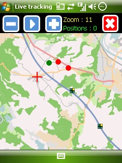
Mobbyway - Based on both internet mobile technologies and GPS, Mobbyway allows you to know easily, at any time, your relatives’ exact position on a map if they have accepted it and if they are connected to the network.
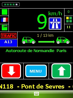
Mobbyway is also a help on the road network with a local alert system of a dangerous zone which is carried out with the network of members. Finally, Mobbyway will reference all the fixed radars in the countries where it is used and Mobbyway will indicate them to you.
Mobbyway was developed to allow:
- you to stay connected with your relatives wherever they are.
- your relatives to follow you visually and in real time.
- you to go back at any time to a place where you have already been on a specific date.
- you to travel safely on the road network thanks to the network members: The Mobbynautes.
- you to have a part in the world cartography OpenStreet Map
Like it? Share with your friends!
If you got an error while installing Themes, Software or Games, please, read FAQ.
Supported operating systems:
Windows Mobile 6 Classic, Windows Mobile 6 Professional, Windows Mobile 6.1 Classic, Windows Mobile 6.1 Professional, Windows Mobile 6.5 Professional
Similar Software:
FileGPSes FileGPSes - FileGPSes allows you to browse and execute the GPS tagged files and view them sorted in distance from your current GPS. You can also view and download the files placed on a Google.com map. This program uses "The Vincenty inverse formula for ellipsoids." (accuracy to within 0.5mm, or 0
FON Access Points for Czech Republic FON Access Points for Czech Republic - FON offers you a new Points of Interest service (POIs). This allows you to download FONspots directly to your navigation device.
What does that mean? You can download a Points of Interest file directly to your navigation device
Pocket PC Geocaching Tools Pocket PC Geocaching Tools - Many tools in one program to help you while you are geocaching.
What's included?
* Open GSAK databases directly
* HTML view
* Field Notes
* Hint decoder and decryption
* Several coordinate functions
* Solver
* Transformer (Text to Digits, etc
waze Waze - Waze is a free, 100% user-generated, social navigation application that allows drivers to build and use live maps & real-time traffic updates to improve their daily commute
GPS Tuner Essentials Full Version with Iberia Basic Map Content GPS Tuner Essentials Full Version with Iberia Basic Map Content is designed specifically for off-road use: its large buttons, selectable tool window size, multiple Compass views and the built-in Tele Atlas map makes it extremely user-friendly and reliable
BikeTrack BikeTrack - This application enables everybody (who got your user/pass) look up your location on the net, using your the page http://fiets.galway.nl/ and keeps track of you.
On the webpage you can also create a username so you can use the software.
What it does:
- Gets location from GPS.
- Sends it to BikeTrack Server
MapWM Record GPS data with your Windows Mobile device
Locify With Locify you can explore interesting places near you from Wikipedia, seek for geocaches, display map where you are (or you want to go), twitter your location, save interesting places from phone or web sync them and even navigate to them... and much more.
Locify is free application for common mobile phone
Navitel Navigator for Windows Mobile Navitel Navigator for Windows Mobile - Navitel Navigator is a GPS travel assistant for Windows Mobile. The app turns your phone into a personal navigation system.
Navitel Navigator comes with detailed maps and other useful features, including traffic jams, speedcams, 3D roads and intersections, instant routing and a comprehensive database with points of interest
CellGPSer CellGPSer uses the cellular signal on your device to instantly find your approximate GPS. Tap the button while your phone is on and the program will send your cellular tower information to OpencCellID.org. The program will then display the approximate GPS. This service is provided by OpenCellID
Other Software by developer «Mobbyway»:
Mobbyway Mobbyway based on both internet mobile technologies and GPS, Mobbyway allows you to know easily, at any time, your relatives’ exact position on a map if they have accepted it and if they are connected to the network.Mobbyway is also a help on the road network with a local alert system of a dangerous zone which is carried out with the network of members


")
")