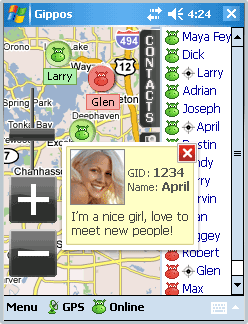
Gippos is mobile software for locating yourself and other users on the map and for instant messaging. Feel the city pace
Do you like to meet new people on the streets? Chat with them for free? Know where your friends are?
Meet and communicate without trouble! Enjoy nature
Arranging a picnic in a beautiful place? Inviting your friends for a country walk? Your friends will easily find you on a map!
· Find your friends on a map
· Meet new people around you
· Chat for free
What's New in This Release:
· Jabber protocol is used for messaging now.
· Jabber users from other servers can be added to contact list.
· Loading last messages to chat log window is added.
· Chat history viewing is added.
· Avatar loading is added.
· "About Gippos" info window is added.
· Maps switching logic is improved.
· Three modes of user's location visibility are implemented.
· New chat statuses are added.
· Gippos auto updating at new version release is added.
· "Don't turn the device off while the application is running" feature is implemented.
· Viewing user's location, history, and profile from chat window is added.
· Manually locating oneself on the map is added.
· Search window interface is changed
Like it? Share with your friends!
If you got an error while installing Themes, Software or Games, please, read FAQ.
Supported operating systems:
Windows Mobile 5.0, Windows Mobile 6 Classic, Windows Mobile 6 Professional, Windows Mobile 6.1 Classic, Windows Mobile 6.1 Professional, Windows Mobile 6.5 Professional
Similar Software:
PictureSharer PictureSharer - This program allows you to send/receive JPEG pictures via IRDA.
This program requires that you have both the 'BeanDLL.dll' file ** and ** the runtime files for Visual Basic on your PocketPC computer. Simply unzip the file for your processor and place the DLL file in the 'Windows' folder of your PocketPC computer. For free support on installing email me
TaxiGPSer TaxiGPSer - TaxiGPSer uses the GPS on your PocketPC to find your current latitude/longitude/speed and allows you to send it to a preset Taxi or shuttle service via email. Tap the button to get the GPS lock and when the program gets the lock it will send the email.
This program requires that you have both the 'BeanDLL
GPS Tuner Atlas Full Version with Full Europe Basic Map Content GPS Tuner Atlas Full Version with Full Europe Basic Map Content is designed specifically for off-road use: its large buttons, selectable tool window size, 6 different types of Compass views and the built-in Tele Atlas map makes it extremely user-friendly and reliable
FON Access Points for Guatemala FON Access Points for Guatemala - FON offers you a new Points of Interest service (POIs). This allows you to download FONspots directly to your navigation device.
What does that mean? You can download a Points of Interest file directly to your navigation device
RulerGPSed RulerGPSed - RulerGPSed uses the GPS on your PocketPC to calculate geodesic distance in 3 formats between two points specified by the latitude/longitude of your GPS using "The Vincenty inverse formula for ellipsoids" (accuracy to within 0.5mm, or 0.000015").
This program requires that you have both the 'BeanDLL
FON Access Points for Austria FON Access Points for Austria - FON offers you a new Points of Interest service (POIs). This allows you to download FONspots directly to your navigation device.
What does that mean? You can download a Points of Interest file directly to your navigation device
Virtual Orienteering Virtual Orienteering is a new way of practicing orienteering outdoor sport. All you need is a GPS capable smartphone like iPhone, Android, Windows Phone 7 or Windows Mobile device. Next all we need to do is to go outdoor, play and have fun! Virtual Orienteering is a game played outdoor inspired from Orienteering sport
AccountingGPS AccountingGPS - Each sheet has the GPS home setting and you can use the GPS on your PocketPC to view the distance of every sheet. Select the sheet to view/edit the entry for it. You can also view a Google.com map of your current or the sheets GPS
GPSWM65Ruler GPSWM65Ruler uses GPS to find the distance between two points using "The Vincenty inverse formula for ellipsoids." (accuracy to within 0.5mm, or 0.000015"). Select 'Start GPS' to start the GPS and when you get a lock you can view your current location. Tap the button to save it and measure your distance. The map service is provided by Google
FON Access Points for Czech Republic FON Access Points for Czech Republic - FON offers you a new Points of Interest service (POIs). This allows you to download FONspots directly to your navigation device.
What does that mean? You can download a Points of Interest file directly to your navigation device
Other Software by developer «Gippos»:
not found
Comments on Gippos:
Comments not found
If you noted an error or download link is broken, please, report it via this page or use comments.
Gippos is compatible with your device AnyDATA ASP-318