Symbian OS | Pocket PC | Smartphone | Android | BlackBerry | Apple iPhone OS | Java | Mobile Gaming | Linux | Palm | Win CE | Tablet  
     

Free Mobile Software, Themes, Games, Apps for PDA and Smartphones

     
Search by Device
My Device

  
Last Viewed Apps
Froggy Feed
Dodol keyboard
Touch Puzzle
Anesthesia Pain Service Database for HanDBase
GScroll
Adblock Lite - Firefox Addon
Torchcraft - Minecraft torch
Oh slide puzzles
Cisco OnPlus Mobile
Tic Tac Toe Game
Search by Category
Business & Profession
Databases
Dictionary & Translator
Entertainment
Finance
Games
Healthcare & Medicine
Internet & Communications
Multimedia & Graphics
Organisation & Productivity
Programming & Development
Reading
Science & Education
System Utilities
Themes & Wallpapers & Skins
Travel & Navigation
Geocaching
GPS
Guides
Maps
Measuring & Compass
Travel Planning
Weather
Worldtime
More
Search by Platform
Android
Apple iPhone OS
iPad
iPhone
iPod Touch
BlackBerry
Java
Linux
Maemo Nokia Internet Tablet
MeeGO
Sharp Zaurus
Mobile Gaming
Nintendo DS
Playstation 3
Playstation Portable
Wii
Xbox 360
Palm OS
Symbian OS
Series 60
Series 80
Series 90
UIQ
Tablet PC
Windows CE.NET
Windows Mobile Pocket PC
Windows Mobile Smartphone


Achivx Partner
 
 
Sunset GPS Logger


Sunset GPS Logger
Version: 3.00

Platforms: Pocket PC


Categories: Travel & Navigation

Upload date: 4 Feb 10

Developer:

License: Freeware

Downloads: 4216

File Size: 740 Kb
Download Free Sunset GPS Logger 


Rating: 2.2/5 (Total votes: 13)


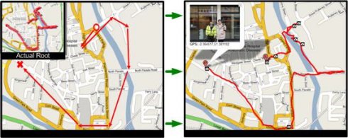
Sunset GPS Logger-allows you to capture your activities (walking, running, cycling, snowboarding, hiking trails .etc) for later visualisation on Google maps. Combined with your existing digital camera it becomes an indispensable tool to simplify the process of geo-tagging those precious photos and memories.

Installation Instructions:
1) Install the application by copying the cab file to your device via ActiveSync then running it on your device.
2) Ensure you have paired up a GPS receiver with your device and have assigned 'com7' as the outgoing devices com, for devices with a built in GPS ensure this is the GPS 'Hardware' port not programme port.
3) To start GPS logging select Menu -> Start GPS Trail.
4) To stop logging select Menu - > Stop GPS Trail.
5) You can find all your GPS logs in the following device directory 'Storage CardGPSLogs'.
6) International locale issue: If you live outside the UK to ensure GPX format compatibility please set you normal number format to the following (English: '.' For decimal and ',' as digit grouping).

Additional Notes: To GPS tag your photos: use the gpx log files in combination with Microsoft's WWMX Location Stamper or DGManager.NET Nb. For the best results ensure that BOTH your Mobile device and Digital cameras date/time settings are identical, as both rely heavily on date/time in GPS tagging your photos.


Like it? Share with your friends!

If you got an error while installing Themes, Software or Games, please, read FAQ.
 

Supported operating systems: Windows Mobile 5.0, Windows Mobile 6 Classic, Windows Mobile 6 Professional, Windows Mobile 6.1 Classic, Windows Mobile 6.1 Professional, Windows Mobile 6.5 Professional
 
Similar Software:

ExercisesGPSsExercisesGPSs
ExercisesGPSs - ExercisesGPSs uses the GPS on your PocketPC to measure your speed/walking/running speed. The program displays your speed in Km/h with 3-digit accuracy. NOTE: Use caution when exercising and using this program. This program requires that you have both the 'BeanDLL.dll' file ** and ** the runtime files for Visual Basic on your PocketPC computer
GPSRulererGPSRulerer
GPSRulerer uses GPS to find two points and uses the "The Vincenty inverse formula for ellipsoids." (accuracy to within 0.5mm, or 0.000015"). Select 'Start GPS' to start the GPS and when you get a lock you can view your current GPS. Tap the button to save it and measure your distance. The map service is provided by Google
DrinkGooglerDrinkGoogler
DrinkGoogler uses the GPS on your PocketPC to find the 50 closest local bars sorted via GPS distance. Tap the button to start the GPS and when you get a lock tap on it to view the list of local bars. You can also dial the bar. The GPS maps and business search service is provided by Google
MapWMMapWM
Record GPS data with your Windows Mobile device
GPSmeterGPSmeter
Do you still use your GPS device for navigating only? Turn your Pocket PC into a high precision metering machine using your GPS receiver! With MASPware GPSmeter you can measure short and long distances (beeline or routelength), altitude differences, timespans, average values and min-max-values using an internal or external GPS receiver
Mobile AltimeterMobile Altimeter
Mobile Altimeter  -Altimeter for windows mobile devices. We have a background that symbolizes "altitude" which is appealing to end users. Plus it gives the program a lot of style and class
FON Access Points for ColombiaFON Access Points for Colombia
FON Access Points for Colombia - FON offers you a new Points of Interest service (POIs). This allows you to download FONspots directly to your navigation device. What does that mean? You can download a Points of Interest file directly to your navigation device
OS GPS ConvertorOS GPS Convertor
OS GPS Convertor converts positions between WGS84 latitude & longitude and Ordnance Survey (OS) British & Irish or Universal Transverse Mercator (UTM) worldwide grid references. It displays positions in multiple formats. It can be used with:  * TomTom Navigator - to create a Point of Interest (POI) or Itinerary file ... then show on map, navigate to, etc
Navigation BE-ON-ROAD USA Q2/2011Navigation BE-ON-ROAD USA Q2/2011
Navigation BE-ON-ROAD USA Q2/2011 - The new major version of be-on-road presents new features and is based on new platform which brings high level of reliability, portability and speed on almost any kind of device. The new be-on-road brings high value voice guided door-to-door navigation
FON Access Points for KuwaitFON Access Points for Kuwait
FON Access Points for Kuwait - FON offers you a new Points of Interest service (POIs). This allows you to download FONspots directly to your navigation device. What does that mean? You can download a Points of Interest file directly to your navigation device
 

Comments on Sunset GPS Logger:

Comments not found

Name:


Comment:


Enter text from image below:

Turn on images!


If you noted an error or download link is broken, please, report it via this page or use comments.
 

Sunset GPS Logger is compatible with your device AnyDATA ASP-318
 
 
© Pantich 2009 - 2025 All rights reserved.