|
WinSportsTracker is an intuitive easy to use application with powerful capabilities for touch screen Windows mobile professional phones. It is for everyone who enjoy outdoor sport activities like running, cycling, skiing, sailing, riding, hiking, rollerblading...It logs your activity speed, distance, altitude, position and many more and show on dashboard, graph or map (up to 7 views). You can save track logs for later review or export on PC (view on Google Earth, etc). WinSportsTracker helps you to improve your performance in sports. It will not affect normal operation of your mobile phone during use.
Why buy expensive sport tracking gear if you can install FREE program on your windows mobile phone?
Main program features:
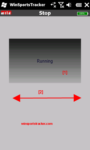
-Up to 7 different tracking views
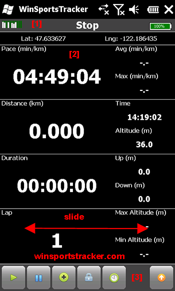
· Display speed, altitude, distance, duration, laps, calorie burn, laps statistics (current, average, max, graph display...)
· Upload to website winsportstracker.com. You can share workout with friends on Facebook
· Support different activities (running, cycling, skiing, riding, sailing,...)
· Off-road navigation. You can import route in GPX format and follow route (bearing or direction to selected point).
· Offline maps, you can download maps (OpenStreetMaps, Google maps,…) in advance on computer no need for internet connection on phone or data plan. Read FAQ on website how to download maps.
· GPX import track or route
· Activity (sport)dependent settings
· Auto lap, manual lap, lap sound
· Auto pause, manual pause, new lap on auto pause
· Add free defined way points
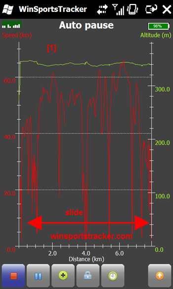
· Graphic display speed and altitude vs. time, altitude display relative or absolute
· Graphic display speed and altitude vs. distance, altitude display relative or absolute
· Track view on offline map (you do not need data plan on your phone)
· Measuring units: metric, imperial, nautical
· Slide display, scroll list
· Power management long battery life
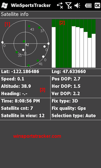
· GPS signal info (satellites, signal strength)
· Auto save track in case if battery runs out
· History of tracks
· Export track in GPX format (you can view track in Google Maps or some different app.)
· Translations
· Normal/full screen mode
· Supported resolutions: WVGA, VGA, square, WQVGA, QVGA, portrait and landscape orientations
What's New in This Release:
· Altitude display on map view
· Minimum battery settings
What's New in 3.17
· Greek translation
|
Similar Software:
|
 | Sorry I'm Late
Sorry I'm Late - People are always in a hurry to get somewhere. A common issue is to inform someone waiting for us that we are, let’s say, a bit late and maybe reassure him that we will be there in some time |  | Remove GPS Notify
Run this program to remove the GPS icon |  | FON Access Points for Lithuania
FON Access Points for Lithuania - FON offers you a new Points of Interest service (POIs). This allows you to download FONspots directly to your navigation device.
What does that mean? You can download a Points of Interest file directly to your navigation device |  | PMWGPSTracking
PMWGPSTracking allows you to plot your trip in a file (. KML).
The trace files can then be viewed and compared with Google Earth.
For each track you can define intermediate time (time stamp).
For each lap, the program calculates the duration, average speed and distance.
The trace files can be sent at regular intervals on an FTP server or an email address |  | GPS Tuner Essentials Full Version with Iberia Basic Map Content
GPS Tuner Essentials Full Version with Iberia Basic Map Content is designed specifically for off-road use: its large buttons, selectable tool window size, multiple Compass views and the built-in Tele Atlas map makes it extremely user-friendly and reliable |
|
 | GPS2Watch
GPS2Watch - Add-on for smartWatchM that displays GPS information on supported Bluetooth watches. It simply uses smartWatchM "3rd party notifications", and connects to WM5+'s intermediate GPS driver, so no messing with COM ports. It should work with any device/GPS combination, if the GPS is external it must be set in WM's "External GPS" settings |  | FON Access Points for Jamaica
FON Access Points for Jamaica - FON offers you a new Points of Interest service (POIs). This allows you to download FONspots directly to your navigation device.
What does that mean? You can download a Points of Interest file directly to your navigation device |  | Turbo GPS
Turbo GPS -The most flexible and precise track / offroad GPS you have seen. Available for both Windows and Windows Mobile |  | ppc PhotoGeoTag
ppc PhotoGeoTag - Take pictures with your mobile phone and incorporate the data of the geographical location. The application allows you to include in the photographs, data from the GPS receiver, along with a brief note. If you know the coordinates, not having the GPS receiver, you can also handwrite geographic data |  | TTSGpser
TTSGpser - TTSGpser uses text-to-speech to tell you the current GPS coordinates.
To use the app, simply run it, wait for the program to get a GPS lock, and then press the button to hear your location spoken in a female voice.
The application uses Google's TTS engine |
|
|


