Supported operating systems:
Windows Mobile 5.0, Windows Mobile 6 Classic, Windows Mobile 6 Professional, Windows Mobile 6.1 Classic, Windows Mobile 6.1 Professional
Similar Software:
Trippr Trippr - This application is part of the author's "30 Days of .NET" initiative to develop 30 mobile applications in 30 days. The source code of the application is included in order to help programmers new to Windows Mobile development write applications in .NET.
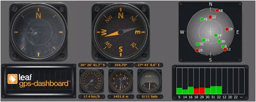
You've probably already figured out what this application does
GPSMaperer GPSMaperer is a full featured map downloader. You can enter the lat/long coordinates or use your current GPS to download a map. You can download in GIF, PNG or JPEG format. The program has several options to customize the map. The map service is provided by Google
TextGPSed TextGPSed - TextGPSed can be used to make text files with a GPS tag as the text file name. Each time you make a file the file is named the latitude and longitude of the file. You can store your files on the storage card. You can also view the text files with Google maps.
This program requires that you have both the 'BeanDLL
MapZIPed MapZIPed allows you to enter a US ZIP code and searches the USZIP.com website for the GPS information and places it into a downloadable map. You can also view the location on the Google.com maps service. This service is provided by USZIP
GPS Mod Driver GPS Mod Driver - This Driver installs between your GPS application and the GPSID driver that reads the hardware GPS data. Lag is compensated, by guessing your position 'some number' of milliseconds in the future, current course and speed changes are included in the guess
GeoTerrestrial GPSToday Now brings an unbeatable combination of location features to your mobile device
bLADE Locate bLADE Locate - A Fire Eagle client for Windows Mobile
Hotfix to enhance the internal GPS capability in the HTC Touch Pro2 Hotfix to enhance the internal GPS capability in the HTC Touch Pro2 - This hotfix can help the HTC Touch Pro2 seek out GPS satellites when using programs like TomTom, PAPAGO and others.
Copy the hotfix, which is an .exe file, to your device. To install the hotfix, tap the .exe file and follow the on-screen instructions
FON Access Points for Lebanon FON Access Points for Lebanon - FON offers you a new Points of Interest service (POIs). This allows you to download FONspots directly to your navigation device.
What does that mean? You can download a Points of Interest file directly to your navigation device
TwitsnapsMaps TwitsnapsMaps uses the GPS on your PocketPC to find your current latitude/longitude/speed and altitude and allows you to upload your position via map to Twitter.com. You can customize the maps zoom, and type via the 'Options' in the toolbar. The maps service is provided by Google.com. The map/Twitter storage is from TwitSnaps
Comments on GPS Dashboard:
Comments not found
If you noted an error or download link is broken, please, report it via this page or use comments.
GPS Dashboard is compatible with your device AnyDATA ASP-505A