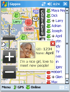
Gippos is mobile software for locating yourself and other users on the map and for instant messaging. Feel the city pace
Do you like to meet new people on the streets? Chat with them for free? Know where your friends are?
Meet and communicate without trouble! Enjoy nature
Arranging a picnic in a beautiful place? Inviting your friends for a country walk? Your friends will easily find you on a map!
· Find your friends on a map
· Meet new people around you
· Chat for free
What's New in This Release:
· Jabber protocol is used for messaging now.
· Jabber users from other servers can be added to contact list.
· Loading last messages to chat log window is added.
· Chat history viewing is added.
· Avatar loading is added.
· "About Gippos" info window is added.
· Maps switching logic is improved.
· Three modes of user's location visibility are implemented.
· New chat statuses are added.
· Gippos auto updating at new version release is added.
· "Don't turn the device off while the application is running" feature is implemented.
· Viewing user's location, history, and profile from chat window is added.
· Manually locating oneself on the map is added.
· Search window interface is changed
Like it? Share with your friends!
If you got an error while installing Themes, Software or Games, please, read FAQ.
Supported operating systems:
Windows Mobile 5.0, Windows Mobile 6 Classic, Windows Mobile 6 Professional, Windows Mobile 6.1 Classic, Windows Mobile 6.1 Professional, Windows Mobile 6.5 Professional
Similar Software:
Tube 2 Engine (Pocket PC) Tube 2 Engine (Pocket PC) - Transform your PDA into a fully scrollable detailed map of one of the worlds subway or metro systems.
See your journeys come alive with a superb animated display.
Save hours by automatically having the quickest routes to hand, with all the details you need including line changes, platform directions and accurate journey times
Speereo Voice Translator: English-Turkish (WM) Speereo Voice Translator (SVT) is an ideal companion for traveling on business or leisure and also is an excellent aid for business communication. Running on Windows Mobile and Symbian based mobile devices it contains of over 4000 phrases in each of 16+ languages and many other useful features
Travel Ireland - illustrated guide and maps. Incl: Dublin, Cork, Galway and more. FREE General Info Travel Ireland - illustrated guide and maps. Incl: Dublin, Cork, Galway and more. FREE General Info - An illustrated guide and maps. Indulge Yourself with a personal tour guide on Your PDA. FREE General Information chapter and a map in the trial version.
Features
Fully illustrated.
Historical overviews.
Interesting facts.
City Attractions
PrettyEarth PrettyEarth
View maps of Earth with PrettyEarth! See current day and night regions, learn geography by taking the quiz, enjoy relief elevation surfaces and measure distances between locations
Map of Milan / Italy for City Advisor Milan / Italy map for City Advisor. Includes all tube lines, all urban trains lines, all tramway lines, all bus lines and supports full timetables.
Instructions:
1. Download the map (zip file)
2. Extract the files in /CityAdvisor/maps
3. Open CityAdvisor -> Maps icon -> Menu -> Refresh
4
Map of Amiens (French) / France for City Advisor Map of Amiens (French) / France for City Advisor - A map of Amiens' bus transport for City Advisor. Contains line 1 to 11 with full timetable.
Instructions:
1. Download the map (zip file)
2. Extract the files in /CityAdvisor/maps
3. Open CityAdvisor -> Maps icon -> Menu -> Refresh
4
Free Earth Elevation Map for PrettyMap/PrettyEarth Earth Elevation Map for PrettyMap/PrettyEarth - This is a medium-resolution, free Earth elevation map for PrettyMap and PrettyEarth. It contains one elevation sample per 4 km, approximately.
Note: large file (16 MB download, 55 MB after installing).
Note for PrettyEarth users: this map will be installed to Program FilesPrettyMapmaps
MapFolderer MapFolderer uses GPS to find your current location and downloads a JPEG map of the area with a custom name. The maps are tagged with the GPS lat/lng on each JPEG file. You can also view the maps on the built in map viewer. The maps service is provided by Google
amAze (Samsung) AmAze is a first of its kind free navigation and local search service. It is free to download and use and it contains wide coverage of maps including aerial photo in Europe, North America, Australia and parts of Asia and Africa
Other Software by developer «Gippos»:
not found
Comments on Gippos:
Comments not found
If you noted an error or download link is broken, please, report it via this page or use comments.
Gippos is compatible with your device AnyDATA ASP-505A


")

")


 / France for City Advisor")


")