mdNavMobile is a waypoint-based GPS navigation solution for the Windows Mobile platform. It can guide you from waypoint to waypoint while keeping you informed of all relevant navigation data. All NMEA-data from a GPS is automatically logged to file so you can 'replay' a trip with variable speed.
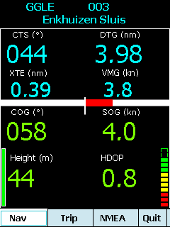
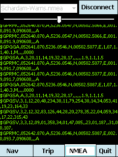
· GPS info: Latitude, Longitude, COG, SOG, Height, Satellites, HDOP and NMEA-stream
· Waypoint info: CTS, DTG, TTG, VMG, XTE
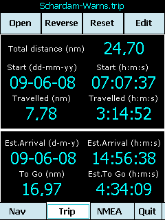
· Trip info: Total distance, Start, Travelled distance/time, DTG, TTG, ETA
· Reverse and Reset trips
· Scroll to next/previous waypoint
· Logs full NMEA stream from GPS to Storage Card
· Simulation using NMEA-log files with variable speed (factor 0.01-100)
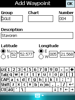
· Create/Edit Trips and Waypoints
· Show data in nm/kts/ft or km/kmh/m
· Change colors
· Trip-files also editable with notepad
· Totally free
Like it? Share with your friends!
If you got an error while installing Themes, Software or Games, please, read FAQ.
Supported operating systems:
Windows Mobile 5.0, Windows Mobile 6 Classic, Windows Mobile 6 Professional, Windows Mobile 6.1 Classic, Windows Mobile 6.1 Professional, Windows Mobile 6.5 Professional
Similar Software:
PoliceGPSes PoliceGPSes - PoliceGPSes can be used to track suspects that you are using the PocketPC PoliceGPSer's locator on. You can make a file for each group of locators and view the current latitude/longitude/speed and altitude of each GPS locator on the Google.com maps site.
This program requires that you have both the 'BeanDLL
Efficasoft GPS Utilities (Pocket PC) Efficasoft GPS Utilities for Pocket PC is the complete mobile GPS solution for Windows Mobile Pocket PC. It's the best companion for activities such as touring, hiking, geocaching... By defining a Go To list, you can even use it as a voice driving navigator!
· Designed GPS information overview.
· New! Voice "Go To" navigation function
PictureGPSed PictureGPSed - PictureGPSed checks the camera storage folder for new pictures/videos and when detected places the current GPS tag at the end of the image/video and sends it via email with a Google.com map link. You can also view the images via a distance file viewer. You can also view and download a map of the pictures from Google.com
Mobitee Lite Mobitee is a mobile application intended for both skilled and beginning golfers with the purpose to diversify the game and make it accessible simultaneously allowing to raise game level
FON Access Points for Guadaloupe FON Access Points for Guadaloupe - FON offers you a new Points of Interest service (POIs). This allows you to download FONspots directly to your navigation device.
What does that mean? You can download a Points of Interest file directly to your navigation device
MapFingerer MapFingerer - MapFingerer allows you use the GPS on your device or custom GPS values to download maps from Google.com and keeps them in a finger friendly database. You can make multiple pages for the maps. Tap on the map to button to view it.
This program requires that you have both the 'BeanDLL
FON Access Points for Luxembourg FON Access Points for Luxembourg - FON offers you a new Points of Interest service (POIs). This allows you to download FONspots directly to your navigation device.
What does that mean? You can download a Points of Interest file directly to your navigation device
FON Access Points for Uruguai FON Access Points for Uruguai - FON offers you a new Points of Interest service (POIs). This allows you to download FONspots directly to your navigation device.
What does that mean? You can download a Points of Interest file directly to your navigation device
Pocket PC Geocaching Tools Pocket PC Geocaching Tools - Many tools in one program to help you while you are geocaching.
What's included?
* Open GSAK databases directly
* HTML view
* Field Notes
* Hint decoder and decryption
* Several coordinate functions
* Solver
* Transformer (Text to Digits, etc
GPSAltimeterer GPSAltimeterer uses the GPS on your PocketPC to find your altitude. You can view in Meters or Feet. This can be used on a plane that does not allow full GPS. Start the program to find your height via GPS on it. NOTE: Make sure you are allowed to use this program before starting the application
Other Software by developer «Maurits Dijkens»:
not found
Comments on mdNavMobile:
Comments not found
If you noted an error or download link is broken, please, report it via this page or use comments.
mdNavMobile is compatible with your device AnyDATA ASP-505A


")


