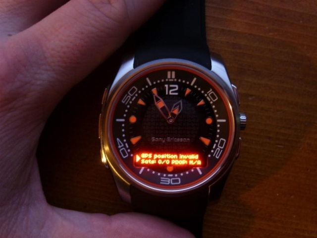
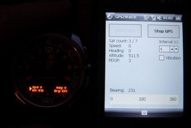
GPS2Watch - Add-on for smartWatchM that displays GPS information on supported Bluetooth watches. It simply uses smartWatchM "3rd party notifications", and connects to WM5+'s intermediate GPS driver, so no messing with COM ports. It should work with any device/GPS combination, if the GPS is external it must be set in WM's "External GPS" settings. Simply run the program, click "Start GPS", and the watch should start displaying GPS info, refreshed every 4 seconds (this seems to be the best choice to have a nearly continuous display, seeing how smartWatchM polls the text file). This results in only short blinks from the watch between screen updates.
The watch will display "GPS Position Invalid" when used sats < 3 or PDOP > 10. In normal display, the display shows Speed, alt, heading and a user settable bearing.
· GPS speed, alt, heading display
· User settable bearing
· User-definable update rate, min 4 seconds
· Watch vibration on/off
· Uses WM5+ GPS driver, so make sure "External GPS" settings are correct (DON'T touch if you use an internal GPS)
Like it? Share with your friends!
If you got an error while installing Themes, Software or Games, please, read FAQ.
Supported operating systems:
Windows Mobile 5.0, Windows Mobile 6 Classic, Windows Mobile 6 Professional, Windows Mobile 6.1 Classic, Windows Mobile 6.1 Professional, Windows Mobile 6.5 Professional
Similar Software:
TaxGoogler TaxGoogler uses the GPS on your PocketPC to find the 50 closest tax services sorted via GPS distance. Tap the button to start the GPS and when you get a lock tap on it to view the list of tax services. You can also dial the shop. The GPS maps and tax search service is provided by Google
mdNavMobile mdNavMobile is a waypoint-based GPS navigation solution for the Windows Mobile platform. It can guide you from waypoint to waypoint while keeping you informed of all relevant navigation data. All NMEA-data from a GPS is automatically logged to file so you can 'replay' a trip with variable speed
amAze (Sony Ericsson) AmAze is a first of its kind free navigation and local search service. It is free to download and use and it contains wide coverage of maps including aerial photo in Europe, North America, Australia and parts of Asia and Africa
GPSAltimeterer GPSAltimeterer uses the GPS on your PocketPC to find your altitude. You can view in Meters or Feet. This can be used on a plane that does not allow full GPS. Start the program to find your height via GPS on it. NOTE: Make sure you are allowed to use this program before starting the application
Pocket PC Geocaching Tools Pocket PC Geocaching Tools - Many tools in one program to help you while you are geocaching.
What's included?
* Open GSAK databases directly
* HTML view
* Field Notes
* Hint decoder and decryption
* Several coordinate functions
* Solver
* Transformer (Text to Digits, etc
AccountingGPS AccountingGPS - Each sheet has the GPS home setting and you can use the GPS on your PocketPC to view the distance of every sheet. Select the sheet to view/edit the entry for it. You can also view a Google.com map of your current or the sheets GPS
SatTracx Mobile Locator SatTracx Mobile Locator helps to know your location or the whereabouts of your family, friends or your assets at anytime.
You can locate your loved ones – your children, elderly or patients at any given moment. You can also find where your buddies are and connect with them
GPS Tuner Atlas Full Version with Full Europe Basic Map Content GPS Tuner Atlas Full Version with Full Europe Basic Map Content is designed specifically for off-road use: its large buttons, selectable tool window size, 6 different types of Compass views and the built-in Tele Atlas map makes it extremely user-friendly and reliable
MapSpeedometers MapSpeedometers - MapSpeedometers uses the GPS on your PocketPC to measure your speed in and says it in a computerized voice at an interval that you select. You can select Miles/Km/h and Nautical Miles and the program will repeat the speed-reading at the selected interval.
This program requires that you have both the 'BeanDLL
TrekBuddy Trekbuddy is a J2ME application to be used with a GPS receiver. It is designed to work with every Java-enabled device. It features capabilities such as: * GPS tracking and simple navigation * bitmap maps (without zoom, you can store bitmap maps with different resolution instead)
Other Software by developer «kilrah»:
not found
Comments on GPS2Watch:
Comments not found
If you noted an error or download link is broken, please, report it via this page or use comments.
GPS2Watch is compatible with your device AnyDATA ASP-518


")


