mdNavMobile is a waypoint-based GPS navigation solution for the Windows Mobile platform. It can guide you from waypoint to waypoint while keeping you informed of all relevant navigation data. All NMEA-data from a GPS is automatically logged to file so you can 'replay' a trip with variable speed.
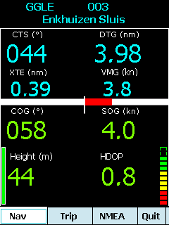
· GPS info: Latitude, Longitude, COG, SOG, Height, Satellites, HDOP and NMEA-stream
· Waypoint info: CTS, DTG, TTG, VMG, XTE
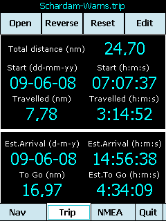
· Trip info: Total distance, Start, Travelled distance/time, DTG, TTG, ETA
· Reverse and Reset trips
· Scroll to next/previous waypoint
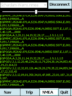
· Logs full NMEA stream from GPS to Storage Card
· Simulation using NMEA-log files with variable speed (factor 0.01-100)
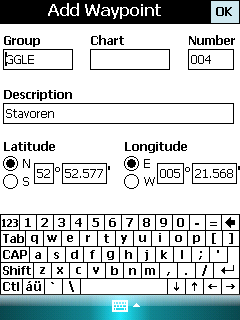
· Create/Edit Trips and Waypoints
· Show data in nm/kts/ft or km/kmh/m
· Change colors
· Trip-files also editable with notepad
· Totally free
Like it? Share with your friends!
If you got an error while installing Themes, Software or Games, please, read FAQ.
Supported operating systems:
Windows Mobile 5.0, Windows Mobile 6 Classic, Windows Mobile 6 Professional, Windows Mobile 6.1 Classic, Windows Mobile 6.1 Professional, Windows Mobile 6.5 Professional
Similar Software:
TextsGPS TextsGPS - TextsGPS can be used to make text notes with a GPS tag as the text file name. You can store your files on the storage card. You can also view the text entries with Google maps.
This program requires that you have both the 'BeanDLL.dll' file ** and ** the runtime files for Visual Basic on your PocketPC computer
FacebookGPS FacebookGPS allows you to update your status on FaceBook with a GPS link to a Google.com mobile map. Tap the button to get a GPS lock. Once you have a lock enter your status update and your FaceBook.com status will be updated with a link to the Google.com Mobile maps. This service is provided by FaceBook
SIGLOG SIGLOG - A Windows Mobile application that logs latitude, longitude, signal strength, mobile country code, mobile network code, location area code, CellID.
Written in Win32 C++ it's lean, mean, rather basic, but it does the job. It requires a phone with GPS, as it calls the Microsoft intermediate GPS driver
myRadar myRadar is a location aware radar application that makes use of Wunderground and Accuweather US web services to show real-time, animated Radar Images of your local area regardless of where in the US you might be. This application requires myLocation services to function automatically.
The program will install to /Program Files/myRadar
FON Access Points for Fiji FON Access Points for Fiji - FON offers you a new Points of Interest service (POIs). This allows you to download FONspots directly to your navigation device.
What does that mean? You can download a Points of Interest file directly to your navigation device
GPS Speedometer GPS Speedometer displays an attractive dash with both digital and analog display using GPS
SmartProtect SmartProtect helps you track and recover your phone once stolen or lost.
Features includes:
1. A Thief or Lost Prevention Software with SMS Auto-Responder and GPS Capability created for Windows Mobile Devices.
2
GPSRulerer GPSRulerer uses GPS to find two points and uses the "The Vincenty inverse formula for ellipsoids." (accuracy to within 0.5mm, or 0.000015"). Select 'Start GPS' to start the GPS and when you get a lock you can view your current GPS. Tap the button to save it and measure your distance. The map service is provided by Google
CellMapper (Windows Mobile) CellMapper is a Windows Mobile application which is used to help map the extent of cell phone towers coverage. The program records the location, using built-in GPS, and the cell phone tower signal and information at that location
FON Access Points for Palau FON Access Points for Palau - FON offers you a new Points of Interest service (POIs). This allows you to download FONspots directly to your navigation device.
What does that mean? You can download a Points of Interest file directly to your navigation device
Other Software by developer «Maurits Dijkens»:
not found
Comments on mdNavMobile:
Comments not found
If you noted an error or download link is broken, please, report it via this page or use comments.
mdNavMobile is compatible with your device AnyDATA ASP-518


")
