You don't know where you parked your car anymore? Have you ever wondered how far your are away from home and in what direction it is? GpsSpot from Cradle Software shows you in what direction and how far a previously saved spot is.
Using GpsSpot you can easily save any location and using the build-in or attached GPS device the application will show you at what distance and in what direction the saved spot is. For your better recognition of the target you can also save an image with every spot. Without any difficulties you will find every saved spot again, like your parking space, your bicycle in front of yesterdays bar, the next cash machine or bus stop.
Finger-friendly handling
The application's intuitive user interface can be comfortable operated with your finger.
Your current location can be added with just three finger taps.
Picture support
You can take a picture with the camera of your device or select an existing image to assign it to your saved spot.
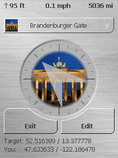
Display
The application shows the distance to the selected spot, the current altitude and the current speed. As basic unit meters or miles/feet can be selected.
High contrast mode
You can activate the "high contrast mode" for a good perceptibility of the direction arrow even on bright day light.
Support
A detailed help file is included in the application, which thanks to the intuitive user interface is rarely needed.
Of course we always provide support by eMail if you have any problems or questions.
Multilingual
The following languages are included with the application:
English, German, Turkish
Windows Mobile 5.x and 6.x
The application runs on every Windows Mobile Professional device (with touchscreen and Windows Mobile 5.0 and up) and supports all existing screen resolutions and alignments like portrait, landscape or quadratic displays.
In addition only a build-in or attached GPS device is needed.
Certified by Microsoft
The application is available at the Windows Mobile Marketplace and therefore certified by Microsoft through multiple tests. That way a good stability and Windows Mobile compatibility is guaranteed.
Free download
Download the free trial version now (the trial version does not allow to add any new spots - hence it is only possible to get the distance and direction to the preset locations).
If you like the application you can buy a registration code and change the already installed program into a full version.
Like it? Share with your friends!
If you got an error while installing Themes, Software or Games, please, read FAQ.
Supported operating systems:
Windows Mobile 5.0, Windows Mobile 6 Classic, Windows Mobile 6 Professional, Windows Mobile 6.1 Classic, Windows Mobile 6.1 Professional, Windows Mobile 6.5 Professional
Similar Software:
FON Access Points for Algeria FON Access Points for Algeria - FON offers you a new Points of Interest service (POIs). This allows you to download FONspots directly to your navigation device.
What does that mean? You can download a Points of Interest file directly to your navigation device
FON Access Points for North Korea FON Access Points for North Korea - FON offers you a new Points of Interest service (POIs). This allows you to download FONspots directly to your navigation device.
What does that mean? You can download a Points of Interest file directly to your navigation device
uTrack uTrack - uTrack can be used to track mobile devices in a passive, non-intrusive way.
It can be used to publish the location of a Windows Mobile powered device to a widget that can be included in numerous websites including you're own. If a widget is not possible or more flexibility is required, uTrack can also be configured to publish directly to any website or webservice
FON Access Points for Liechtenstein FON Access Points for Liechtenstein - FON offers you a new Points of Interest service (POIs). This allows you to download FONspots directly to your navigation device.
What does that mean? You can download a Points of Interest file directly to your navigation device
OS GPS Convertor OS GPS Convertor converts positions between WGS84 latitude & longitude and Ordnance Survey (OS) British & Irish or Universal Transverse Mercator (UTM) worldwide grid references. It displays positions in multiple formats.
It can be used with:
* TomTom Navigator - to create a Point of Interest (POI) or Itinerary file ... then show on map, navigate to, etc
Mologogo Mologogo is a free service that will track you and your friends using GPS-enabled mobile phones.
From your phone or the web, Mologogo shows you where you and your friends are at any moment. If you are on the go, Mologogo can alert you when friends are close, search around for points of interest, and keep you updated with local traffic and weather
MyMotion MyMotion - GPS route recording and playback with customizable spoken feedback of speed, distance and time. Uses a moving map to show progress as well as textual output. Maps can be generated from Google Earth installed on a PC using a map creation tool. Allows user to record a route then load it up as a reference for live comparison the next time it is traversed
FON Access Points for Switzerland FON Access Points for Switzerland - FON offers you a new Points of Interest service (POIs). This allows you to download FONspots directly to your navigation device.
What does that mean? You can download a Points of Interest file directly to your navigation device
GPS.Friend GPS.Friend - This is user-friendly program,
allows you, with just two touches of your phone:
- get and review your current geographic location
- request someone's phone to give you his/her location
- review on the map your and someone's location.
You needn't know GPS, you needn't learn too much, about this program
Other Software by developer «Cradle Software»:
CradleAlarm CradleAlarm
CradleAlarm supersedes the poorly featured alarm clock of Windows Mobile. With this application you can set multiple alarms, that provide a large number of settings to let you start your day as pleasant as possible, to remind you of an appointment or many more