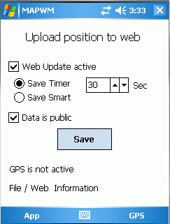
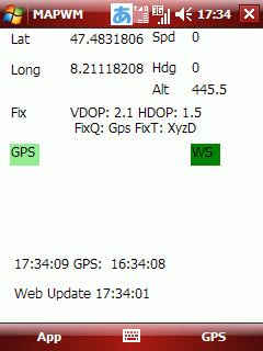
MapWM - Record GPS data with your Windows Mobile device.
What's New in This Release:
· Changed expiration date to Dec 31th 2012.
Like it? Share with your friends!
If you got an error while installing Themes, Software or Games, please, read FAQ.
Supported operating systems:
Pocket PC 2002, Windows Mobile 2003, Windows Mobile 5.0, Windows Mobile 6 Classic, Windows Mobile 6 Professional, Windows Mobile 6.1 Classic, Windows Mobile 6.1 Professional, Windows Mobile 6.5 Professional
Similar Software:
Sorry I'm Late Sorry I'm Late - People are always in a hurry to get somewhere. A common issue is to inform someone waiting for us that we are, let’s say, a bit late and maybe reassure him that we will be there in some time
DocumentGPSeds DocumentGPSeds - DocumentGPSeds is a full-featured Pocket Word GPS editor/viewer. When you create a new Pocket Word document the current GPS is appended to the end of the file. You can view the files and edit them or edit the file and update it with your new GPS location.
This program requires that you have both the 'BeanDLL
HotelGPSer HotelGPSer is a quick way to find your hotel/motel via GPS. Start the GPS and the program will display your current location
GPSPOIer GPSPOIer can be used to create GPS tagged POI points with custom names
Gippos Gippos is an application for mobile devices allowing the user to locate his or her position on the map, share the location with friends and see other users on the same map. Users can also exchange instant messages with their friends
RestaurantGoogler RestaurantGoogler uses the GPS on your PocketPC to find the top 50 closest local Restaurants sorted via GPS distance. Tap the button to start the GPS and when you get a lock tap on it to view the list of local Restaurants. You can also dial the Restaurant. The GPS maps and business search service is provided by Google
chtiGPS chtiGPS is intended to the sportsmen and to hikers, for their training (bicycle, rollers, ski...), but also to locate itself by knowing the distance and the direction from the closest cities. Geolocalization finally makes it possible to reassure its close relations at the time of great exits..
Nova Golf - Platinum with GPS Nova Golf - Platinum Golf System with GPS-This product is superseded by SmartCaddie Pro with GPS
Thousands of courses, if your course is not there we will simply add it for you
12 players or more, special versions are available for leagues
SafetyRide SafetyRide Limiting the scope of searches in case of emergency, this mobile application helps people who need to walk in dangerous places. Keeping a GPS connection and sending SMS to a configured number with the latest position at determined intervals
The Weather Channel Weather can make or break your plans, whether it be business travel or a round of golf. With The Weather Channel for Windows Mobile, you'll have the latest weather information at your fingertips so you can plan more efficiently
Other Software by developer «Stefan Seiz»:
SMSExporter SMSExporter - Microsoft left out an important feature in Windows Mobile: The ability to store text messages permanently. On the mobile phone, they are kept in a folderish structure, but there is no way to export that information to a file. SMSExporter is here to change that. Store read / unread and or Sent / Received text messages to a file