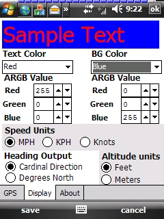
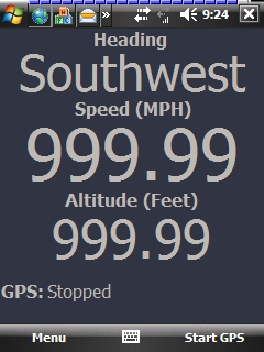
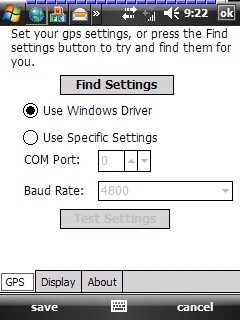
GudenSoft GPS Info An application which shows information from the GPS receiver. It uses both, the Windows Driver, and OpenNETCF's library, so if you have a GPS device, and a Windows Mobile Device, this should work
Like it? Share with your friends!
If you got an error while installing Themes, Software or Games, please, read FAQ.
Supported operating systems:
Windows Mobile 5.0, Windows Mobile 6 Classic, Windows Mobile 6 Professional, Windows Mobile 6.1 Classic, Windows Mobile 6.1 Professional, Windows Mobile 6.5 Professional
Similar Software:
gpsVP gpsVP works on virtually any Windows platform including mobile ones. It shows vector and raster maps, records and shows tracks, shows multiple navigation parameters, manages and shows waypoints. It aims to be as usable as possible.
What's New in This Release:
· Geoid correction matrix: Updated values Atlantic & east America's
PathAway GPS SE PathAway GPS SE - GPS Navigation using your own maps! Convert any digital map, for use on your Pocket PC. Then, attach a compatible GPS (via bluetooth, cable, snap-on, or card) to your handheld, and you have a powerful GPS Moving Map navigation system
amAze (Samsung) AmAze is a first of its kind free navigation and local search service. It is free to download and use and it contains wide coverage of maps including aerial photo in Europe, North America, Australia and parts of Asia and Africa
Fusion GPS Fix Fusion GPS Fix - FusionGPSFix tries to deal with the anemic GPS on the Raphael, and any other post-WM5 device with slow GPS locking.
This app runs after install, and after soft-reset, and immediately starts up the GPS hardware through the WM5+ GPS API. It waits 5 minutes for a GPS lock, or it quits
GPS Tuner Essentials Full Version with United States Basic Map Content GPS Tuner Essentials Full Version with United States Basic Map Content is designed specifically for off-road use: its large buttons, selectable tool window size, multiple Compass views and the built-in Tele Atlas map makes it extremely user-friendly and reliable
Gpx2rt2 Set of programs to convert GPS-tracks of *.gpx, *.mps, *.plt or *.nmea format to route files *.rt2
gpsVP gpsVP - GPS navigation software for Windows Mobile devices. It shows vector and raster maps, records and shows tracks, shows multiple navigation parameters, manages and shows waypoints. It aims to be as usable as possible
FON Access Points for Mauritius FON Access Points for Mauritius - FON offers you a new Points of Interest service (POIs). This allows you to download FONspots directly to your navigation device.
What does that mean? You can download a Points of Interest file directly to your navigation device
BackCountry Navigator BackCountry Navigator is fun-filled navigation software for the outdoor adventurer. Use it in a variety of outdoor adventures, from kayak touring to geocaching. This is a summary of what you can do with the product.
BackCountry uses free topo and aerial maps for the United States, downloaded directly from Terraserver-USA
GPS Tuner Essentials Full Version with Germany, Austria, Switzerland Basic Map Content GPS Tuner Essentials Full Version with Germany, Austria, Switzerland Basic Map Content is designed specifically for off-road use: its large buttons, selectable tool window size, multiple Compass views and the built-in Tele Atlas map makes it extremely user-friendly and reliable
Other Software by developer «GudenSoft»:
Email Scheduler Email Scheduler is a simple service program for Windows Mobile Devices that will automatically change your email polling settings. This means that just like ActiveSync, you can now have a schedule for all of your email accounts to check for messages
Email Scheduler Email Scheduler is a simple service program for Windows Mobile devices that will automatically change your email polling settings. This means that just like ActiveSync, you can now have a schedule for all of your email accounts to check for messages
RadarLove! RadarLove is a simple Radar image engine that pulls all the image data from the National Weather Service RIDGE system, including most of the overlays.
A few pointers:
* you can click on a location, and it will zoom in on that location. When you do this, the map must not move, otherwise the zoom will not work


")


