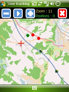
Mobbyway - Based on both internet mobile technologies and GPS, Mobbyway allows you to know easily, at any time, your relatives’ exact position on a map if they have accepted it and if they are connected to the network.
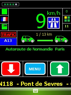
Mobbyway is also a help on the road network with a local alert system of a dangerous zone which is carried out with the network of members. Finally, Mobbyway will reference all the fixed radars in the countries where it is used and Mobbyway will indicate them to you.
Mobbyway was developed to allow:
- you to stay connected with your relatives wherever they are.
- your relatives to follow you visually and in real time.
- you to go back at any time to a place where you have already been on a specific date.
- you to travel safely on the road network thanks to the network members: The Mobbynautes.
- you to have a part in the world cartography OpenStreet Map
Like it? Share with your friends!
If you got an error while installing Themes, Software or Games, please, read FAQ.
Supported operating systems:
Windows Mobile 6 Classic, Windows Mobile 6 Professional, Windows Mobile 6.1 Classic, Windows Mobile 6.1 Professional, Windows Mobile 6.5 Professional
Similar Software:
uTrack uTrack - uTrack can be used to track mobile devices in a passive, non-intrusive way.
It can be used to publish the location of a Windows Mobile powered device to a widget that can be included in numerous websites including you're own. If a widget is not possible or more flexibility is required, uTrack can also be configured to publish directly to any website or webservice
Google Navigator Google Navigator is the most powerful and easy to use GPS navigation software on your Pocket PC. Also is the best and most easy to use and convenient software on your Pocket PC. All map data is transferred from Google via network, and save permanently on your device until you want to delete it
BlueWave GPS Displays GPS navigational information for boating
RestaurantGoogler RestaurantGoogler uses the GPS on your PocketPC to find the top 50 closest local Restaurants sorted via GPS distance. Tap the button to start the GPS and when you get a lock tap on it to view the list of local Restaurants. You can also dial the Restaurant. The GPS maps and business search service is provided by Google
RulerGPSer RulerGPSer - RulerGPSer uses the GPS on your PocketPC to view and download GPS marked satellite camera pictures and calculates distance between two points specified by the latitude/longitude of your GPS using "The Vincenty inverse formula for ellipsoids." (accuracy to within 0.5mm, or 0.000015")
This program requires that you have both the 'BeanDLL
SmartCaddie Pro SmartCaddie Pro with GPS
Thousands of courses, if your course is not there we will simply add it for you
12 players or more, special versions are available for leagues.
Includes enrolment for one user in the Nova Golf Internet Network (NGIN) providing further features and functions
CoffeeGoogler CoffeeGoogler uses the GPS on your PocketPC to find the 50 closest coffee shops sorted via GPS distance. Tap the button to start the GPS and when you get a lock tap on it to view the list of local coffee shops. You can also dial the store. The GPS maps and coffee search service is provided by Google
TravelGoogling TravelGoogling allows you to use the GPS on your PocketPC to find 5,451 local stores and services in sorted via distance. Tap the button to start the GPS and when you get the lock tap the button to view the business directory. Tap on a business category to view local business listings. The GPS street information is from GeoNames
FON Access Points for Puerto Rico FON Access Points for Puerto Rico - FON offers you a new Points of Interest service (POIs). This allows you to download FONspots directly to your navigation device.
What does that mean? You can download a Points of Interest file directly to your navigation device
Map4Fun Taipei-GPS Map4Fun Taipei-GPS - Going to Taipei? just download it for free!
Attractions and shops/hotels/restaurants... in Taipei... find coupons/POI instant video/communication links...on hand, and much more of major Asian cities at Map4fun.
1. Taipei Information.
2. Useful numbers.
3. Tourist attraction.
4. East Taipei area map.
5. Jhonshan area map.
6. Sinyi area map
Other Software by developer «Mobbyway»:
Mobbyway Mobbyway based on both internet mobile technologies and GPS, Mobbyway allows you to know easily, at any time, your relatives’ exact position on a map if they have accepted it and if they are connected to the network.Mobbyway is also a help on the road network with a local alert system of a dangerous zone which is carried out with the network of members


")
")