Barcelona Metro 10 - This Zuti application contains a visually unique map of the Barcelona transport system and a superb animated journey planner to help you get around the TMB (Transports Metropolitan de Barcelona), FGC (Ferrocarrils de la Generalitat de Catalunya) Metro and Tram services. Also included are airport transfer and leisure transportation such as the cable cars and Tramvia Blau bus service. Now revised and updated to include the new TMB L10 line and L9 extension.
MAP
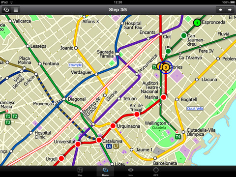
Unlike old fashioned schematic style maps this product contains a geographically accurate central area showing major streets, parks, places of interest, etc, allowing the user to easily get their bearings in the city. You can also use your inbuilt GPS to accurately locate and track yourself within the city centre and see the nearest transportation stop and distance to it. This is the only pubic transportation route planner with this ability. Tap on the map for location information, use the inbuilt search feature or choose from a list of locations. Places of interest, museums, hotels, parks, restaurant, shops, hospitals, streets, etc, are also included. The route planner will automatically suggest the nearest station to any place of interest you select. No internet connection is required for any of this functionality.
MINUTE MAP
Another great feature is the “Minute Map” option which allows you to see the travel times from a start point to all other locations on the map. This is a unique way to view the topology of a city and gauge traveling times.
ROUTING
The application does not require an internet connection and will always be available to display a clear and detailed view of the city transport systems, plus list and animate the optimum route for your journey. This product provides the fastest route calculations of any mobile routing application (virtually instantaneous) using actual published journey times with the ability to select the quickest route or the route with the least changes.
What's New in This Release:
· Improved user interface.
· Save and recall favourite routes.
· Instant Minute Map from any tap location.
· Show any transport service drawn on the map.
· Minor map updates.
Like it? Share with your friends!
If you got an error while installing Themes, Software or Games, please, read FAQ.
Supported operating systems:
Apple iOS 10.x (iPad), Apple iOS 11.x (iPad), Apple iOS 12.x (iPad), Apple iOS 4.2.x (iPad), Apple iOS 4.3.x (iPad), Apple iOS 5.0 (iPad), Apple iOS 6.0 (iPad), Apple iOS 7.0 (iPad), Apple iOS 8.x (iPad), Apple iOS 9.x (iPad), Apple iPhone OS 3.2.x (iPad)
Similar Software:
Lufthansa for iPhone Lufthansa for iPhone - The Lufthansa app turns your iPhone into a handy travel assistant.
With it, you can book Lufthansa flights from your mobile, check flight status, view the timetable and check in.
In addition, the application allows you to quickly access your personal travel details and your Miles & More account
Tyne & Wear Metro by Zuti Tyne & Wear Metro by Zuti - The new Tyne & Wear Metro map makes it easy to travel in and around the city using the Nexus Metro system. Unlike old fashioned schematic style maps this product contains a geographically accurate central area showing major streets, parks and places of interest etc, allowing the user to easily get their bearings
Bangkok Maps Bangkok Maps - software that helps you download and store the travel maps and plans you need. This super-handy app lets you download publicly available maps and store them on your iPhone or iPod Touch. You can download the maps when you have fast wifi connection - and then use any time in the future without delay
Lufthansa for iPad Lufthansa for iPad - The Lufthansa app turns your iPad into a handy travel assistant.
With it, you can book Lufthansa flights from your mobile, check flight status, view the timetable and check in.
In addition, the application allows you to quickly access your personal travel details and your Miles & More account
Virginia Wine In My Pocket Virginia Wine In My Pocket - According to the Travel Channel, "Virginia is carving its own niche in the little black books of savvy wine lovers searching for the next big thing."
Virginia Wine in My Pocket is a guide for travelers in Virginia wine country
iBART Live iBART Live From the makers of the acclaimed iBART, iBART Live is an intelligent transit application for Bay Area Rapid Transit. It is essential to all BART riders — from the occasional to the daily, the tourist to the commuter
TransitGuru Halifax The only transit app that combines with offline schedule, system maps, multiple transit types (train or bus) or agencies for single metro area, alarm to wake you up when arrival, and integration with Yelp and Map
Free & Frugal Paris Free & Frugal Paris - There is no need to spend your life savings to enjoy Paris. Visiting Notre Dame? Skip the overpriced tourist cafes and picnic by the Seine. Interested in Parisian history? Visit the gorgeous Musee Carnavalet - it's free
Tucson & the Old Southwest Tucson & the Old Southwest - Indian lands, Spanish colony, Mexican outpost, wild western American territory and finally the State of Arizona - the history of the lands surrounding the 'Old Pueblo' makes for fascinating diversity and exciting exploration. Saguaro-studded desert to riverine canyons to pine-topped mountains - the geography is equally as diverse
TripIt No Ads for iPhone/iPad TripIt No Ads for iPhone/iPad - TripIt is is a useful app which organizes your travel plans into an itinerary that has all the details of your trip in one place. Simply forward airline, car rental, hotel and restaurant reservations to TripIt, and you will be able to access them from anywhere
Other Software by developer «Visual IT»:
Tube 2 Paris (Palm OS) Tube 2 Paris (Palm OS) - This map package for Tube 2 consists of a fully scrollable detailed map of the Paris metro and RER system.
Plan journeys on this system, list details of the quickest routes and see a superb animated display of your journey tracking around the system map.
A Pro version is also available with integrated high quality street maps of central Paris
Tube 2 Barcelona (UIQ) Tube 2 Barcelona (UIQ) - This map package for Tube 2 consists of a fully scrollable detailed map of the Barcelona metro & rail system.
Plan journeys on the metro system, list details of the quickest routes and see a superb animated display of your journey tracking around the system map
Washington Metro for iPad by Zuti Washington Metro for iPad by Zuti - The new Washington Metro 10 map makes it easy to travel in and around the city using the WMATA Metro, MARC and VME systems. Also included are the Potomac river taxi routes and the DC Circulator bus routes
Tube 2 Miami (UIQ3) Tube 2 Miami (UIQ3) - This map package for Tube 2 consists of a fully scrollable detailed map of the Miami metro & rail system.
Plan journeys on this system, list details of the quickest routes and see a superb animated display of your journey tracking around the system map
Tube 2 Paris (UIQ) Tube 2 Paris (UIQ) - This map package for Tube 2 consists of a fully scrollable detailed map of the Paris metro and RER system.
Plan journeys on this system, list details of the quickest routes and see a superb animated display of your journey tracking around the system map
GB Major Road Atlas (Palm OS) GB Major Road Atlas (Palm OS) - This map package is an essential addition to your Tube 2 maps if you drive in and around Great Britain.
This reference map gives you a clear view of all the major roads in the whole of Great Britain, you can use the quick find feature to locate any of the 30,000 + GB towns and villages in the database
Rome Metro 10 for iPad Rome Metro 10 -The Zuti Rome Metro application is a superb geographically based map and route planner for the Metro, Tram, Urban and Regional rail systems. Unlike old fashioned schematic style maps this product contains a geographically accurate central area showing major streets, parks and places of interest etc, allowing the user to easily get their bearings
Tube Toronto (Series 60) Tube Toronto (Series 60) - Our highly acclaimed Tube application that guides you around the subway system of Toronto is now available for your Series 60 Symbian powered phone. An essential addition to your phone for locals and tourists alike.
· A detailed clear colour map of the transport system fully scrollable.
· Quick find station utility
Rough Guides Map Paris Rough Guides Map Paris... These guides are a series of fantastic interactive maps.
Produced in conjunction with the premier travel publisher Rough Guides.
Discover and explore Paris using full colour interactive linked maps, in this simple to use PDA version of The Rough Guides Paris
TUBE 2 New York City (Blackberry) TUBE 2 New York City (Blackberry)
Tube 2 New York City
Transform your Blackberry into a fully scrollable detailed map of the New York City MTA subway system.
Plan journeys on the New York City subway system, have the quickest routes to hand, with all the details you need including line changes, platform directions and accurate journey times


")
")

")
")
")

")

")