Barcelona Metro 10 - This Zuti application contains a visually unique map of the Barcelona transport system and a superb animated journey planner to help you get around the TMB (Transports Metropolitan de Barcelona), FGC (Ferrocarrils de la Generalitat de Catalunya) Metro and Tram services. Also included are airport transfer and leisure transportation such as the cable cars and Tramvia Blau bus service. Now revised and updated to include the new TMB L10 line and L9 extension.
MAP
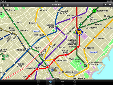
Unlike old fashioned schematic style maps this product contains a geographically accurate central area showing major streets, parks, places of interest, etc, allowing the user to easily get their bearings in the city. You can also use your inbuilt GPS to accurately locate and track yourself within the city centre and see the nearest transportation stop and distance to it. This is the only pubic transportation route planner with this ability. Tap on the map for location information, use the inbuilt search feature or choose from a list of locations. Places of interest, museums, hotels, parks, restaurant, shops, hospitals, streets, etc, are also included. The route planner will automatically suggest the nearest station to any place of interest you select. No internet connection is required for any of this functionality.
MINUTE MAP
Another great feature is the “Minute Map” option which allows you to see the travel times from a start point to all other locations on the map. This is a unique way to view the topology of a city and gauge traveling times.
ROUTING
The application does not require an internet connection and will always be available to display a clear and detailed view of the city transport systems, plus list and animate the optimum route for your journey. This product provides the fastest route calculations of any mobile routing application (virtually instantaneous) using actual published journey times with the ability to select the quickest route or the route with the least changes.
What's New in This Release:
· Improved user interface.
· Save and recall favourite routes.
· Instant Minute Map from any tap location.
· Show any transport service drawn on the map.
· Minor map updates.
Like it? Share with your friends!
If you got an error while installing Themes, Software or Games, please, read FAQ.
Supported operating systems:
Apple iOS 10.x (iPad), Apple iOS 11.x (iPad), Apple iOS 12.x (iPad), Apple iOS 4.2.x (iPad), Apple iOS 4.3.x (iPad), Apple iOS 5.0 (iPad), Apple iOS 6.0 (iPad), Apple iOS 7.0 (iPad), Apple iOS 8.x (iPad), Apple iOS 9.x (iPad), Apple iPhone OS 3.2.x (iPad)
Similar Software:
Canberra Bus Canberra Bus is a friendly timetable application that provides bus timetable for Canberra bus transport commuters. If you need an application to keep track of your favorite bus timetables throughout Canberra then this is for you!
· Access to all timetables in Canberra, Australia.
· Save and remove favorite routes at the touch of a button
Philadelphia Maps Philadelphia Maps - software that helps you download and store the travel maps and plans you need. This super-handy app lets you download publicly available maps and store them on your iPhone or iPod Touch. You can download the maps when you have fast wifi connection - and then use any time in the future without delay
London Central Bus 10 London Central Bus 10 - The new Zuti London Bus map has finally arrived, making it easy to travel by bus anywhere in central London. This clear and colourful map covers a detailed street level area of 6 miles by 4 miles and includes over 1300 bus stops and 189 bus routes
Short Trips Around Houston Short Trips Around Houston - GPSmyCity.com's day trips and weekend getaways appliaction is a powerful tool for planning a weekend away from the city. With a well researched list of getaway spots around the city you live in, you can explore natural wonders, regional history, and small town charm within a short drive from your home
Fuerth World Travel Fuerth World Travel - Map with locate me function makes you free to move.
Background reading always accompanies you on your trip
London City Maps Lite London City Maps Lite - software that helps you download and store the travel maps and plans you need. This super-handy app lets you download publicly available maps and store them on your iPhone or iPod Touch. You can download the maps when you have fast wifi connection - and then use any time in the future without delay
San Francisco Metro 10 for iPad San Francisco Metro 10 for iPad - The new San Francisco Metro 10 application makes it easy to travel in and around the city using the Metro (BART), Streetcar, Light Rail(MUNI), Ferry and Presidio shuttle bus services
TransitM&S Phoenix TransitM&S Phoenix - TransitM&S is an easy-to-use transit application that provides bus info for Valley Metro Transit at greater Phoenix metro area.
The app is designed for offline use. It is ideal for iPod Touch users. Even for iPhone users, it is designed to save money because AT&T no longer offers the unlimited data plan
New York Subway by Zuti New York Subway by Zuti - The "New York Subway" application is a superb geographically based map and route planner for the New York public transport systems
Other Software by developer «Visual IT»:
Tube Chicago (Palm OS) Tube Chicago (Palm OS) - subway mapAn award winning and highly acclaimed Palm OS application that guides you around the complex subway system of Chicago. An essential addition to your Palm device for locals and tourists alike.
Tube's features include:
A detailed clear colour (or grey scale) map of the transport system fully scrollable.
Quick find station utility
Tube Munich (Series 60) Tube Munich (Series 60) - Our highly acclaimed Tube application that guides you around the complex metro system of Munich is now available for your Series 60 Symbian powered phone. An essential addition to your phone for locals and tourists alike.
· A detailed clear colour map of the Munich metro (S-Bahn/U-Bahn) system fully scrollable
Tube 2 Madrid (UIQ) Tube 2 Madrid (UIQ) - This map package for Tube 2 consists of a fully scrollable detailed map of the Madrid metro system.
Plan journeys on this system, list details of the quickest routes and see a superb animated display of your journey tracking around the system map
Tube 2 Madrid Pro (UIQ3) Tube 2 Madrid Pro (UIQ3) - This map package for Tube 2 consists of a fully scrollable detailed map of the Madrid metro system and linked street maps of central Madrid.
Plan journeys on the metro system, list details of the quickest routes and see a superb animated display of your journey tracking around the system map
Hong Kong Subway by Zuti Hong Kong Subway by Zuti - The new Hong Kong Metro 10 map makes it easy to travel in and around the city using the MTR transit railway, MTR light rail, MTR Airport Express, Trams, Cable Car and Ferry services
London Master A-Z for iPad London Master A-Z for iPad - This clear and colourful high quality map covers the same area as the market leading A-Z "Master Atlas of Greater London Street Atlas". The familiar look makes this by far the easiest London iPad map to use. The map is drawn by real cartographers with the detailed care and the human touch of emphasis and colour that A-Z are famous for
Tube Madrid (Series 60) Tube Madrid (Series 60) - Our highly acclaimed Tube application that guides you around the complex metro system of Madrid is now available for your Series 60 Symbian powered phone. An essential addition to your phone for locals and tourists alike.
· A detailed clear colour map of the Madrid metro system fully scrollable.
· Quick find station utility
Tube Paris (Series 60) Tube Paris (Series 60) - Our highly acclaimed Tube application that guides you around the complex metro system of Paris is now available for your Series 60 Symbian powered phone. An essential addition to your phone for locals and tourists alike.
· A detailed clear colour map of the transport system fully scrollable.
· Quick find station utility
Tube London City Streets (2009 Edition) Tube London City Streets
This Tube package consists of a fully scrollable detailed map of the London Underground system and 9 linked GPS enabled A-Z street maps.
Plan journeys on the London Underground system, list details of the quickest routes and see a superb animated display of your journey tracking around the system map
Beijing Subway by Zuti Beijing Subway by Zuti - The new Beijing Metro 10 map makes it easy to travel in and around the city using the Metro, Batong line, Airport Express line and Suburban S2 lines services


")
")
")
")


")
")
")
