Platforms: iPhone, iPad, iPod Touch, Apple iPhone OS
Categories: Travel & Navigation
Upload date: 11 Jul 11
Developer: Visual IT
License: Commercial
Price: 4.99 $
Downloads: 21
Great Britain Rail by Zuti - The new Great Britain Rail map makes it easy to travel in and around the country using the rail services. This application contains a geographically accurate map of the whole of Great Britain allowing you to easily view the route of any journey. The routing and map are contained within the application and no internet connection is required to use these features.
MAP
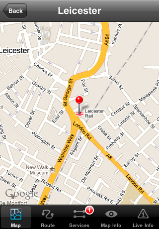
The map is hand drawn by Visual IT and provides a unique geographically based view of the Great Britain rail system. You can also use your inbuilt GPS to accurately locate and track yourself and see the nearest transportation stop and distance to it. This is the only rail transportation route planner with this ability. Tap on the map for location information, use the inbuilt search feature or choose from a list of locations.
MINUTE MAP
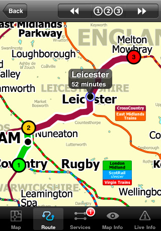
Another unique feature is the “Minute Map” option which allows you to see the travel times from a start point to all other locations on the map. This is a great way to view the topology of the country and gauge traveling times.
ROUTING
The application does not require an internet connection for routing and will always be available to display a clear and detailed view of the various rail operating company systems, plus list and animate the optimum route for your journey. This product provides the fastest route calculations of any mobile routing application using actual published journey times with the ability to select the quickest route or the route with the least changes.
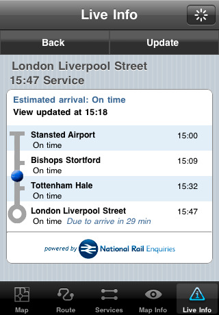
LIVE INFO
When an internet connection is available the user can check train arrivals and departures with live data supplied by National Rail Enquiries. Also shown is the estimated current real time position of the train for any of the listed services.
· The only rail app with a rail map.
· Full offline map and routing, works anywhere, no internet connection required.
· Designed for the first time visitor and experienced commuter.
· Simple, fast and intuitive to use.
· Colourful clear custom drawn geographically accurate mapping.
· Animates the route and allows tracking of the journey using GPS.
· Instantly see the route of any transport service drawn on the map.
· Save and recall favourite and recent journeys.
· One touch take me home feature.
· Unique "Minute Map" feature allows quick view of all journey times from a start location.
· Services can be turned on or off, routing round problems.
· Works on any iPhone or iPod with iOS 3.0 or above.
· GPS location and tracking.
· View station locations on a Google map (internet required).
· View Live train departures and arrivals (internet required, live data supplied by National Rail Enquiries).
Like it? Share with your friends!
If you got an error while installing Themes, Software or Games, please, read FAQ.
Supported operating systems:
Apple iOS 10.x (iPad), Apple iOS 10.x (iPhone), Apple iOS 11.x (iPad), Apple iOS 12.x (iPad), Apple iOS 12.x (iPhone), Apple iOS 4.0.x (iPhone), Apple iOS 4.0.x (iPod Touch), Apple iOS 4.2.x (iPad), Apple iOS 4.2.x (iPhone), Apple iOS 4.2.x (iPod Touch), Apple iOS 4.3.x (iPad), Apple iOS 4.3.x (iPhone), Apple iOS 4.3.x (iPod Touch), Apple iOS 5.0 (iPad), Apple iOS 5.0 (iPhone), Apple iOS 5.0 (iPod Touch), Apple iOS 6.0 (iPad), Apple iOS 6.0 (iPhone), Apple iOS 6.0 (iPod Touch), Apple iOS 7.0 (iPad), Apple iOS 7.0 (iPhone), Apple iOS 7.0 (iPod Touch), Apple iOS 8.x (iPad), Apple iOS 8.x (iPhone), Apple iOS 8.x (iPod Touch), Apple iOS 9.x (iPad), Apple iOS 9.x (iPhone), Apple iOS 9.x (iPod Touch), Apple iPhone OS 3.1.x, Apple iPhone OS 3.1.x (iPod Touch), Apple iPhone OS 3.2.x (iPad)
Similar Software:
Tuscany for Foodies Tuscany for Foodies - Tuscany for Foodies introduces you to the best of foodie Tuscany, from the butchers, bakers, and cheese makers who adhere to ancient traditions and proudly sell their goods in small shops, to restaurants large and small that process local ingredients into good-to-eat meals
Denver Daytrips Denver Daytrips - Visiting Denver and have a few hours, a day or more, and want to see the city, easily visit nearby towns and do some high-country exploring? Download this Denver Daytrips app, stick your iPhone in your pocket and head out. Or, grab your iPad and get going
Catania World Travel Catania World Travel - Map with locate me function makes you free to move.
Background reading always accompanies you on your trip
Bangkok Maps Bangkok Maps - software that helps you download and store the travel maps and plans you need. This super-handy app lets you download publicly available maps and store them on your iPhone or iPod Touch. You can download the maps when you have fast wifi connection - and then use any time in the future without delay
Vermont Winter Fun Vermont Winter Fun - When the temperature takes a dive, crack into this application for a feast of activities, from mild to wild, to keep you entertained and out savoring the natural beauty of the Green Mountain State, in ways you might not have thought of until now
Denver Maps Denver Maps - software that helps you download and store the travel maps and plans you need. This super-handy app lets you download publicly available maps and store them on your iPhone or iPod Touch. You can download the maps when you have fast wifi connection - and then use any time in the future without delay
London Central Bus 10 London Central Bus 10 - The new Zuti London Bus map has finally arrived, making it easy to travel by bus anywhere in central London. This clear and colourful map covers a detailed street level area of 6 miles by 4 miles and includes over 1300 bus stops and 189 bus routes
TransitM&S Phoenix TransitM&S Phoenix - TransitM&S is an easy-to-use transit application that provides bus info for Valley Metro Transit at greater Phoenix metro area.
The app is designed for offline use. It is ideal for iPod Touch users. Even for iPhone users, it is designed to save money because AT&T no longer offers the unlimited data plan
TransitGuru Portland TriMet The only transit app that offers offline schedules, system maps, multiple transportation types (train or bus) or agencies for single metro areas, alarms to wake you up when arrival, and integration with Yelp and Google Map
New York Subway by Zuti New York Subway by Zuti - The "New York Subway" application is a superb geographically based map and route planner for the New York public transport systems
Other Software by developer «Visual IT»:
Tube 2 Miami (UIQ3) Tube 2 Miami (UIQ3) - This map package for Tube 2 consists of a fully scrollable detailed map of the Miami metro & rail system.
Plan journeys on this system, list details of the quickest routes and see a superb animated display of your journey tracking around the system map
Tube 2 Boston Pro (UIQ) Tube 2 Boston Pro (UIQ) - This map package for Tube 2 consists of a fully scrollable detailed map of the Boston metro & commuter rail system and linked street maps of central Boston.
Plan journeys on the metro system, list details of the quickest routes and see a superb animated display of your journey tracking around the system map
Tube 2 Madrid (Palm OS) Tube 2 Madrid (Palm OS) - This map package for Tube 2 consists of a fully scrollable detailed map of the Madrid metro system.
Plan journeys on this system, list details of the quickest routes and see a superb animated display of your journey tracking around the system map
Tube 2 London Geo (UIQ) Tube 2 London Geo (UIQ) - This superb map package for Tube 2 is the ideal map for anyone who needs to get around London using the underground system and would like to know just exactly where they are.
The map geographically accurately locates the central London stations, overlaid onto a street map. Now you can easily see how these stations fit into the real world
Tube 2 Paris (Palm OS) Tube 2 Paris (Palm OS) - This map package for Tube 2 consists of a fully scrollable detailed map of the Paris metro and RER system.
Plan journeys on this system, list details of the quickest routes and see a superb animated display of your journey tracking around the system map.
A Pro version is also available with integrated high quality street maps of central Paris
Simple View Simple View - This viewer will get the best out of your palm device whether its a state of the art Hi-Res device or a simple grey scale Palm.
Its most unique & impressive feature is that you can load and view large images of virtually any size on your Palm and smoothly scroll around them zooming in/out at will. No other image viewer gives you this functionality
Tube 2 Washington (UIQ) Tube 2 Washington (UIQ) - This map package for Tube 2 consists of a fully scrollable detailed map of the Washington metro system.
Plan journeys on this system, list details of the quickest routes and see a superb animated display of your journey tracking around the system map
London Central Bus 10 London Central Bus 10 - The new Zuti London Bus map has finally arrived, making it easy to travel by bus anywhere in central London. This clear and colourful map covers a detailed street level area of 6 miles by 4 miles and includes over 1300 bus stops and 189 bus routes
Tube 2 Seoul (UIQ3) Tube 2 Seoul (UIQ3) - This map package for Tube 2 consists of a fully scrollable detailed map of the Seoul Metropolitan Subway system.
Plan journeys on this system, list details of the quickest routes and see a superb animated display of your journey tracking around the system map
Tube 2 Dublin Pro (Palm OS) Tube 2 Dublin Pro (Palm OS) - This map package for Tube 2 consists of a fully scrollable detailed map of the Dublin rail system and linked street maps of central Dublin.
Plan journeys on the rail system, list details of the quickest routes and see a superb animated display of your journey tracking around the system map


")
")
")
")
")

")
")
")