Platforms: iPhone, iPad, iPod Touch, Apple iPhone OS
Categories: Travel & Navigation
Upload date: 10 Nov 12
Developer: Visual IT
License: Commercial
Price: 2.99 $
Downloads: 33
Paris Metro by Zuti - This Zuti application contains a visually unique map of the Paris transport system and a superb animated journey planner to help you get around the Metro, RER, SNCF, Tram, Tvm, and Vogueo services. Now revised and updated to include a larger geographic area which covers more of the outlying areas surrounding Paris. Also newly added are SNCF train services as well as the bus services RER C, RER P, Paris par le Train Navette and Tvm.
MAP
Unlike old fashioned schematic style maps this product contains a geographically accurate central area showing major streets, parks, places of interest, etc, allowing the user to easily get their bearings in the city. You can also use your inbuilt GPS to accurately locate and track yourself within the city centre and see the nearest transportation stop and distance to it. This is the only pubic transportation route planner with this ability. Tap on the map for location information, use the inbuilt search feature or choose from a list of locations. Places of interest, museums, hotels, parks, restaurant, shops, hospitals, streets, etc, are also included. The route planner will automatically suggest the nearest station to any place of interest you select. No internet connection is required for any of this functionality.
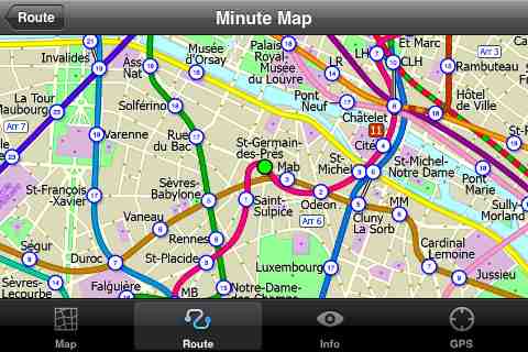
MINUTE MAP
Another great feature is the “Minute Map” option which allows you to see the travel times from a start point to all other locations on the map. This is a unique way to view the topology of a city and gauge traveling times.
ROUTING
The application does not require an internet connection and will always be available to display a clear and detailed view of the city transport systems, plus list and animate the optimum route for your journey. This product provides the fastest route calculations of any mobile routing application (virtually instantaneous) using actual published journey times with the ability to select the quickest route or the route with the least changes.
What's New in This Release:
· Completely new map and routing.
· Deep integration with inbuilt online mapping.
· Lots of new features.
· Bug fixes.
What's New in 1.3:
· Support for retina display
· New "Measure Tool"
· Bug fix for iOS 5
What's New in 1.2:
· Updated map and routes.
· Faster map loading.
· New route description text and layout.
· New "Take me home" option.
· New "Recent routes" option.
· Improved Live Info, now with departure boards.
· Various other minor updates and improvements.
Like it? Share with your friends!
If you got an error while installing Themes, Software or Games, please, read FAQ.
Supported operating systems:
Apple iOS 10.x (iPad), Apple iOS 10.x (iPhone), Apple iOS 11.x (iPad), Apple iOS 12.x (iPad), Apple iOS 12.x (iPhone), Apple iOS 4.0.x (iPhone), Apple iOS 4.0.x (iPod Touch), Apple iOS 4.2.x (iPad), Apple iOS 4.2.x (iPhone), Apple iOS 4.2.x (iPod Touch), Apple iOS 4.3.x (iPad), Apple iOS 4.3.x (iPhone), Apple iOS 4.3.x (iPod Touch), Apple iOS 5.0 (iPad), Apple iOS 5.0 (iPhone), Apple iOS 5.0 (iPod Touch), Apple iOS 6.0 (iPad), Apple iOS 6.0 (iPhone), Apple iOS 6.0 (iPod Touch), Apple iOS 7.0 (iPad), Apple iOS 7.0 (iPhone), Apple iOS 7.0 (iPod Touch), Apple iOS 8.x (iPad), Apple iOS 8.x (iPhone), Apple iOS 8.x (iPod Touch), Apple iOS 9.x (iPad), Apple iOS 9.x (iPhone), Apple iOS 9.x (iPod Touch), Apple iPhone OS 3.1.x, Apple iPhone OS 3.1.x (iPod Touch), Apple iPhone OS 3.2.x (iPad)
Similar Software:
Canberra Bus Canberra Bus is a friendly timetable application that provides bus timetable for Canberra bus transport commuters. If you need an application to keep track of your favorite bus timetables throughout Canberra then this is for you!
· Access to all timetables in Canberra, Australia.
· Save and remove favorite routes at the touch of a button
Bremerhaven World Travel Bremerhaven World Travel - map with locate me function makes you free to move.
Background reading always accompanies you on your trip
Best Western to Go With ‘Best Western to Go’ you can find locations and make reservations for any Best Western hotel worldwide, track details of your trip and share your trip details with friends and family.
Starting out, ’Best Western to Go’ will load your current location and highlight nearby Best Western hotels
Los Angeles Maps Los Angeles Maps - software that helps you download and store the travel maps and plans you need. This super-handy app lets you download publicly available maps and store them on your iPhone or iPod Touch. You can download the maps when you have fast wifi connection - and then use any time in the future without delay
Cleveland(Ohio) World Travel Cleveland(Ohio) World Travel - Map with locate me function makes you free to move.
Background reading always accompanies you on your trip
Virginia Wine In My Pocket Virginia Wine In My Pocket - According to the Travel Channel, "Virginia is carving its own niche in the little black books of savvy wine lovers searching for the next big thing."
Virginia Wine in My Pocket is a guide for travelers in Virginia wine country
Hotel Finder Hotel Finder is an easy-to use, quick, and convenient way to find a hotel near you. This is a free application, so be sure to check it out!
Hotel Mate quickly identifies your location and lets you choose the nearest hotel
Weekend Trips Near San Antonio Weekend Trips Near San Antonio - GPSmyCity.com's day trips application is a powerful tool for planning your weekend getaways. With a well researched list of weekend getaway spots around the city you live in and the powerful navigation features built-in, you will never be bored on a weekend.
This app works on iPhone, iPad and iPod Touch
Short Trips Around Houston Short Trips Around Houston - GPSmyCity.com's day trips and weekend getaways appliaction is a powerful tool for planning a weekend away from the city. With a well researched list of getaway spots around the city you live in, you can explore natural wonders, regional history, and small town charm within a short drive from your home
Other Software by developer «Visual IT»:
Barcelona Metro by Zuti Barcelona Metro by Zuti - The Barcelona Metro application is a superb geographically based map and route planner for the Barcelona TMB (Transports Metropolitan de Barcelona) Metro and Tram services. This application is one in a worldwide series of Zuti maps from Visual IT who have been producing public transportation maps for mobile devices for many years
Washington Metro for iPad by Zuti Washington Metro for iPad by Zuti - The new Washington Metro 10 map makes it easy to travel in and around the city using the WMATA Metro, MARC and VME systems. Also included are the Potomac river taxi routes and the DC Circulator bus routes
Tube 2 San Francisco (UIQ) Tube 2 San Francisco (UIQ) - This map package for Tube 2 consists of a fully scrollable detailed map of the San Francisco metro & rail systems.
The maps in this package cover the BART, SCVTA & Caltrain systems plus the Municipal Metro, Municipal Historic Street Car and Cable Car systems in central SF
Rough Guides Map Dublin Rough Guides Map Dublin... These guides are a series of fantastic interactive maps.
Produced in conjunction with the premier travel publisher Rough Guides.
Discover and explore Dublin using full colour interactive linked maps, in this simple to use PDA version of The Rough Guides Dublin
Chicago Metro by Zuti Chicago Metro by Zuti - Chicago Metro map makes it easy to travel in and around the city using the CTA rapid transport system, the commuter services of Metrarail, Northern Indiana Commuter Transportation District and also the Water Taxi services
New York Subway by Zuti New York Subway by Zuti - The "New York Subway" application is a superb geographically based map and route planner for the New York public transport systems
Tube 2 New York Geo (Palm OS) Tube 2 New York Geo (Palm OS) - This superb map package for Tube 2 is the ideal map for anyone who needs to get around New York City using the MTA subway system and would like to know just exactly where they are.
The map geographically accurately locates all of Manhattans central stations, overlaid onto a street map
Rome Metro for iPad by Zuti Rome Metro for iPad by Zuti - The Zuti Rome Metro application is a superb geographically based map and route planner for the Metro, Tram, Urban and Regional rail systems. Unlike old fashioned schematic style maps this product contains a geographically accurate central area showing major streets, parks and places of interest etc, allowing the user to easily get their bearings
Tube Washington (Series 60) Tube Washington (Series 60) - Our highly acclaimed Tube application that guides you around the Washington D.C. metro system is now available for your Series 60 Symbian powered phone. An essential addition to your phone for locals and tourists alike.
· A detailed clear colour map of the transport system fully scrollable.
· Quick find station utility
Tube 2 Berlin (UIQ) Tube 2 Berlin (UIQ) - This map package for Tube 2 consists of a fully scrollable detailed map of the Berlin Metro (U-Bahn/S-Bahn).
Plan journeys on this system, list details of the quickest routes and see a superb animated display of your journey tracking around the system map.
Berlin is the capital and largest city in Germany


 World Travel")


")


")

")
")