Platforms: iPhone, iPad, iPod Touch, Apple iPhone OS
Categories: Travel & Navigation
Upload date: 11 Apr 12
Developer: Visual IT
License: Commercial
Price: 2.99 $
Downloads: 32
London Bus by Zuti - The new Zuti London Bus map has finally arrived, making it easy to travel by bus anywhere in central London. This clear and colourful map covers a detailed street level area of 6 miles by 4 miles and includes over 1300 bus stops and 189 bus routes.
All day and night bus routes running through the central area are covered in full and this means routes run to Wembley, Edgware, Edmonton, Ilford, Woolwich, Croydon and Richmond in the day and to Uxbridge, Harrow Weald, Stanmore, Kingston, Edgware, Barnet, Heathrow Airport, Enfield, Waltham Cross, Hainault, Romford, Erith (Bexleyheath), Foots Cray, St. Paul's Cray, New Addington, Old Coulsdon, and Sutton at night.
The map and routing information is stored completely on the device and needs no internet connection, making it ideal for iPod Touch and iPhone users visiting the UK who want to avoid paying roaming charges.
MAP
The map is hand drawn by Visual IT and provides a unique geographically based view of the city with many places of interest drawn directly on the background so you can easily get your bearings when traveling in and around the city. You can also use your inbuilt GPS (can also work with iPod Touch devices) to accurately locate and track yourself within the city centre and see the nearest transportation stop and distance to it. This is the only pubic transportation route planner with this ability.
Tap on the map for location information, use the inbuilt search feature or choose from a list of locations. Places of interest, museums, hotels, parks, restaurant, shops, hospitals, streets, etc, are also included. The route planner will automatically suggest the nearest station to any place of interest you select.
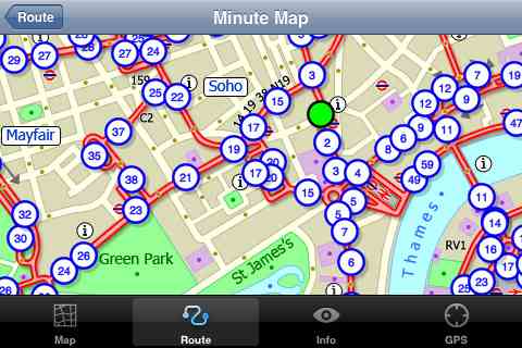
MINUTE MAP
Another unique feature of this product is our “Minute Map” option which allows you to see the travel times from a start point to all other locations on the map. This can be very useful and is not available in any other product on the market.
NO INTERNET CONNECTION REQUIRED
The map and routing does not require an internet connection and you will not be charged data connection fees. This also means the application runs successfully underground and on an iPod Touch. The only feature that requires an internet data connection is the “Live Info” which is optional and if used only requires a small amount of data.
ROUTING
Does not require an internet connection and will always be available to display a clear and detailed view of the city bus transport system, plus list and animate the optimum route for your journey. Provides the fastest route calculations of any mobile routing application (virtually instantaneous) using actual published journey times with the ability to select the quickest route or the route with the least changes.
What's New in This Release:
· Much larger and more detailed map.
· Map now includes London 2012 Olympic venues.
· Lots of minor improvements.
Like it? Share with your friends!
If you got an error while installing Themes, Software or Games, please, read FAQ.
Supported operating systems:
Apple iOS 10.x (iPad), Apple iOS 10.x (iPhone), Apple iOS 11.x (iPad), Apple iOS 12.x (iPad), Apple iOS 12.x (iPhone), Apple iOS 4.0.x (iPhone), Apple iOS 4.0.x (iPod Touch), Apple iOS 4.2.x (iPad), Apple iOS 4.2.x (iPhone), Apple iOS 4.2.x (iPod Touch), Apple iOS 4.3.x (iPad), Apple iOS 4.3.x (iPhone), Apple iOS 4.3.x (iPod Touch), Apple iOS 5.0 (iPad), Apple iOS 5.0 (iPhone), Apple iOS 5.0 (iPod Touch), Apple iOS 6.0 (iPad), Apple iOS 6.0 (iPhone), Apple iOS 6.0 (iPod Touch), Apple iOS 7.0 (iPad), Apple iOS 7.0 (iPhone), Apple iOS 7.0 (iPod Touch), Apple iOS 8.x (iPad), Apple iOS 8.x (iPhone), Apple iOS 8.x (iPod Touch), Apple iOS 9.x (iPad), Apple iOS 9.x (iPhone), Apple iOS 9.x (iPod Touch), Apple iPhone OS 3.1.x, Apple iPhone OS 3.1.x (iPod Touch), Apple iPhone OS 3.2.x (iPad)
Similar Software:
StayHIP StayHIP is the best way to find and book boutique hotels. StayHIP brings you only the most chic and unique hotels in the world all with lush pictures, lists of amenities and the ability to search for your hotel by keywords. And you can book your room right in the application
Barcelona Metro by Zuti Barcelona Metro by Zuti - The Barcelona Metro application is a superb geographically based map and route planner for the Barcelona TMB (Transports Metropolitan de Barcelona) Metro and Tram services. This application is one in a worldwide series of Zuti maps from Visual IT who have been producing public transportation maps for mobile devices for many years
Washington Metro by Zuti Washington Metro by Zuti - The new Washington Metro 10 map makes it easy to travel in and around the city using the WMATA Metro, MARC and VME systems. Also included are the Potomac river taxi routes and the DC Circulator bus routes
London Tube for iPad by Zuti London Tube for iPad by Zuti - "London Tube 10" is a superb geographically based map and route planner for the London Underground, Overground, Docklands Light Railway (DLR), Croydon Tramlink and London Airport Express services
San Francisco Metro 10 for iPad San Francisco Metro 10 for iPad - The new San Francisco Metro 10 application makes it easy to travel in and around the city using the Metro (BART), Streetcar, Light Rail(MUNI), Ferry and Presidio shuttle bus services
Hong Kong Maps Hong Kong Maps - software that helps you download and store the travel maps and plans you need. This super-handy app lets you download publicly available maps and store them on your iPhone or iPod Touch. You can download the maps when you have fast wifi connection - and then use any time in the future without delay
Berlin Metro by Zuti Berlin Metro by Zuti - The new Berlin Metro map makes it easy to travel in and around the city using the Metro (U-Bahn) Suburban Rail (S-Bahn) and Tram (MetroTram and Straßenbahn) systems
thetrainline thetrainline is the UK's leading independent train ticket retailer. We sell tickets for all train companies to all national destinations.
This is the official application from thetrainline and is perfect for anyone who wants to view UK train times or buy tickets on the move
New York Subway 10 for iPad New York Subway 10 - The “New York Subway” application is a superb geographically based map and route planner for the New York public transport systems
Tyne & Wear Metro by Zuti for iPad Tyne & Wear Metro by Zuti for iPad - The new Tyne & Wear Metro map makes it easy to travel in and around the city using the Nexus Metro system. Unlike old fashioned schematic style maps this product contains a geographically accurate central area showing major streets, parks and places of interest etc, allowing the user to easily get their bearings
Other Software by developer «Visual IT»:
Tube 2 Brussels (UIQ) Tube 2 Brussels (UIQ) - This map package for Tube 2 consists of a fully scrollable detailed map of the Brussels tram, metro & bus system.
Plan journeys on these systems, list details of the quickest routes and see a superb animated display of your journey tracking around the system map
TUBE 2 New York City (Blackberry) TUBE 2 New York City (Blackberry)
Tube 2 New York City
Transform your Blackberry into a fully scrollable detailed map of the New York City MTA subway system.
Plan journeys on the New York City subway system, have the quickest routes to hand, with all the details you need including line changes, platform directions and accurate journey times
Tube 2 Munich (UIQ3) Tube 2 Munich (UIQ3) - This map package for Tube 2 consists of a fully scrollable detailed map of the Munich metro, rail & tram system.
Plan journeys on this system, list details of the quickest routes and see a superb animated display of your journey tracking around the system map.
Munich is the capital city of Bavaria, the southern most German federal state
Tube 2 Chicago (UIQ) Tube 2 Chicago (UIQ) - This map package for Tube 2 consists of a fully scrollable detailed map of the Chicago metro & commuter rail system.
It includes the rapid transport system of subway and elevated lines, in addition to the many commuter rail lines. The map also indicates how the Amtrak intercity routes intersect with the cities transport network
Tube 2 Engine (UIQ3) Tube 2 Engine (UIQ3) - Transform your PDA into a fully scrollable detailed map of one of the worlds subway or metro systems.
See your journeys come alive with a superb animated display.
Save hours by automatically having the quickest routes to hand, with all the details you need including line changes, platform directions and accurate journey times
London Underground for iPad by Zuti London Underground for iPad by Zuti - "London Underground 10" is a superb map and route planner for the London Underground, Overground and Docklands Light Railway (DLR) services. So you can make a quick exit when you leave the train we have now added exit information for all stations on the London Underground
Tube 2 Melbourne (Palm OS) Tube 2 Melbourne (Palm OS) - This map package for Tube 2 consists of a fully scrollable detailed map of the Melbourne metro & rail system.
Plan journeys on this system, list details of the quickest routes and see a superb animated display of your journey tracking around the system map
Edinburgh Mini A-Z Edinburgh Mini A-Z - This street map of Edinburgh covers an area extending to Cramond, Granton, Leith, Portobello, Musselburgh, Whitecraig, Dalkeith, Bonnyrigg (part), Loanhead, Fairmilehead, Juniper Green, Currie, Balerno, and Edinburgh Airport.
Major buildings are colour-coded to indicate places of interest and other buildings that are open to the public
Barcelona Metro 10 for iPad Barcelona Metro 10 - This Zuti application contains a visually unique map of the Barcelona transport system and a superb animated journey planner to help you get around the TMB (Transports Metropolitan de Barcelona), FGC (Ferrocarrils de la Generalitat de Catalunya) Metro and Tram services
Tube 2 Madrid (UIQ) Tube 2 Madrid (UIQ) - This map package for Tube 2 consists of a fully scrollable detailed map of the Madrid metro system.
Plan journeys on this system, list details of the quickest routes and see a superb animated display of your journey tracking around the system map


")
")
")
")
")

")


")