Washington Metro for iPad by Zuti - The new Washington Metro 10 map makes it easy to travel in and around the city using the WMATA Metro, MARC and VME systems. Also included are the Potomac river taxi routes and the DC Circulator bus routes. Unlike old fashioned schematic style maps this product contains a geographically accurate central area showing major streets, parks and places of interest etc, allowing the user to easily get their bearings.
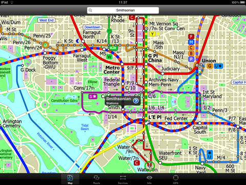
MAP
The map is hand drawn by Visual IT and provides a unique geographically based view of Washington DC with many places of interest drawn directly on the background so you can easily get your bearings when traveling around the city. You can also use your inbuilt GPS to accurately locate and track yourself within the city centre and see the nearest transportation stop and distance to it. This is the only pubic transportation route planner with this ability.
Tap on the map for location information, use the inbuilt search feature or choose from a list of locations. Places of interest, museums, hotels, parks, restaurant, shops, hospitals, streets, etc, are also included. The route planner will automatically suggest the nearest station to any place of interest you select.
MINUTE MAP
Another great feature is the “Minute Map” option which allows you to see the travel times from a start point to all other locations on the map. This is a unique way to view the topology of a city and gauge traveling times.
ROUTING
The application does not require an internet connection and will always be available to display a clear and detailed view of the city transport systems, plus list and animate the optimum route for your journey. This product provides the fastest route calculations of any mobile routing application (virtually instantaneous) using actual published journey times with the ability to select the quickest route or the route with the least changes.
LIVE INFO
When an internet connection is available, optional "Live Information" on the current state of the transport services can be viewed (and automatically saved for future reference) allowing you to plan your journeys in advance and avoid any potential delays. Unique to this application is the ability to turn off services that are out of action and automatically calculate an alternative route.
· Full offline map and routing, no internet connection required.
· Colourful clear custom drawn geographically accurate mapping.
· Unique "Minute Map" feature allows quick view of all journey times from a start location.
· Services can be viewed on the map and turned on/off, routing around problems.
· GPS location and tracking.
· Streets, Places of interest etc built into the application.
· Favourite routes can be stored and recalled.
· Access to live service information.
What's New in This Release:
· Updated map and routes.
· Faster map loading.
· New route description text and layout.
· New "Take me home" option.
· New "Recent routes" option.
· Improved Live Info, now with departure boards.
· Various other minor updates and improvements.
Like it? Share with your friends!
If you got an error while installing Themes, Software or Games, please, read FAQ.
Supported operating systems:
Apple iOS 10.x (iPad), Apple iOS 11.x (iPad), Apple iOS 12.x (iPad), Apple iOS 4.2.x (iPad), Apple iOS 4.3.x (iPad), Apple iOS 5.0 (iPad), Apple iOS 6.0 (iPad), Apple iOS 7.0 (iPad), Apple iOS 8.x (iPad), Apple iOS 9.x (iPad), Apple iPhone OS 3.2.x (iPad)
Similar Software:
Augsburg (Germany) Map Offline Augsburg (Germany) Map Offline - This will be perfect when you are traveling and you don't have internet connection. This Offline Maps is not a replacement of Google Maps. It is used when you don't have internet connection and want to use maps
The World by National Geographic The World by National Geographic - Exclusively designed to leverage features and functionality for the iPad, The World by National Geographic provides one-touch access to locations worldwide
Ljubljana Walking Tours and Map This application presents you several self-guided walking tours to see the best of the city, and it comes with detailed tour route maps and powerful navigation features to guide you from one sight to the next
Italy Travel Guide - Lonely Planet Italy Travel Guide - Lonely Planet - The ultimate guide to exploring Italy – from the rolling hills of Tuscany to the back streets of Rome. Get the insider knowledge and recommendations of 10 expert Lonely Planet authors, combined with detailed maps and GPS - all of which work with no internet connection or data roaming fees
Johannesburg Street Map Johannesburg Street Map - Lets you find all streets, and many useful locations such as ATM's, parkings, museums, and many others. Remembers where you've been so you can find that parking spot where you left your rental car
Bangkok Map Offline Bangkok Map Offline - This will be perfect when you are traveling and you don't have internet connection. This Offline Maps is not a replacement of Google Maps. It is used when you don't have internet connection and want to use maps
Brecon Beacons National Park - GPS Map Navigator Brecon Beacons National Park - GPS Map Navigator - FlytoMap provides complete, quick and easy to use map applications for navigation for iPhone. Continues in the tradition of offering depth of information and functionality across expected places all over the world, exploring the map you get maximum details obtaining detailed information of every object on the map
San Francisco (Bay Area) Map Offline San Francisco (Bay Area) Map Offline - This will be perfect when you are traveling and you don't have internet connection. This Offline Maps is not a replacement of Google Maps. It is used when you don't have internet connection and want to use maps
Other Software by developer «Visual IT»:
Tube Seoul (Series 60) Tube Seoul (Series 60) - Our highly acclaimed Tube application that guides you around the complex subway system of Seoul is now available for your Series 60 Symbian powered phone. An essential addition to your phone for locals and tourists alike.
· A detailed clear colour map of the Seoul subway system fully scrollable.
· Quick find station utility
Vienna Metro 10 Vienna Metro 10 - This Zuti application contains a visually unique map of Vienna's transport systems and a superb animated journey planner to help you get around the Metro (U-Bahn), Suburban Rail (S-Bahn) and Tram (Stragenbahn)
Tyne & Wear Metro by Zuti Tyne & Wear Metro by Zuti - The new Tyne & Wear Metro map makes it easy to travel in and around the city using the Nexus Metro system. Unlike old fashioned schematic style maps this product contains a geographically accurate central area showing major streets, parks and places of interest etc, allowing the user to easily get their bearings
Simple View Simple View - This viewer will get the best out of your palm device whether its a state of the art Hi-Res device or a simple grey scale Palm.
Its most unique & impressive feature is that you can load and view large images of virtually any size on your Palm and smoothly scroll around them zooming in/out at will. No other image viewer gives you this functionality
Rough Guides Map Dublin Rough Guides Map Dublin... These guides are a series of fantastic interactive maps.
Produced in conjunction with the premier travel publisher Rough Guides.
Discover and explore Dublin using full colour interactive linked maps, in this simple to use PDA version of The Rough Guides Dublin
Paris Metro by Zuti Paris Metro by Zuti - This Zuti application contains a visually unique map of the Paris transport system and a superb animated journey planner to help you get around the Metro, RER, SNCF, Tram, Tvm, and Vogueo services. Now revised and updated to include a larger geographic area which covers more of the outlying areas surrounding Paris
TUBE 2 Rome (Palm OS) TUBE 2 Rome (Palm OS) - This map package for Tube 2 consists of a fully scrollable detailed map of the Rome metro & rail system.
Plan journeys on this system, list details of the quickest routes and see a superb animated display of your journey tracking around the system map.
A Pro version is also available with integrated high quality street maps of central Rome
London Visitors A-Z for iPad London Visitors A-Z for iPad - The London Visitors A-Z map of central London is designed especially for the tourist
Tube 2 Barcelona Pro (UIQ) Tube 2 Barcelona Pro (UIQ) - This map package for Tube 2 consists of a fully scrollable detailed map of the Barcelona metro & rail system and linked street maps of central Barcelona.
Plan journeys on the metro system, list details of the quickest routes and see a superb animated display of your journey tracking around the system map
Tube Philadelphia (Palm OS) Tube Philadelphia (Palm OS) - An award winning and highly acclaimed Palm OS application that guides you around the complex rail system of Philadelphia. An essential addition to your Palm device for locals and tourists alike.
Tube's features include:
A detailed clear colour (or grey scale) map of the transport system fully scrollable.
Quick find station utility


 Map Offline")


 Map Offline")
")


")

")
")