Barcelona Metro for iPad by Zuti - This Zuti application contains a visually unique map of the Barcelona transport system and a superb animated journey planner to help you get around the TMB (Transports Metropolitan de Barcelona), FGC (Ferrocarrils de la Generalitat de Catalunya) Metro and Tram services. Also included are airport transfer and leisure transportation such as the cable cars and Tramvia Blau bus service. Now revised and updated to include the new TMB L10 line and L9 extension.
MAP
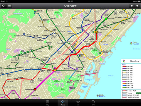
Unlike old fashioned schematic style maps this product contains a geographically accurate central area showing major streets, parks, places of interest, etc, allowing the user to easily get their bearings in the city. You can also use your inbuilt GPS to accurately locate and track yourself within the city centre and see the nearest transportation stop and distance to it. This is the only pubic transportation route planner with this ability. Tap on the map for location information, use the inbuilt search feature or choose from a list of locations. Places of interest, museums, hotels, parks, restaurant, shops, hospitals, streets, etc, are also included. The route planner will automatically suggest the nearest station to any place of interest you select. No internet connection is required for any of this functionality.
MINUTE MAP
Another great feature is the “Minute Map” option which allows you to see the travel times from a start point to all other locations on the map. This is a unique way to view the topology of a city and gauge traveling times.
ROUTING
The application does not require an internet connection and will always be available to display a clear and detailed view of the city transport systems, plus list and animate the optimum route for your journey. This product provides the fastest route calculations of any mobile routing application (virtually instantaneous) using actual published journey times with the ability to select the quickest route or the route with the least changes.
What's New in This Release:
· New "Measure Tool"
· Bug fix for iOS 5
What's New in 1.3:
· Updated map and routes.
· Faster map loading.
· New route description text and layout.
· New "Take me home" option.
· New "Recent routes" option.
· Improved Live Info, now with departure boards.
· Various other minor updates and improvements.
Like it? Share with your friends!
If you got an error while installing Themes, Software or Games, please, read FAQ.
Supported operating systems:
Apple iOS 10.x (iPad), Apple iOS 11.x (iPad), Apple iOS 12.x (iPad), Apple iOS 4.2.x (iPad), Apple iOS 4.3.x (iPad), Apple iOS 5.0 (iPad), Apple iOS 6.0 (iPad), Apple iOS 7.0 (iPad), Apple iOS 8.x (iPad), Apple iOS 9.x (iPad), Apple iPhone OS 3.2.x (iPad)
Similar Software:
Pubs on 'n around royal mile Pubs on 'n around royal mile - GPSmyCity.com's directory guide is a powerful tool for planning your visit to a new city. Each directory guide comes with a well researched and detailed list of related attractions; such as museums, night clubs, restaurants, cafes, shops, etc. The powerful built-in navigation features provide travel directions to each venue
FlightTrack FlightTrack - The best flight tracking app out there. Track every aspect of your domestic and international flights with real-time updates and beautiful, zoomable maps. Check gate numbers, delays and cancellations
Madrid Metro by Zuti Madrid Metro by Zuti - The new Madrid Metro 10 map makes it easy to travel in and around the city using the the Metro, Renfe Rail and Metro Ligero Rail services. Unlike old fashioned schematic style maps this product contains a geographically accurate central area showing major streets, parks and places of interest etc, allowing the user to easily get their bearings
Wales Explorer Wales Explorer - Wales as part of the United Kingdom has long and deep links with the New World. Legendary for its connections with Avalon and other touchstones of British history, it is also marked indelibly with its now declined industrial history of shipping and mining
Hong Kong Maps Hong Kong Maps - software that helps you download and store the travel maps and plans you need. This super-handy app lets you download publicly available maps and store them on your iPhone or iPod Touch. You can download the maps when you have fast wifi connection - and then use any time in the future without delay
Best Photography Spots in Cambridge (Lite Version) Best Photography Spots in Cambridge - Cambridge has an evocative array of quintessentially English sights. Use this tour to visit all the must-sees' as well as some off-the-beaten-track spots. As you go collect stunning photographs that capture the essence of this beautiful city
Denver Maps Denver Maps - Software that helps you download and store the travel maps and plans you need. This super-handy app lets you download publicly available maps and store them on your iPhone or iPod Touch. You can download the maps when you have fast wifi connection - and then use any time in the future without delay
Beijing Subway for iPad by Zuti Beijing Subway for iPad by Zuti - Beijing Metro map makes it easy to travel in and around the city using the Beijing metro system and also includes the S2 rail line to the Great Wall at Badaling
San Francisco Metro 10 for iPad San Francisco Metro 10 for iPad - The new San Francisco Metro 10 application makes it easy to travel in and around the city using the Metro (BART), Streetcar, Light Rail(MUNI), Ferry and Presidio shuttle bus services
Tokyo Metro for iPad by Zuti Tokyo Metro for iPad by Zuti - Tokyo Metro map makes it easy to travel in and around the city using the Toei Subway, JR East routes (within the Tokyo Suburban area), Shinkansen routes, Streetcars, some important private lines and Tokyo Cruise lines
London Bus by Zuti London Bus by Zuti - The new Zuti London Bus map has finally arrived, making it easy to travel by bus anywhere in central London. This clear and colourful map covers a detailed street level area of 6 miles by 4 miles and includes over 1300 bus stops and 189 bus routes
TUBE 2 Paris (Blackberry) TUBE 2 Paris (Blackberry)
Tube 2 Paris
Transform your Blackberry into a fully scrollable detailed map of the Paris Metro system.
Plan journeys on the Paris Metro system, have the quickest routes to hand, with all the details you need including line changes, platform directions and accurate journey times
Tube 2 Milan (UIQ3) Tube 2 Milan (UIQ3) - This map package for Tube 2 consists of a fully scrollable detailed map of the Milan metro & rail system.
Plan journeys on this system, list details of the quickest routes and see a superb animated display of your journey tracking around the system map
London Tube for iPad by Zuti London Tube 10 is a superb geographically based map and route planner for the London Underground, Overground, Docklands Light Railway (DLR), Croydon Tramlink and London Airport Express services
Tube 2 London Touristic (UIQ3) Tube 2 London Touristic (UIQ3) - This map package for Tube 2 is the ideal map for the tourist or business traveller who needs to get around London using the Tube system and would like to know just exactly where they are. The map geographically locates all the central stations, making it much more informative than the official topological map
Tube London (Series 60) Tube London (Series 60) - Our highly acclaimed Tube application that guides you around the complex subway system of London is now available for your Series 60 Symbian powered phone. An essential addition to your phone for locals and tourists alike.
· A detailed clear colour map of the transport system fully scrollable.
· Quick find station utility
Washington Metro for iPad by Zuti The new Washington Metro 10 map makes it easy to travel in and around the city using the WMATA Metro, MARC and VME systems. Also included are the Potomac river taxi routes and the DC Circulator bus routes
Tube 2 New York City Pro (Palm OS) Tube 2 New York City Pro (Palm OS) - This map package for Tube 2 consists of a fully scrollable detailed map of the New York City MTA subway system and linked high quality street maps of Manhattan. Also included are additional reference maps of the rail systems surrounding NYC
Tube 2 London (UIQ3) Tube 2 London (UIQ3) - This map package for Tube 2 consists of a fully scrollable detailed map of the London Underground system.
Plan journeys on the London Underground system, list details of the quickest routes and see a superb animated display of your journey tracking around the system map


")


")
")

")
")

")
")