Platforms: iPhone, iPad, iPod Touch, Apple iPhone OS
Categories: Science & Education
Upload date: 22 Oct 12
Developer: VITO Technology
License: Freeware
Downloads: 163
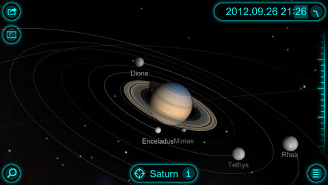
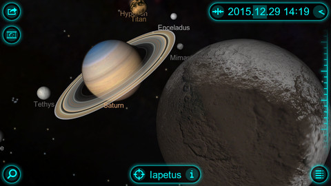
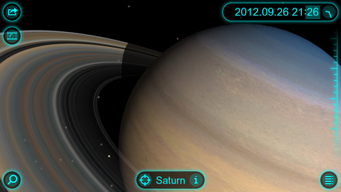
Solar Walk - Saturn - This app is a lite version of the popular astronomy software Solar Walk. It lets you explore Saturn, the sixth planet from the Sun, as well as its moons: Mimas, Enceladus, Tethys, Dione, Rhea, Titan, Hyperion, and Iapetus, in 3D.
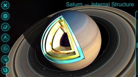
The application is packed with useful information, including size, mass, distance to the Sun, orbital velocity, internal structure, history of missions, and more. In addition, you can view beautiful images of each celestial body, as well as read the most interesting facts.
· GALAXY view - absolutely magical zoom out to view the whole galaxy option.
· TIME MACHINE - set any date you want including even minutes and take a travel through space and time.
· INFO - general info, its name, its mass, radius, distance to the sun, internal structure with the picture and science missions.
· MOONS - observe how many moons Saturn has and their track around the planet. Select one of the moons and learn.
· MIRRORING - wirelessly mirror the screen to an Apple TV 2.
· 3D MODE - to enjoy the view on 3D TV
Like it? Share with your friends!
If you got an error while installing Themes, Software or Games, please, read FAQ.
Supported operating systems:
Apple iOS 10.x (iPad), Apple iOS 10.x (iPhone), Apple iOS 11.x (iPad), Apple iOS 12.x (iPad), Apple iOS 12.x (iPhone), Apple iOS 4.3.x (iPad), Apple iOS 4.3.x (iPhone), Apple iOS 4.3.x (iPod Touch), Apple iOS 5.0 (iPad), Apple iOS 5.0 (iPhone), Apple iOS 5.0 (iPod Touch), Apple iOS 6.0 (iPad), Apple iOS 6.0 (iPhone), Apple iOS 6.0 (iPod Touch), Apple iOS 7.0 (iPad), Apple iOS 7.0 (iPhone), Apple iOS 7.0 (iPod Touch), Apple iOS 8.x (iPad), Apple iOS 8.x (iPhone), Apple iOS 8.x (iPod Touch), Apple iOS 9.x (iPad), Apple iOS 9.x (iPhone), Apple iOS 9.x (iPod Touch)
Similar Software:
Astrology Trivia Quiz Astrology Trivia Quiz features 9 different game modes, in both single and multiplayer for you to play and enjoy
Redshift Redshift - Redshift brings the night sky to your iOS device, with all major and dwarf planets, constellations and bright stars - displayed in top quality. The application goes beyond the basic planetarium because it also displays a 3D-model of the nearby part of our Galaxy.
Perform various amazing 3-D flights and visit the Moon and all planets in our Solar system
SkySafari 3 SkySafari 3 - SkySafari is a chart star app for all astronomy enthusiasts. It includes a comprehensive database of 120,000 stars and 220 of the most known star clusters, nebulae and galaxies.
In addition, the application displays the Solar System's planets along with their moons, as well as the most important asteroids and comets
HubbleSite HubbleSite, the online home of NASA’s Hubble Space Telescope, invites you to help choose the world’s most popular Hubble images. Get wallpapers, Hubble facts, and more.
Hubble’s vast collection of images awaits your critical and discerning eye
LunaSolCal for iPhone/iPad LunaSolCal for iPhone/iPad calculates times of sunrise, sunset, moonrise and moonset for your location at any given date
Sky Above Sky Above - Sky Above is an iOS app which tells you where stars, constellations, planets and satellites are above you in the sky. The application also uses augmented reality to show the real sky using the device's camera. Just hold your iPhone or iPad up to the sky and the names of the sky objects will be overlayed on the camera display
Astronaut Envi Astronaut Envi - Astronaut Envi brings thousands of Web-based space photos to your iPhone or iPod touch. If you've always wanted to be a space traveler, or just like looking at the amazing images our astronauts have returned, Astronaut Envi is for you
The Night Sky for iPhone/iPad The Night Sky for iPhone/iPad - The Night Sky is a useful app that allows astronomy enthusiasts to quickly identify celestial bodies.
Simply point your iPhone, iPad or iPod touch to a star, constellation, planet or other object in the sky and the software will tell you its name
iMoon iMoon calculates the current moon phase and pictures it approximatively. Additional moon data (moon age, distance, constellation, visibility in percent, etc.) is displayed in real-time.
Via Fast Forward/Rewind (with adjustable time shift) you can view past and future moon phases.
What's New in This Release:
· Updated for iPad
Cassini Cassini - NASA’s Cassini mission launched in 1997 and has been exploring the Saturnian system from orbit since July 2004. Currently in its second extended mission, Cassini continues to unravel mysteries about Saturn and its atmosphere, rings and magnetosphere, and its moons, particularly Titan and the icy satellites
Other Software by developer «VITO Technology»:
Map of Pakistan Map of Pakistan - A map of Pakistan. Good for intercity travels with SmartMap.
Layers include:
Towns
Settlements
Airports
Roads
Railroads
Rivers
Inland water
Administrative borders
International borders
Trees
Map scale is 1:1 million.
Good for use with any version of SmartMap. SmartMap can be purchased here
Map of Romania Map of Romania - A map of Romania. Good for intercity travels with SmartMap.
Layers include:
Towns
Settlements
Airports
Roads
Railroads
Rivers
Inland water
Administrative borders
International borders
Trees
Map scale is 1:1 million.
Good for use with any version of SmartMap. SmartMap can be purchased here
Map of Turkey Map of Turkey - A map of Turkey, divided into 67 smaller territories for the ease of use. Good for intercity travels with SmartMap.
Layers include:
Towns
Settlements
Airports
Roads
Railroads
Rivers
Inland water
Administrative borders
International borders
Trees
Map scale is 1:1 million
VITO Weather VITO Weather - Weather is a Windows Mobile software for getting weather forecast right on your mobile device. It has intuitive and finger-friendly interface.
Weather was designed specially for Winterface - next generation Windows Mobile shell. When added to Winterface there appears a special Weather icon among other status icons with “live” info
VITO SmartMap Smartphone VITO SmartMap for Smartphone is GPS moving map for your Smartphone.
It uses relatively small vector maps, which are perfect for driving or hiking with it. You can also use VITO SmartMap without maps for recording tracks to find your way back
Map of Texas (US State) Map of Texas (US State) - A map of the Texas by VITO Technology. Good for intercity travels with SmartMap.
SmartMap is a mobile device application which uses vector and raster maps. It is compatible with any NMEA protocol GPS receiver (Compact Flash socket, serial port, BlueTooth or sleeve)
Map of Virginia (US State) Map of Virginia (US State) - A map of the Virginia by VITO Technology. Good for intercity travels with SmartMap.
SmartMap is a mobile device application which uses vector and raster maps. It is compatible with any NMEA protocol GPS receiver (Compact Flash socket, serial port, BlueTooth or sleeve)
Map of Peru Map of Peru - A map of Peru. Good for intercity travels with SmartMap.
Layers include:
Towns
Settlements
Airports
Roads
Railroads
Rivers
Inland water
Administrative borders
International borders
Trees
Map scale is 1:1 million.
Good for use with any version of SmartMap. SmartMap can be purchased here
Map of Wisconsis (US State) Map of Wisconsis (US State) - A map of the Wisconsis by VITO Technology. Good for intercity travels with SmartMap.
SmartMap is a mobile device application which uses vector and raster maps. It is compatible with any NMEA protocol GPS receiver (Compact Flash socket, serial port, BlueTooth or sleeve)
Map of New Mexico (US State) Map of New Mexico (US State) - A map of the New Mexico by VITO Technology. Good for intercity travels with SmartMap.
SmartMap is a mobile device application which uses vector and raster maps. It is compatible with any NMEA protocol GPS receiver (Compact Flash socket, serial port, BlueTooth or sleeve)


")
")

")
")