Platforms: iPhone, iPad, iPod Touch, Apple iPhone OS
Categories: Travel & Navigation
Upload date: 18 Jan 12
Developer: Flytomap
License: Commercial
Price: 2.99 $
Downloads: 22
Jasmund National Park - flytoMap provides complete, quick and easy to use map applications for navigation for iPhone. Continues in the tradition of offering depth of information and functionality across expected places all over the world, exploring the map you get maximum details obtaining detailed information of every object on the map.
FlytoMap processes different types of maps for navigation for different categories:
WATER MAPS (Marine):
Water map navigator is the new ‘Marine Navigator for iPhone’ contains embedded Electronic Nautical Charts (ENC) from NOAA compressed to a large coverage. You can now download the application and transform your iPhone in a chart plotter with best NOAA, ENC S57 cartography; which includes Anchoring areas, Fishing areas, restriction areas, obstructions, rocks, Buoys, Beacons, Lights, Depth contours with Values display on map, Spot Soundings and more. The only marine app available in the market with such huge information. Every effort is made to be as accurate as possible when presenting information for every destination.
PARK MAPS:
Park map applications are extremely advanced contains embedded electronic charts with all information collected from the National Park Service and local sources. The maps contain all multiple trails (Hiking, biking, Stairway trails, Bicycle trails, Equestrian trails etc.,) and Point of interests (POI) like Campgrounds, Eating places, Ranger Stations, Picnic areas, Boat/Canoe launching, Parking areas etc., which are provided depending on the relevant park areas they exist.
LAKE MAPS:
We offer high quality lake maps with detailed information and important features compressed to assure the larger coverage in USA region. Lake maps contain most important DNR lakes with detailed ‘Depth Contours, Boat Ramps, Fishing spots etc. Also includes Trails, Roads and Railways information.
TRAVEL MAPS:
These Maps treat you mostly with information of both Marine and terrain correspondingly. These are the most preferable Maps to travel especially for fascinating recreational voyages, map focus the best Beach spots along the Coast line, Major ports, Sailing, Fishing, Picnic areas, Parks, Hiking, Biking, Clubs, restaurants, Famous Hotels, Museums, Shopping areas, and much more.
· Use Latitudes and Longitudes to go to your favorite places
· Insert the target/destination ‘Waypoint’ and see in real time your speed, distance and direction to destination
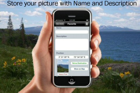
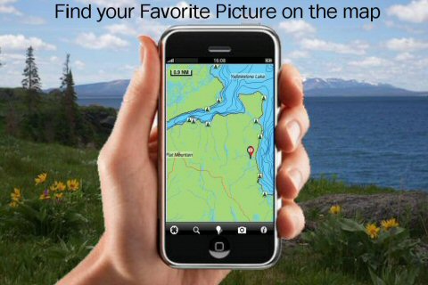
· Insert Unlimited Markers near favorite places on the map
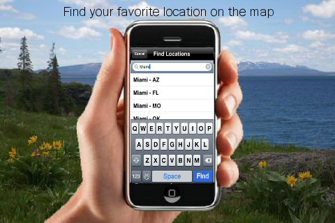
· Search your Favorite points directly
· Zoom, Rotate and Pan fast just by a finger touch
· Navigate and see your GPS position on the map
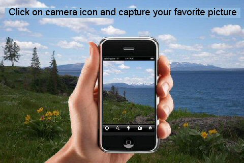
· Geo-Tagged photo management
· Set On/Off Elevation Contours if you feel data is cluttering
What's New in This Release:
· GPS Info Page
· Faster Names Search
What's New in 2.5.1:
· Minor bug Fixed
What's New in 2.5:
· Fully compatible to 4.0
· Improved GPS management in low signal conditions
· Added direction angle information when navigating toward a destination
Like it? Share with your friends!
If you got an error while installing Themes, Software or Games, please, read FAQ.
Supported operating systems:
Apple iOS 10.x (iPad), Apple iOS 10.x (iPhone), Apple iOS 11.x (iPad), Apple iOS 12.x (iPad), Apple iOS 12.x (iPhone), Apple iOS 4.0.x (iPhone), Apple iOS 4.0.x (iPod Touch), Apple iOS 4.2.x (iPad), Apple iOS 4.2.x (iPhone), Apple iOS 4.2.x (iPod Touch), Apple iOS 4.3.x (iPad), Apple iOS 4.3.x (iPhone), Apple iOS 4.3.x (iPod Touch), Apple iOS 5.0 (iPad), Apple iOS 5.0 (iPhone), Apple iOS 5.0 (iPod Touch), Apple iOS 6.0 (iPad), Apple iOS 6.0 (iPhone), Apple iOS 6.0 (iPod Touch), Apple iOS 7.0 (iPad), Apple iOS 7.0 (iPhone), Apple iOS 7.0 (iPod Touch), Apple iOS 8.x (iPad), Apple iOS 8.x (iPhone), Apple iOS 8.x (iPod Touch), Apple iOS 9.x (iPad), Apple iOS 9.x (iPhone), Apple iOS 9.x (iPod Touch), Apple iPhone OS 3.1.x, Apple iPhone OS 3.1.x (iPod Touch), Apple iPhone OS 3.2.x (iPad)
Similar Software:
Berlin Multimedia Travel Guide in German Berlin Multimedia Travel Guide in German. This FREE VERSION allows you to discover how useful and userfriendly the Guide is. It contains around 100 points of interest instead of 750, 1 AUDIO GUIDE instead of 3 and 2 zoom levels instead of 4. Through this version, you may obtain the COMPLETE VERSION
New Orleans Map and Walking Tours New Orleans Map and Walking Tours - No need to hop on a tour bus or join a group; now you can explore all the best attractions on your own, at your own pace, and at a cost that is only a fraction of what you would normally pay for a guided tour
New York Subway 10 for iPad New York Subway 10 - The “New York Subway” application is a superb geographically based map and route planner for the New York public transport systems
North Cascades National Park - Standard North Cascades National Park - Standard - Continues in the tradition of offering depth of information and functionality across expected places all over the world, exploring the map you get maximum details obtaining detailed information of each object on the map
Miami Travel Guide - Lonely Planet Comprehensive maps ensure you're never lost in this vast cultural playground; detailed history, culture and language chapters give you an essential entree to local life and independent, in-depth research means you'll never need to second guess
Mexico City Map Offline Mexico City Map Offline - This will be perfect when you are traveling and you don't have internet connection. This Offline Maps is not a replacement of Google Maps. It is used when you don't have internet connection and want to use maps
Sydney Walking Tours and Map Sydney Walking Tours and Map - No need to hop on a tour bus or join a group; now you can explore all the best attractions on your own, at your own pace, and at a cost that is only a fraction of what you would normally pay for a guided tour
Washington Metro for iPad by Zuti Washington Metro for iPad by Zuti - The new Washington Metro 10 map makes it easy to travel in and around the city using the WMATA Metro, MARC and VME systems. Also included are the Potomac river taxi routes and the DC Circulator bus routes
Other Software by developer «Flytomap»:
Marine: Alaska South East HD - GPS Map Navigator Marine: Alaska South East HD - GPS Map Navigator - FlytoMap provides complete, quick and easy to use map applications for navigation for iPad. Continues in the tradition of offering depth of information and functionality across expected places all over the world, exploring the map you get maximum details obtaining detailed information of every object on the map
Marine: Nord Adriatico (Adriatic North) - GPS Map Navigator Marine: Nord Adriatico (Adriatic North) - GPS Map Navigator - FlytoMap provides Marine applications with complete, quick and easy to use map Interface for navigation for iPhone, exploring the map you get maximum details obtaining complete information of each point on the map
Madagaskar HD - GPS Map Navigator Madagaskar HD - GPS Map Navigator - FlytoMap provides complete, quick and easy to use map applications for navigation for iPad. Continues in the tradition of offering depth of information and functionality across expected places all over the world, exploring the map you get maximum details obtaining detailed information of every object on the map
Cape Cod National Seashore - GPS Map Navigator Cape Cod National Seashore - GPS Map Navigator - Continues in the tradition of offering depth of information and functionality across expected places all over the world, exploring the map you get maximum details obtaining detailed information of each object on the map
Cyclades - GPS Map Navigator Cyclades - GPS Map Navigator - FlytoMap provides complete, quick and easy to use map applications for navigation for iPhone. Continues in the tradition of offering depth of information and functionality across expected places all over the world, exploring the map you get maximum details obtaining detailed information of every object on the map
Azores Islands - GPS Map Navigator Azores Islands - GPS Map Navigator. FlytoMap provides complete, quick and easy to use map applications for navigation for iPhone. Continues in the tradition of offering depth of information and functionality across expected places all over the world, exploring the map you get maximum details obtaining detailed information of every object on the map
Isle Royal National Park - GPS Map Navigator Isle Royal National Park - GPS Map Navigator - Continues in the tradition of offering depth of information and functionality across expected places all over the world, exploring the map you get maximum details obtaining detailed information of each object on the map
Saguaro National Park - GPS Map Navigator Saguaro National Park - GPS Map Navigator - FlytoMap provides complete, quick and easy to use map applications for navigation for iPhone. Continues in the tradition of offering depth of information and functionality across expected places all over the world, exploring the map you get maximum details obtaining detailed information of every object on the map
Marine: Perth HD - GPS Map Navigator Marine: Perth HD - GPS Map Navigator - FlytoMap provides complete, quick and easy to use map applications for navigation for iPad. Continues in the tradition of offering depth of information and functionality across expected places all over the world, exploring the map you get maximum details obtaining detailed information of every object on the map


 - GPS Map Navigator")


