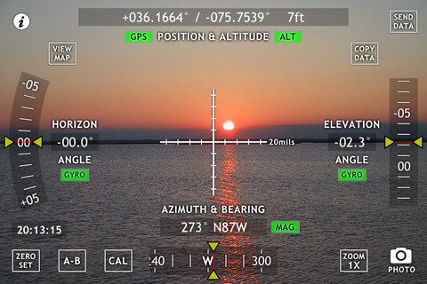
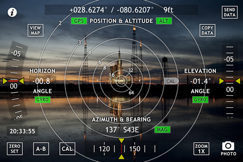
Theodolite Pro Based on a centuries-old astronomical instrument, Theodolite is a cool multi-function augmented reality app for the iPhone that serves as a compass, GPS, map, zoom camera, rangefinder, and two-axis inclinometer. Theodolite overlays real time information about position, altitude, bearing, and horizontal/vertical inclination on the iPhone’s live camera image, like an electronic viewfinder. Uses are endless, and the app is great for hiking, boating, hunting, golf, sports, sightseeing, navigation, and finding your way around. The app is used extensively by surveyors, geologists, architects, engineers, military personnel, and search and rescue workers around the world.
Theodolite lets you take camera images and screenshots directly from the app, with 2X and 4X digital zoom options. You can choose to stamp geographical data and custom notes directly on the saved image for later reference. View your current position on the built in map view, with standard, satellite, and hybrid modes.
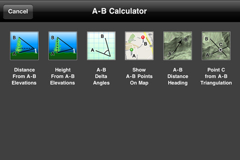
The flagship of the Theodolite series, Pro includes features for serious users like a reference angle mode, an A-B calculator for height, distance, heading, position, triangulation, and relative angles, e-mail export with KML data, system-wide clipboard integration, percent grade display, mil compass readout, optical rangefinders (including a mil-based reticle), military grid reference system (MGRS) coordinates, universal transverse Mercator (UTM) coordinates, and four latitude/longitude formats.
Theodolite works on any iPhone. GPS functionality requires an iPhone 3G, 3GS, or 4. Compass functionality requires an iPhone 3GS or 4. On iPhone 4, compass and inclinometer data are augmented by the gyro, and the application uses high res artwork for the Retina Display.
What's New in This Release:
· Ability to share map markers and A-B points with other users of Theodolite Pro and Theodolite HD via SMS text messages and e-mail. To access this feature, tap any marker shown on the built-in map, and then tap the "Share" button on the marker's popup. Data shared from normal markers includes position and marker name. Data shared from A or B points include position, altitude, azimuth, elevation angle, and horizon angle. This allows users to share A-B measurement points for distributed and team calculations.
What's New in 2.6.1:
· Fixed bug in storage of map markers and added rangefinder lens specs for the iPhone 4S.
What's New in 2.6:
· Combined distance/height calculation in A-B calculator. Data logging feature with clipboard integration and e-mail export.
What's New in 2.5:
· Location search/lookup capability on map panel
· Ability to add and manage position markers on map
· A/B markers now shown on map automatically
· A/B map markers now include bearing indicator arrows
· Display of A/B/C bearing and triangulation lines on map
· Added button to quickly recenter map to current location
· Improved accuracy of A/B/C triangulation calculations
· Display of floating A/B markers on screen dials for bearing, horizon, and elevation angles
· Revised reticle artwork
· New fullscreen wire style reticle
· Added 0.1 sec screen display precision to coordinates in DMS mode
· Improved screenshot rendering process
What's New in 2.2:
· Geo-tag metadata (position, altitude, bearing, datum, compass reference, user note) now saved in image EXIF headers when taking photos and screenshots. New icon artwork
Like it? Share with your friends!
If you got an error while installing Themes, Software or Games, please, read FAQ.
Supported operating systems:
Apple iOS 10.x (iPhone), Apple iOS 12.x (iPhone), Apple iOS 4.2.x (iPhone), Apple iOS 4.2.x (iPod Touch), Apple iOS 4.3.x (iPhone), Apple iOS 4.3.x (iPod Touch), Apple iOS 5.0 (iPhone), Apple iOS 5.0 (iPod Touch), Apple iOS 6.0 (iPhone), Apple iOS 6.0 (iPod Touch), Apple iOS 7.0 (iPhone), Apple iOS 7.0 (iPod Touch), Apple iOS 8.x (iPhone), Apple iOS 8.x (iPod Touch), Apple iOS 9.x (iPhone), Apple iOS 9.x (iPod Touch)
Similar Software:
Brighton Map Offline Brighton Map Offline - This will be perfect when you are traveling and you don't have internet connection. This Offline Maps is not a replacement of Google Maps. It is used when you don't have internet connection and want to use maps
Knoxville (TN,USA) Map Offline Knoxville (TN,USA) Map Offline - This will be perfect when you are traveling and you don't have internet connection. This Offline Maps is not a replacement of Google Maps. It is used when you don't have internet connection and want to use maps
CroTune - Croatian Tourist Navigator (iPhone) CroTune - Croatian Tourist Navigator (iPhone) - Crotune - Croatian Tourist Navigator is a free tourist helper application. Crotune database contains more than 2000 tourist subjects and events located in Croatia. A perfect companion for your holiday. The database is continuously updated with new information, geo-data, price lists and events
Red Panic Button (iPhone) Red Panic Button (iPhone) - When you are in trouble press the Red Panic Button! You just have to set a panic number or mail address and the mobile phone will send a message which contains your address and location, determined using the fine GPS based or coarse GSM based coordinates
Sequoia - Kings National Park - GPS Map Navigator Sequoia - Kings National Park - GPS Map Navigator - Continues in the tradition of offering depth of information and functionality across expected places all over the world, exploring the map you get maximum details obtaining detailed information of each object on the map
Abbotsford Map Offline Abbotsford Map Offline - This will be perfect when you are traveling and you don't have internet connection. This Offline Maps is not a replacement of Google Maps. It is used when you don't have internet connection and want to use maps
Herbert Hoover National Historic Site - GPS Map Navigator Herbert Hoover National Historic Site - GPS Map Navigator - Continues in the tradition of offering depth of information and functionality across expected places all over the world, exploring the map you get maximum details obtaining detailed information of each object on the map
Graz Maps Offline Graz Maps Offline - This will be perfect when you are traveling and you don't have internet connection. This Offline Maps is not a replacement of Google Maps. It is used when you don't have internet connection and want to use maps
CoPilot Live Premium Australia + NZ CoPilot Live Premium Australia + NZ - CoPilot Live Premium is the full-featured voice-guided sat nav application to get you where you need to go, by the way that suits you best
NAVIGON Australia NAVIGON Australia - With the NAVIGON MobileNavigator you can transform your iPhone into a fully functional mobile navigation system that is every bit as good as the multi-award-winning personal navigation devices from NAVIGON in terms of its user-friendliness and features
Other Software by developer «Hunter Research and Technology»:
Theodolite Based on a centuries-old astronomical instrument, Theodolite is a cool multi-function augmented reality app for the iPhone that serves as a compass, GPS, map, zoom camera, rangefinder, and two-axis inclinometer
Theodolite Basic Based on a centuries-old astronomical instrument, Theodolite Basic is a cool multi-function augmented reality app for the iPhone that serves as a compass, GPS, map, zoom camera, and two-axis inclinometer
gMeter gMeter is an application that turns the iPhone and iPod Touch into a vehicle performance computer. By using the onboard accelerometer in these devices, gMeter can measure forward and lateral g forces and use this data to compute acceleration, velocity, distance traveled, and engine power
Wx for iPad Wx for iPad The venerable U.S. weather app Wx is now available for iPad! Wx displays current conditions, forecasts, alerts, and radar for U.S. locations using high fidelity XML data from the U.S. National Weather Service
ODAT Tracker This application tracks deals from backcountry.com's "one deal at a time" (ODAT) sites
gyroLens gyroLens - Ever have problems taking that perfect photo? Can't frame a straight shot? Need help getting a level image? Use gyroCam! This full-featured camera app has a killer new feature: it automatically levels photos in real time, while shooting
Flow (iPhone) Flow (iPhone) is a handy fluid dynamics app for the iPhone and iPod Touch. The software implements 1D compressible flow equations, normal and oblique shock relations, laminar and turbulent flat plate boundary layer development, standard atmosphere modeling, and the gas properties of air at sea level
Butterfly Collection Butterfly Collection - Roam the world from your iPhone or iPod Touch to explore diverse species of butterflies and moths. Butterfly Collection showcases 240 members of the fascinating and beautiful order of insect known as Lepidoptera (ancient Greek for "scale wing"), using photographs of actual insects
greenMeter GreenMeter is an application for the iPhone and iPod Touch that computes your vehicle's power and fuel usage characteristics and evaluates your driving to increase efficiency, reduce fuel consumption and cost, and lower your environmental impact


 Map Offline")
")
")


")

