Platforms: iPhone, iPad, iPod Touch, Apple iPhone OS
Categories: Science & Education
Upload date: 14 Aug 11
Developer: VITO Technology
License: Commercial
Price: 2.99 $
Downloads: 53
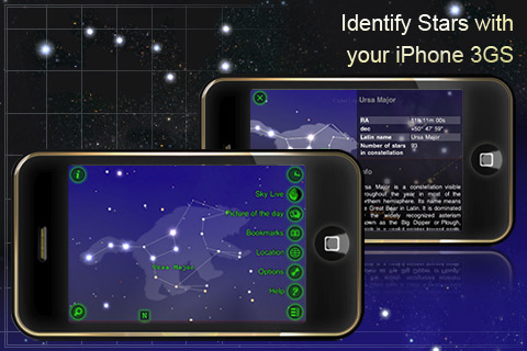
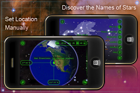
Star Walk for iPhone - Star Walk enables you to point your iPhone at the sky and see what stars, constellations, and satellites you are looking at in real-time.
Please note, you will need a 3GS/4/4th gen iPod Touch for motion tracking, otherwise this app will be just a beautiful info-packed time-sensitive interactive star atlas that allows you to set your location manually to give you the most accurate picture.
· Augmented Reality
· Star Spotter - real time motion tracking tells you what stars are above you in the sky;
· Satellites Tracking - never miss ISS flying over your head again;
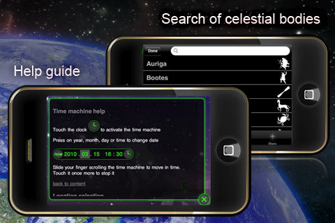
· Time Machine - see what the sky looks like at any moment in the past or future;
· Calendar of Celestial Events: plan stargazing without leaving your favorite app.
· Picture of the Day - stunning pictures from deep space;
· Night Mode - preserve your dark vision to see more stars;
· Search - wondering where Jupiter is right now? Arrow will guide you to it;
· Big Screen - connect a second display to view the sky on a big screen.
· AirPrint, Moon Phases, Info, View from any location, TelRad, Sharing, Bookmarks, and more!
What's New in This Release:
· Now the StarWalk database includes up to 8000 artificial satellites such as
· New video tutorial for quick overview of main features and how-to instructions
What's New in 5.2.2:
· Fixed Star Walk Server problem connected with sharing features.
· Improved Search function behavior.
· Fixed some mistakes in different localizations.
· Fixed Earth lighting in Home Location window.
· Improved AR mode turning on animation.
· Fixed Moon lighting inaccuracy.
· Fixed occasional crashes during PODs browsing.
Like it? Share with your friends!
If you got an error while installing Themes, Software or Games, please, read FAQ.
Supported operating systems:
Apple iOS 10.x (iPad), Apple iOS 10.x (iPhone), Apple iOS 11.x (iPad), Apple iOS 12.x (iPad), Apple iOS 12.x (iPhone), Apple iOS 4.0.x (iPhone), Apple iOS 4.0.x (iPod Touch), Apple iOS 4.2.x (iPad), Apple iOS 4.2.x (iPhone), Apple iOS 4.2.x (iPod Touch), Apple iOS 4.3.x (iPad), Apple iOS 4.3.x (iPhone), Apple iOS 4.3.x (iPod Touch), Apple iOS 5.0 (iPad), Apple iOS 5.0 (iPhone), Apple iOS 5.0 (iPod Touch), Apple iOS 6.0 (iPad), Apple iOS 6.0 (iPhone), Apple iOS 6.0 (iPod Touch), Apple iOS 7.0 (iPad), Apple iOS 7.0 (iPhone), Apple iOS 7.0 (iPod Touch), Apple iOS 8.x (iPad), Apple iOS 8.x (iPhone), Apple iOS 8.x (iPod Touch), Apple iOS 9.x (iPad), Apple iOS 9.x (iPhone), Apple iOS 9.x (iPod Touch), Apple iPhone OS 3.1.x, Apple iPhone OS 3.1.x (iPod Touch), Apple iPhone OS 3.2.x (iPad)
Similar Software:
Astronomy - Oxford Dictionary Astronomy - Oxford Dictionary - Edited by renowned author and broadcaster Ian Ridpath, with the help of over 20 expert contributors, the second edition of this highly popular dictionary contains over 4,200 up-to-date entries on all aspects of astronomy
Cassini Cassini - NASA’s Cassini mission launched in 1997 and has been exploring the Saturnian system from orbit since July 2004. Currently in its second extended mission, Cassini continues to unravel mysteries about Saturn and its atmosphere, rings and magnetosphere, and its moons, particularly Titan and the icy satellites
Phases for iPad Phases for iPad View the moon phase, age, illumination, moonrise, moonset and much more for any date or time. Choose a city from our massive database of over 20,000 cities or use your iPad's GPS to show even more accurate information
SkyView Free SkyView - Where will the Sun rise and set today? Is there a Full Moon tonight? Where is the Big Dipper? What is the name of that bright star? What are some fun facts about these objects?
SkyView Free is a powerful and easy-to-use application that answers these questions and more
SkyView SkyView - Where will the Sun rise and set today? Is there a Full Moon tonight? Where is the constellation Orion? Am I looking at a bright star or a planet? What are some fun facts about these objects?
SkyView is a powerful and easy-to-use application that answers these questions and more
LunaSolCal for iPhone/iPad LunaSolCal for iPhone/iPad calculates times of sunrise, sunset, moonrise and moonset for your location at any given date
SkySafari 3 SkySafari 3 - SkySafari is a chart star app for all astronomy enthusiasts. It includes a comprehensive database of 120,000 stars and 220 of the most known star clusters, nebulae and galaxies.
In addition, the application displays the Solar System's planets along with their moons, as well as the most important asteroids and comets
Sky Above Sky Above - Sky Above is an iOS app which tells you where stars, constellations, planets and satellites are above you in the sky. The application also uses augmented reality to show the real sky using the device's camera. Just hold your iPhone or iPad up to the sky and the names of the sky objects will be overlayed on the camera display
Solar Walk Solar Walk - Let's find out more about our neighboring planets in the Universe, play around with them determining the speed of circulation, time, choosing a particular planet to become the center of the Universe, seeing the moons of Saturn, Jupiter, Mars and Urano. The 3D model in the Solar Walk app is the exact reproduction of the real solar system
HubbleSite HubbleSite, the online home of NASA’s Hubble Space Telescope, invites you to help choose the world’s most popular Hubble images. Get wallpapers, Hubble facts, and more.
Hubble’s vast collection of images awaits your critical and discerning eye
Other Software by developer «VITO Technology»:
Map of Suriname Map of Suriname - A map of the Suriname by VITO Technology. Good for intercity travels with SmartMap.
SmartMap is a mobile device application which uses vector and raster maps. It is compatible with any NMEA protocol GPS receiver (Compact Flash socket, serial port, BlueTooth or sleeve)
Map of Vermont (US State) Map of Vermont (US State) - A map of the Vermont by VITO Technology. Good for intercity travels with SmartMap.
SmartMap is a mobile device application which uses vector and raster maps. It is compatible with any NMEA protocol GPS receiver (Compact Flash socket, serial port, BlueTooth or sleeve)
Map of Nebraska (US State) Map of Nebraska (US State) - A map of the Nebraska by VITO Technology. Good for intercity travels with SmartMap.
SmartMap is a mobile device application which uses vector and raster maps. It is compatible with any NMEA protocol GPS receiver (Compact Flash socket, serial port, BlueTooth or sleeve)
Map of Pakistan Map of Pakistan - A map of Pakistan. Good for intercity travels with SmartMap.
Layers include:
Towns
Settlements
Airports
Roads
Railroads
Rivers
Inland water
Administrative borders
International borders
Trees
Map scale is 1:1 million.
Good for use with any version of SmartMap. SmartMap can be purchased here
Map of Trinidad and Tobago Map of Trinidad and Tobago - A map of Trinidad and Tobago. Good for intercity travels with SmartMap.
Layers include:
Towns
Settlements
Airports
Roads
Railroads
Rivers
Inland water
Administrative borders
International borders
Trees
Map scale is 1:1 million.
Good for use with any version of SmartMap
Map of Sweden Map of Sweden - Set of 2 maps of Sweden accompanied by a short text description.
SWEDEN (NORTH)
SWEDEN (SOUTH)
Good for intercity travels with SmartMap
Map of South Carolina (US State) Map of South Carolina (US State) - A map of the South Carolina by VITO Technology. Good for intercity travels with SmartMap.
SmartMap is a mobile device application which uses vector and raster maps. It is compatible with any NMEA protocol GPS receiver (Compact Flash socket, serial port, BlueTooth or sleeve)
Map of Singapore Map of Singapore -
A map of Singapore. Good for travels with SmartMap.
Layers include:
Towns
Settlements
Airports
Roads
Railroads
Rivers
Inland water
Administrative borders
International borders
Trees
Map scale is 1:1 million.
Good for use with any version of SmartMap. SmartMap can be purchased here
Map of Texas (US State) Map of Texas (US State) - A map of the Texas by VITO Technology. Good for intercity travels with SmartMap.
SmartMap is a mobile device application which uses vector and raster maps. It is compatible with any NMEA protocol GPS receiver (Compact Flash socket, serial port, BlueTooth or sleeve)
Map of Qatar Map of Qatar - A map of Qatar, divided into 9 smaller territories for the ease of use.
ASH SHAMAL
AL GHUWAYRIYAH
AL KHAWR
AL JUMAYLIYAH
UMM SALAL
AD DAWHAH
AR RAYYAN
AL-WAKRAH
JARAYAN AL BATNAH
Good for intercity travels with SmartMap


")
")


")

")
