Platforms: iPhone, iPad, iPod Touch, Apple iPhone OS
Categories: Travel & Navigation
Upload date: 16 May 11
Developer: Visual IT
License: Commercial
Price: 2.99 $
Downloads: 32
Boston Subway by Zuti - The new Boston Subway map makes it easy to travel in and around the city using the MBTA Subway, MBTA Commuter Rail, MBTA Boats, and Massport shuttle buses. Unlike old fashioned schematic style maps this product contains a geographically accurate central area showing major streets, parks and places of interest etc, allowing the user to easily get their bearings.
MAP
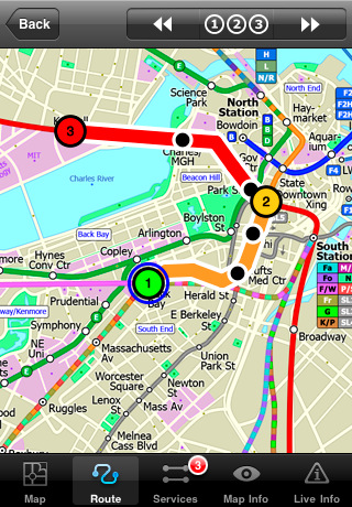
The map is hand drawn by Visual IT and provides a unique geographically based view of Boston with many places of interest drawn directly on the background so you can easily get your bearings when traveling around the city. You can also use your inbuilt GPS to accurately locate and track yourself within the city centre and see the nearest transportation stop and distance to it. This is the only public transportation route planner with this ability.
Tap on the map for location information, use the inbuilt search feature or choose from a list of locations. Places of interest, museums, hotels, parks, restaurant, shops, hospitals, streets, etc, are also included. The route planner will automatically suggest the nearest station to any place of interest you select.
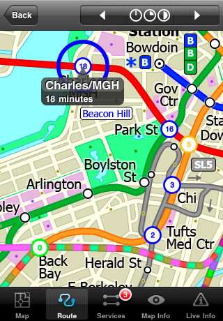
MINUTE MAP
Another great feature is the “Minute Map” option which allows you to see the travel times from a start point to all other locations on the map. This is a unique way to view the topology of a city and gauge traveling times.
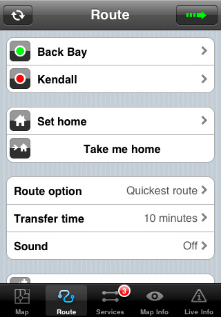
ROUTING
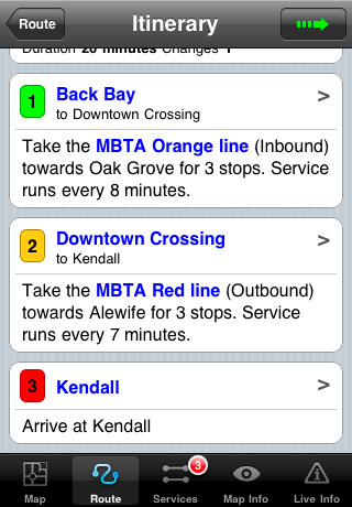
The application does not require an internet connection and will always be available to display a clear and detailed view of the city transport systems, plus list and animate the optimum route for your journey. This product provides the fastest route calculations of any mobile routing application (virtually instantaneous) using actual published journey times with the ability to select the quickest route or the route with the least changes.
LIVE INFO
When an internet connection is available, optional "Live Information" on the current state of the transport services can be viewed, allowing you to plan your journeys in advance and avoid any potential delays. Unique to this application is the ability to turn off services that are out of action and automatically calculate an alternative route.
· Full offline map and routing, no internet connection required.
· Colourful clear custom drawn geographically accurate mapping.
· Animates the route and allows tracking of the journey using GPS
· Instantly see the route of any transport service drawn on the map.
· Save and recall favorite and recent journeys.
· Take me home feature.
· Unique "Minute Map" feature allows quick view of all journey times from a start location.
· Services can be turned on or off, routing round problems.
· Works on iPhone or iPod and in landscape or portrait mode.
· GPS location and tracking.
· Streets, Places of interest etc built into the application.
· Access to live service information.
Like it? Share with your friends!
If you got an error while installing Themes, Software or Games, please, read FAQ.
Supported operating systems:
Apple iOS 10.x (iPad), Apple iOS 10.x (iPhone), Apple iOS 11.x (iPad), Apple iOS 12.x (iPad), Apple iOS 12.x (iPhone), Apple iOS 4.0.x (iPhone), Apple iOS 4.0.x (iPod Touch), Apple iOS 4.2.x (iPad), Apple iOS 4.2.x (iPhone), Apple iOS 4.2.x (iPod Touch), Apple iOS 4.3.x (iPad), Apple iOS 4.3.x (iPhone), Apple iOS 4.3.x (iPod Touch), Apple iOS 5.0 (iPad), Apple iOS 5.0 (iPhone), Apple iOS 5.0 (iPod Touch), Apple iOS 6.0 (iPad), Apple iOS 6.0 (iPhone), Apple iOS 6.0 (iPod Touch), Apple iOS 7.0 (iPad), Apple iOS 7.0 (iPhone), Apple iOS 7.0 (iPod Touch), Apple iOS 8.x (iPad), Apple iOS 8.x (iPhone), Apple iOS 8.x (iPod Touch), Apple iOS 9.x (iPad), Apple iOS 9.x (iPhone), Apple iOS 9.x (iPod Touch), Apple iPhone OS 3.1.x, Apple iPhone OS 3.1.x (iPod Touch), Apple iPhone OS 3.2.x (iPad)
Similar Software:
Chicago Maps Chicago Maps - This super-handy app lets you download publicly available maps and store them on your iPhone or iPod Touch. You can download the maps when you have fast wifi connection - and then use any time in the future without delay. Transit Train and Street maps, as well as tourist guides to help you around the city
Southwest Airlines Southwest Airlines - Traveling with Southwest Airlines is now even more convenient with our first iPhone app. Make reservations, check in for flights, and access your Rapid Rewards account directly from your iPhone. Plus, our iPhone app has DING! functionality built in, giving you instant access to exclusive, limited-time-only air fare deals
Australia's Best Places Australia's Best Places - This is the definitive guide to all the best places & authentic experiences across Australia from the outback to the beach, from its casually confident cities to its ancient indigenous culture.
It offers insider tips on how to engage with Australia’s remarkable landscapes, its idiosyncratic locals & its utterly bizarre wildlife
Charlotte(North Carolina) World Travel Charlotte(North Carolina) World Travel - Map with locate me function makes you free to move.
Background reading always accompanies you on your trip
Bremerhaven World Travel Bremerhaven World Travel - map with locate me function makes you free to move.
Background reading always accompanies you on your trip
Denver Daytrips Denver Daytrips - Visiting Denver and have a few hours, a day or more, and want to see the city, easily visit nearby towns and do some high-country exploring? Download this Denver Daytrips app, stick your iPhone in your pocket and head out. Or, grab your iPad and get going
MetrO (iPhone/iPad) MetrO (iPhone/iPad) - MetrO helps you find your way in the public transportation in more than 400 cities around the world.
One application for all your trips: download the cities you need and search your route by subway, bus, railway, tram ... (depending on cities). NO network connection is required after you have installed the cities
Miami Maps Miami Maps - software that helps you download and store the travel maps and plans you need. This super-handy app lets you download publicly available maps and store them on your iPhone or iPod Touch. You can download the maps when you have fast wifi connection - and then use any time in the future without delay
Tokyo Metro for iPad by Zuti Tokyo Metro for iPad by Zuti - Tokyo Metro map makes it easy to travel in and around the city using the Toei Subway, JR East routes (within the Tokyo Suburban area), Shinkansen routes, Streetcars, some important private lines and Tokyo Cruise lines
London Tube for iPad by Zuti London Tube 10 is a superb geographically based map and route planner for the London Underground, Overground, Docklands Light Railway (DLR), Croydon Tramlink and London Airport Express services
Other Software by developer «Visual IT»:
Tube Moscow (Palm OS) Tube Moscow (Palm OS) - An award winning and highly acclaimed Palm OS application that guides you around the complex metro system of Moscow. An essential addition to your Palm device for locals and tourists alike.
Tube's features include:
A detailed clear colour map of the Moscow metro system fully scrollable.
Quick find station utility
Tube 2 Boston Pro (Palm OS) Tube 2 Boston Pro (Palm OS) - This map package for Tube 2 consists of a fully scrollable detailed map of the Boston metro & commuter rail system and linked street maps of central Boston.
Plan journeys on the metro system, list details of the quickest routes and see a superb animated display of your journey tracking around the system map
London Mini A-Z for iPad London Mini A-Z for iPad - This clear and colourful high quality map is a digital rendition of the famous "London A-Z Mini Atlas" and covers an area from West Hendon in the North West to Grove Park in the South East. Add this application to you iPad and you will have instant access to all 352 pages of the London Mini A-Z printed map
Berlin Metro by Zuti Berlin Metro by Zuti - The new Berlin Metro map makes it easy to travel in and around the city using the Metro (U-Bahn) Suburban Rail (S-Bahn) and Tram (MetroTram and Straßenbahn) systems
Hong Kong Subway by Zuti Hong Kong Subway by Zuti - The new Hong Kong Metro 10 map makes it easy to travel in and around the city using the MTR transit railway, MTR light rail, MTR Airport Express, Trams, Cable Car and Ferry services
Tube 2 Baltimore (UIQ3) Tube 2 Baltimore (UIQ3) - This map package for Tube 2 consists of a fully scrollable detailed map of the Baltimore metro & rail system.
Plan journeys on this system, list details of the quickest routes and see a superb animated display of your journey tracking around the system map
Beijing Subway for iPad by Zuti Beijing Subway for iPad by Zuti - Beijing Metro map makes it easy to travel in and around the city using the Beijing metro system and also includes the S2 rail line to the Great Wall at Badaling
Tube Rome (Series 60) Tube Rome (Series 60) - Our highly acclaimed Tube application that guides you around the metro & rail system of Rome is now available for your Series 60 Symbian powered phone. An essential addition to your phone for locals and tourists alike.
· A detailed clear colour map of the Rome metro & rail system fully scrollable.
· Quick find station utility
London Tube by Zuti London Tube by Zuti - "London Tube 10" is a superb geographically based map and route planner for the London Underground, Overground, Docklands Light Railway (DLR), Croydon Tramlink and London Airport Express services. This is one in a worldwide series of Zuti maps from Visual IT who have been producing public transportation maps for mobile devices for many years
Tube 2 Tokyo (UIQ3) Tube 2 Tokyo (UIQ3) - This map package for Tube 2 consists of a fully scrollable detailed map of the Tokyo city subway & JR rail system


 World Travel")


")


")
")


")

")

")