San Francisco Metro 10 for iPad - The new San Francisco Metro 10 application makes it easy to travel in and around the city using the Metro (BART), Streetcar, Light Rail(MUNI), Ferry and Presidio shuttle bus services.
Unlike old fashioned schematic style maps this product contains a geographically accurate central area showing major streets, parks and places of interest etc, allowing the user to easily get their bearings.
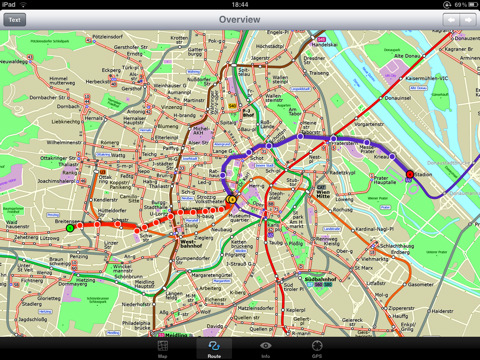
MAP
The map is hand drawn by Visual IT and provides a unique geographically based view of San Francisco with many places of interest drawn directly on the background so you can easily get your bearings when traveling around the city. You can also use your inbuilt GPS to accurately locate and track yourself within the city centre and see the nearest transportation stop and distance to it. This is the only pubic transportation route planner with this ability.
Tap on the map for location information, use the inbuilt search feature or choose from a list of locations. Places of interest, museums, hotels, parks, restaurant, shops, hospitals, streets, etc, are also included. The route planner will automatically suggest the nearest station to any place of interest you select.
MINUTE MAP
Another great feature is the “Minute Map” option which allows you to see the travel times from a start point to all other locations on the map. This is a unique way to view the topology of a city and gauge traveling times.
ROUTING
The application does not require an internet connection and will always be available to display a clear and detailed view of the city transport systems, plus list and animate the optimum route for your journey. This product provides the fastest route calculations of any mobile routing application (virtually instantaneous) using actual published journey times with the ability to select the quickest route or the route with the least changes. If you like to preplan your routes just hit the “Add to favourites” button to save your chosen route. If you would like to see where a particular services runs and stops, just select that service from the list and select “Show on map”.
LIVE INFO
When an internet connection is available, optional "Live Information" on the current state of the transport services can be viewed (and automatically saved for future reference) allowing you to plan your journeys in advance and avoid any potential delays. Unique to this application is the ability to turn off services that are out of action and automatically calculate an alternative route.
· Full offline map and routing, no internet connection required.
· Colourful clear custom drawn geographically accurate mapping.
· Unique “Minute Map” feature allows quick view of all journey times from a start location.
· Services can be viewed on the map and turned on/off, routing around problems.
· GPS location and tracking.
· Streets, Places of interest etc built into the application.
· Favourite routes can be stored and recalled.
· Access to live service information.
What's New in This Release:
· Minor bug fix
Like it? Share with your friends!
If you got an error while installing Themes, Software or Games, please, read FAQ.
Supported operating systems:
Apple iOS 10.x (iPad), Apple iOS 11.x (iPad), Apple iOS 12.x (iPad), Apple iOS 4.2.x (iPad), Apple iOS 4.3.x (iPad), Apple iOS 5.0 (iPad), Apple iOS 6.0 (iPad), Apple iOS 7.0 (iPad), Apple iOS 8.x (iPad), Apple iOS 9.x (iPad), Apple iPhone OS 3.2.x (iPad)
Similar Software:
Plane Finder 3D for iPhone/iPad Plane Finder 3D for iPhone/iPad - Plane Finder 3D is a flight tracker that shows live air traffic in beautiful 3D.
With simple touch controls you can pan and zoom to fly around the planes, and can even get on board a plane for a captain's eye view from the cockpit
Dearborn(Michigan) World Travel Dearborn(Michigan) World Travel - Map with locate me function makes you free to move.
Background reading always accompanies you on your trip
Raved for iPhone Raved for iPhone - Raved allows you to discover great places suggested by friends, including restaurants, bars, night clubs, shops, hotels and more. In addition, it enables you to share your personal recommendations with your social circle
Tokyo Metro for iPad by Zuti Tokyo Metro for iPad by Zuti - Tokyo Metro map makes it easy to travel in and around the city using the Toei Subway, JR East routes (within the Tokyo Suburban area), Shinkansen routes, Streetcars, some important private lines and Tokyo Cruise lines
TransitGuru Maryland MTA The only transit app that combines with offline schedule, system maps, multiple transit types (train or bus) or agencies for single metro area, alarm to wake you up when arrival, and integration with Yelp and Map
Cold War Walking Tour in Berlin Cold War Walking Tour in Berlin - No place on Earth stood at the heart of the 20th Century conflict between the ideological poles of Communism and Capitalism like Berlin. A divided city in a divided Germany in a divided Europe in a divided world
HomeAway HomeAway - Download the FREE HomeAway app to browse nearly 230,000 worldwide vacation rental property listings! The map and sorting tools make it easy to search for a vacation rental. Each listing features vibrant, full-screen property photos and the ability to inquire directly from your mobile phone. Once you've found one you like, you can share it with your social networks
North America - iGO primo Lite North America - iGO primo Lite - iGO primo Lite is a free route planner and map viewer built upon the experienced iGO Engine employed by GPS navigation devices all over the world. The software uses accurate offline maps which can be used anywhere. This way you don't have to worry about losing your internet connection, and you avoid unnecessary data traffic costs
Priceline.com: Hotels, Flights & Rental Cars Priceline.com: Hotels, Flights & Rental Cars - Power up priceline.com's Hotel Negotiator app and let the Priceline Negotiator, William Shatner, find you last-minute Name Your Own Price hotel rooms that you can book at savings of up to 50%.
· Choose a city and see multiple winning hotel bids for the hotel star levels and parts of the city you want
Hotels by Orbitz Hotels by Orbitz - Simple, powerful, fast and fun. The free Orbitz app designed just for the iPad lets you shop and book hotels effortlessly -- on the couch or on the go. It delivers a vast selection of hotels, powerful comparison tools, and secure booking in just 3 taps. And you can do it all within the vivid, friendly interface of the iPad, from the comfort of your ..
Other Software by developer «Visual IT»:
Tube San Francisco Pro for Palm OS Tube San Francisco Pro for Palm OS - This map package for Tube 2 consists of a fully scrollable detailed map of the San Francisco metro & rail systems and linked high quality street maps of central San Francisco
TUBE 2 Paris (Blackberry) TUBE 2 Paris (Blackberry)
Tube 2 Paris
Transform your Blackberry into a fully scrollable detailed map of the Paris Metro system.
Plan journeys on the Paris Metro system, have the quickest routes to hand, with all the details you need including line changes, platform directions and accurate journey times
Tube 2 Chicago (Palm OS) Tube 2 Chicago (Palm OS) - This map package for Tube 2 consists of a fully scrollable detailed map of the Chicago metro & commuter rail system.
It includes the rapid transport system of subway and elevated lines, in addition to the many commuter rail lines. The map also indicates how the Amtrak intercity routes intersect with the cities transport network
Vienna Metro by Zuti Vienna Metro by Zuti - This Zuti application contains a visually unique map of Vienna's transport systems and a superb animated journey planner to help you get around the Metro (U-Bahn), Suburban Rail (S-Bahn) and Tram (Stragenbahn)
Tube 2 San Francisco Pro (UIQ3) Tube 2 San Francisco Pro (UIQ3) - This map package for Tube 2 consists of fully scrollable detailed maps of the San Francisco metro & rail systems and linked high quality street maps of central San Francisco
Washington Metro for iPad by Zuti The new Washington Metro 10 map makes it easy to travel in and around the city using the WMATA Metro, MARC and VME systems. Also included are the Potomac river taxi routes and the DC Circulator bus routes
Tube Sydney (Series 60) Tube Sydney (Series 60) - Our highly acclaimed Tube application that guides you around the rail system of Sydney is now available for your Series 60 Symbian powered phone. An essential addition to your phone for locals and tourists alike.
· A detailed clear colour map of the Sydney rail system fully scrollable.
· Quick find station utility
Paris Metro for iPad by Zuti Paris Metro 10 - This Zuti application contains a visually unique map of the Paris transport system and a superb animated journey planner to help you get around the Metro, RER, SNCF, Tram, Tvm, and Vogueo services. Now revised and updated to include a larger geographic area which covers more of the outlying areas surrounding Paris
Rome Metro for iPad by Zuti Rome Metro for iPad by Zuti - The Zuti Rome Metro application is a superb geographically based map and route planner for the Metro, Tram, Urban and Regional rail systems. Unlike old fashioned schematic style maps this product contains a geographically accurate central area showing major streets, parks and places of interest etc, allowing the user to easily get their bearings
Rough Guides Map Amsterdam Rough Guides Map Amsterdam... These guides are a series of fantastic interactive maps.
Produced in conjunction with the premier travel publisher Rough Guides.
Discover and explore Amsterdam using full colour interactive linked maps, in this simple to use PDA version of The Rough Guides Amsterdam


 World Travel")


")
")

")

")


