Platforms: iPhone, iPad, iPod Touch, Apple iPhone OS
Categories: Travel & Navigation
Upload date: 10 Oct 13
Developer: Trimble Navigation Limited
License: Commercial
Price: 4.99 $
Downloads: 34
Trimble GPS Hunt Pro - Cabela's Recon Hunt is the first mobile navigation application built solely for hunters. With Recon Hunt, you can find hunting spots on detailed maps, track wildlife, take trophy photos and backtrack home. Recon Hunt also tracks other essentials as well: weather forecasts, sun and moon phases, trip stats and ballistics information. Our power saver technology monitors how you use the app in order to preserve battery power. Plus, Recon Hunt works in remote places without the need of data and cellular signals.
GO ANYWHERE
• Recon Hunt uses the GPS built into your iPhone to track your location with GPS satellites. No data or phone signal is needed to see your current location or to mark points.
• View unlimited topographic maps in the United States and Canada. Topo maps are 1:24K scale in the Lower 48, 1:63K in Alaska, and 1:50K in Canada.
• Consult street maps, terrain maps, and satellite photos for more info.
• Store up to 500MB of map quads on your iPhone for offline viewing and fast load times in the field.
STAY FOUND
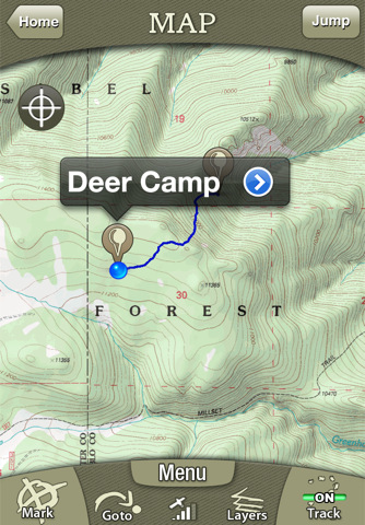
• Follow your track on seamless maps. Zoom in, zoom out. Know where you are at all times.
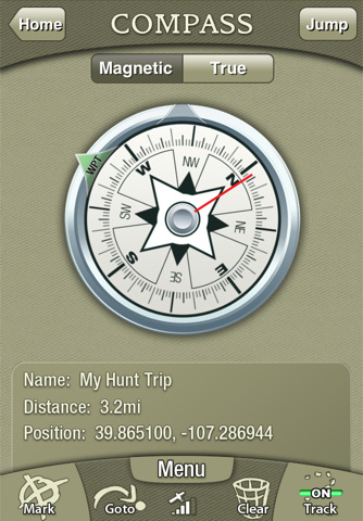
• Navigate with the digital compass. Choose between: Magnetic North and True North. (Note: Magnetic Compass only works on iPhone 3GS and 4)
• Use the Goto feature to navigate from your current location to a saved or manually entered coordinate.
COLLECT DATA
• Mark waypoints of your favorite (or secret) spots like a hunting blind, treestand, game trails or where you parked your truck.
• Record unlimited tracks. See where and how far you have traveled.
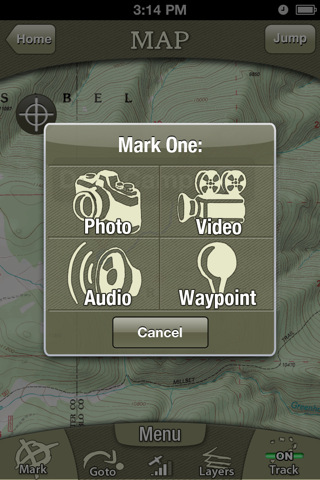
• Capture photos and videos (3GS and 4 only). The Recon Hunt app geotags your media to an exact location on a map.
• Record bugling elk, gobbling wild turkeys or other sounds with the audio recorder.
• See 15+ trip stats, including mileage, speed, elevation, direction, elevation gain/loss, and GPS position.
PLAN & PREPARE
• View Sun and Moon phases by date and location.
• Read the five-day weather forecast. See the current humidity, heat index, dew point, wind chill, wind speed and direction.
MADE FOR HUNTERS
• Get exclusive in-app deals and coupons from Cabela's.
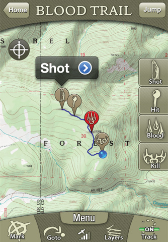
• Turn on Blood Trailing to track blood spots after the shot. Also, measure distances from shot location to hit and recovery spots.
• Disable beeps and noises in the app.
• See ballistics details and graphs for 200+ pistol and rifle cartridges.
• Save precious battery power. Recon Hunt carefully manages battery life based on how you use it.
• Enter the shooting range for your weapon and see the kill zone from your current location.
Notes: Continued use of GPS running in the background can dramatically decrease battery life. Recon Hunt is designed and optimized for the iPhone 4, 3GS, and 3G. The 1st generation models lack a GPS chip required to run the application.
What's New in This Release:
· Ability to purchase Mega Offline Maps.
· Track accuracy fixed in map screen.
· Miscellaneous bug fixes.
Like it? Share with your friends!
If you got an error while installing Themes, Software or Games, please, read FAQ.
Supported operating systems:
Apple iOS 10.x (iPad), Apple iOS 10.x (iPhone), Apple iOS 11.x (iPad), Apple iOS 12.x (iPad), Apple iOS 12.x (iPhone), Apple iOS 5.0 (iPad), Apple iOS 5.0 (iPhone), Apple iOS 5.0 (iPod Touch), Apple iOS 6.0 (iPad), Apple iOS 6.0 (iPhone), Apple iOS 6.0 (iPod Touch), Apple iOS 7.0 (iPad), Apple iOS 7.0 (iPhone), Apple iOS 7.0 (iPod Touch), Apple iOS 8.x (iPad), Apple iOS 8.x (iPhone), Apple iOS 8.x (iPod Touch), Apple iOS 9.x (iPad), Apple iOS 9.x (iPhone), Apple iOS 9.x (iPod Touch)
Similar Software:
Garmin UK & Ireland Garmin UK & Ireland - Download Garmin StreetPilot Onboard UK & Ireland and give your iPhone the best in GPS navigation... with free camera alerts, photoReal junction views, 3D buildings, and more
China Navigation China Navigation - China Navigation is a professional Car, Bike and Pedestrian navigation system. This system is not only for Car navigation, but also for pedestrian.
· 2D and 3D navigation mode and map.
· The speed is very fast.
· Using vector map which is small size and can zoom in any level
· Elegant operations
Monti Sibillini National Park - GPS Map Navigator Monti Sibillini National Park - GPS Map Navigator - FlytoMap provides complete, quick and easy to use map applications for navigation for iPhone. Continues in the tradition of offering depth of information and functionality across expected places all over the world, exploring the map you get maximum details obtaining detailed information of every object on the map
Donana National Park - GPS Map Navigator Donana National Park - GPS Map Navigator - FlytoMap provides complete, quick and easy to use map applications for navigation for iPhone. Continues in the tradition of offering depth of information and functionality across expected places all over the world, exploring the map you get maximum details obtaining detailed information of every object on the map
Gaudalupe - GPS Map Navigator Gaudalupe - GPS Map Navigator - FlytoMap provides complete, quick and easy to use map applications for navigation for iPhone. Continues in the tradition of offering depth of information and functionality across expected places all over the world, exploring the map you get maximum details obtaining detailed information of every object on the map
Speed Limit Notifier Speed Limit Notifier - Are you afraid your loved one is speeding when you lend him/her your car? This is your perfect solution, the application will notify you via email every time someone goes above the specified speed. GPS is required
GPS Tuner Lite (iPhone) GPS Tuner Lite features GROUNDBREAKING off-road navigation software specifically designed for the iPhone. As opposed to traditional car navigation software that plans your route based on a road network, GPS Tuner gives you the ability to navigate where the roads end
Big Bend National Park - GPS Map Navigator Big Bend National Park - GPS Map Navigator - Continues in the tradition of offering depth of information and functionality across expected places all over the world, exploring the map you get maximum details obtaining detailed information of each object on the map
Pensacola Maps Offline Pensacola Maps Offline - This will be perfect when you are traveling and you don't have internet connection. This Offline Maps is not a replacement of Google Maps. It is used when you don't have internet connection and want to use maps
Trinidad & Tobago - GPS Map Navigator Trinidad & Tobago - GPS Map Navigator - FlytoMap provides complete, quick and easy to use map applications for navigation. Continues in the tradition of offering depth of information and functionality across expected places all over the world, exploring the map you get maximum details obtaining detailed information of every object on the map
Other Software by developer «Trimble Navigation Limited»:
AllSport GPS LE (iPhone) AllSport GPS LE - Easy to use yet delivering power and outstanding value, AllSport GPS LE - a free version of the popular AllSport GPS fitness application - transforms your iPhone into a full-featured workout tracker and GPS-enabled trainer for road cycling, mountain biking, running, walking, and other sports and fitness activities
AllSport GPS FREE Track workouts--runs, rides, walks & more. Map routes. Burn calories. Reach your fitness goals faster with AllSport GPS FREE. Track workouts--runs, walks, bike rides and other sports--on a map. View 25 heart-pounding stats as you sweat: time, speed, calories, distance
Backpacker GPS Trails Backpacker brings the outdoors straight to the reader's doorstep, inspiring and enabling them to go more places and enjoy nature more often. The authority on active adventure, Backpacker is the world's first GPS-enabled magazine and website, and the only outdoor media whose editors and network of map contributors personally map the hiking trails they publish
AllSport GPS (iPhone) AllSport GPS - Easier to use and delivering more value and power than ever, AllSport GPS transforms your iPhone into a full-featured workout tracker and GPS-enabled trainer for road cycling, mountain biking, running, walking, and other sports and fitness activities.
Tracking workouts on your iPhone is as easy as Start, Sweat, Stop
Backpacker GPS Trails Lite Backpacker GPS Trails Lite - Record hiking trails, backpacking trips, and camping adventures with Backpacker GPS Trails Lite. View maps, navigate with GPS and digital compass, take photos, and backtrack to the trailhead. GPS Trails Lite works in remote places like national parks, wilderness areas, and backcountry spots without relying on data and cell signals
Cabela's Recon Hunt Cabela's Recon Hunt is the first mobile navigation application built solely for hunters. With Recon Hunt, you can find hunting spots on detailed maps, track wildlife, take trophy photos and backtrack home. Recon Hunt also tracks other essentials as well: weather forecasts, sun and moon phases, trip stats and ballistics information
Geocache Navigator (Nokia) Provides hours of entertainment by combining the technology in your phone with one of the fastest-growing international hide and seek games - geocaching (also known as "GPS treasure hunt"). By using your phone's GPS and built-in Internet, Geocache Navigator creates a seamless and exciting experience


")


")


")


")