Great Britain Rail for iPad by Zuti - The new Great Britain Rail map makes it easy to travel in and around the country using the rail services. This application contains a geographically accurate map of the whole of Great Britain allowing you to easily view the route of any journey. The routing and map are contained within the application and no internet connection is required to use these features.
MAP
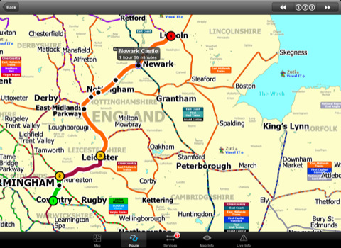
The map is hand drawn by Visual IT and provides a unique geographically based view of the Great Britain rail system. You can also use your inbuilt GPS to accurately locate and track yourself and see the nearest transportation stop and distance to it. This is the only rail transportation route planner with this ability. Tap on the map for location information, use the inbuilt search feature or choose from a list of locations.
MINUTE MAP
Another unique feature is the “Minute Map” option which allows you to see the travel times from a start point to all other locations on the map. This is a great way to view the topology of the country and gauge traveling times.
ROUTING
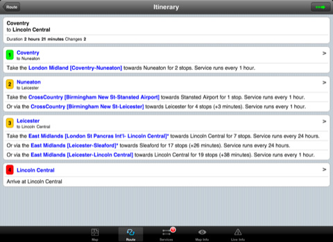
The application does not require an internet connection for routing and will always be available to display a clear and detailed view of the various rail operating company systems, plus list and animate the optimum route for your journey. This product provides the fastest route calculations of any mobile routing application using actual published journey times with the ability to select the quickest route or the route with the least changes.
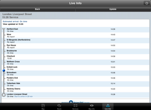
LIVE INFO
When an internet connection is available the user can check train arrivals and departures with live data supplied by National Rail Enquiries. Also shown is the estimated current real time position of the train for any of the listed services.
· The only rail app with a rail map.
· Full offline map and routing, works anywhere, no internet connection required.
· Designed for the first time visitor and experienced commuter.
· Simple, fast and intuitive to use.
· Colourful clear custom drawn geographically accurate mapping.
· Animates the route and allows tracking of the journey using GPS.
· Instantly see the route of any transport service drawn on the map.
· Save and recall favourite and recent journeys.
· One touch take me home feature.
· Unique "Minute Map" feature allows quick view of all journey times from a start location.
· Services can be turned on or off, routing round problems.
· Works on any iPad with iOS 3.2 or above.
· GPS location and tracking.
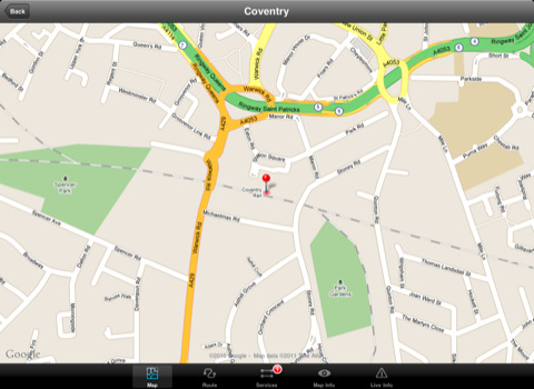
· View station locations on a Google map (internet required).
· View Live train departures and arrivals (internet required, live data supplied by National Rail Enquiries).
Like it? Share with your friends!
If you got an error while installing Themes, Software or Games, please, read FAQ.
Supported operating systems:
Apple iOS 10.x (iPad), Apple iOS 11.x (iPad), Apple iOS 12.x (iPad), Apple iOS 4.2.x (iPad), Apple iOS 4.3.x (iPad), Apple iOS 5.0 (iPad), Apple iOS 6.0 (iPad), Apple iOS 7.0 (iPad), Apple iOS 8.x (iPad), Apple iOS 9.x (iPad), Apple iPhone OS 3.2.x (iPad)
Similar Software:
Washington Metro for iPad by Zuti The new Washington Metro 10 map makes it easy to travel in and around the city using the WMATA Metro, MARC and VME systems. Also included are the Potomac river taxi routes and the DC Circulator bus routes
London Bus Free London Bus Free - The new Zuti London Bus map has finally arrived, making it easy to travel by bus anywhere in central London. This clear and colourful map covers a detailed street level area of 6 miles by 4 miles and includes over 1300 bus stops and 189 bus routes
Houston Maps Houston Maps - software that helps you download and store the travel maps and plans you need. This super-handy app lets you download publicly available maps and store them on your iPhone or iPod Touch. You can download the maps when you have fast wifi connection - and then use any time in the future without delay
TripAdvisor for iPhone/iPad TripAdvisor for iPhone/iPad - TripAdvisor is your one stop for all your travel needs. It includes reviews and advice on hotels, restaurants, resorts, flights and more
Priceline Priceline - Power up priceline.com's Hotel Negotiator app and let the Priceline Negotiator, William Shatner, find you last-minute Name Your Own Price hotel rooms that you can book at savings of up to 50%.
· Choose a city and see multiple winning hotel bids for the hotel star levels and parts of the city you want
Hotels by Orbitz Hotels by Orbitz - Simple, powerful, fast and fun. The free Orbitz app designed just for the iPad lets you shop and book hotels effortlessly -- on the couch or on the go. It delivers a vast selection of hotels, powerful comparison tools, and secure booking in just 3 taps. And you can do it all within the vivid, friendly interface of the iPad, from the comfort of your ..
Detroit Maps Detroit Maps software that helps you download and store the travel maps and plans you need. This super-handy app lets you download publicly available maps and store them on your iPhone or iPod Touch. You can download the maps when you have fast wifi connection - and then use any time in the future without delay
Rome Metro by Zuti Rome Metro by Zuti - The "Rome Metro" application is a superb geographically based map and route planner for the Rome Metro, Tram, Urban and Regional rail systems. This application is one in a worldwide series of Zuti maps from Visual IT who have been producing public transportation maps for mobile devices for many years
Beijing Subway for iPad by Zuti Beijing Subway for iPad by Zuti - Beijing Metro map makes it easy to travel in and around the city using the Beijing metro system and also includes the S2 rail line to the Great Wall at Badaling
Trip Journal Free (iPhone) Trip Journal is the #1 Travel Application with the best trip tracking, recording, documenting and sharing features currently available for the iPhone.
Trip Journal allows you to document vacation experiences and share them with your friends and family
Other Software by developer «Visual IT»:
Tube 2 Chicago Pro (UIQ3) Tube 2 Chicago Pro (UIQ3) - This map package for Tube 2 consists of a fully scrollable detailed map of the Chicago metro & commuter rail system and linked street maps of central Chicago.
Plan journeys on the metro system, list details of the quickest routes and see a superb animated display of your journey tracking around the system map
Tube Madrid (Series 60) Tube Madrid (Series 60) - Our highly acclaimed Tube application that guides you around the complex metro system of Madrid is now available for your Series 60 Symbian powered phone. An essential addition to your phone for locals and tourists alike.
· A detailed clear colour map of the Madrid metro system fully scrollable.
· Quick find station utility
Tube 2 Boston Pro (UIQ3) Tube 2 Boston Pro (UIQ3) - This map package for Tube 2 consists of a fully scrollable detailed map of the Boston metro & commuter rail system and linked street maps of central Boston.
Plan journeys on the metro system, list details of the quickest routes and see a superb animated display of your journey tracking around the system map
Tube 2 London Geo Tube 2 London Geo - This superb map package for Tube 2 is the ideal map for anyone who needs to get around London using the underground system and would like to know just exactly where they are.
The map geographically accurately locates the central London stations, overlaid onto a street map. Now you can easily see how these stations fit into the real world
Tube 2 San Francisco (UIQ) Tube 2 San Francisco (UIQ) - This map package for Tube 2 consists of a fully scrollable detailed map of the San Francisco metro & rail systems.
The maps in this package cover the BART, SCVTA & Caltrain systems plus the Municipal Metro, Municipal Historic Street Car and Cable Car systems in central SF
The Pad (V3) The Pad (V3) - The Pad... This simple yet invaluable application is the fastest way to write and draw on a Windows Mobile Professional / Pocket PC PDA or phone
Tube 2 Berlin (Palm OS) Tube 2 Berlin (Palm OS) - This map package for Tube 2 consists of a fully scrollable detailed map of the Berlin Metro (U-Bahn/S-Bahn).
Plan journeys on this system, list details of the quickest routes and see a superb animated display of your journey tracking around the system map.
Berlin is the capital and largest city in Germany
Tube London (2009 Edition) Tube London (2009 Edition) - Tube London
The ideal map for the traveller who needs to get around London using the underground system and would like to know just exactly where they are.
The map geographically locates all the central stations, making it much more informative than the official topological map
Beijing Subway for iPad by Zuti Beijing Subway for iPad by Zuti - Beijing Metro map makes it easy to travel in and around the city using the Beijing metro system and also includes the S2 rail line to the Great Wall at Badaling
London Visitors A-Z for iPad London Visitors A-Z for iPad - The London Visitors A-Z map of central London is designed especially for the tourist


")
")
")
")

")
")
")
")
