Symbian OS | Pocket PC | Smartphone | Android | BlackBerry | Apple iPhone OS | Java | Mobile Gaming | Linux | Palm | Win CE | Tablet  
     

Free Mobile Software, Themes, Games, Apps for PDA and Smartphones

     
Search by Device
My Device

  
Last Viewed Apps
TTPod
Search by Category
Business & Profession
Databases
Dictionary & Translator
Entertainment
Finance
Games
Healthcare & Medicine
Internet & Communications
Multimedia & Graphics
Organisation & Productivity
Programming & Development
Reading
Science & Education
System Utilities
Themes & Wallpapers & Skins
Travel & Navigation
Geocaching
GPS
Guides
Maps
Measuring & Compass
Travel Planning
Weather
Worldtime
More
Search by Platform
Android
Apple iPhone OS
iPad
iPhone
iPod Touch
BlackBerry
Java
Linux
Maemo Nokia Internet Tablet
MeeGO
Sharp Zaurus
Mobile Gaming
Nintendo DS
Playstation 3
Playstation Portable
Wii
Xbox 360
Palm OS
Symbian OS
Series 60
Series 80
Series 90
UIQ
Tablet PC
Windows CE.NET
Windows Mobile Pocket PC
Windows Mobile Smartphone


Achivx Partner
 
 
FlyToMap GPS HD - All in One


FlyToMap GPS HD - All in One
Version: 2.5.1

Platforms: iPad, Apple iPhone OS


Categories: Travel & Navigation

Upload date: 22 Feb 11

Developer: Flytomap

License: Commercial

Price: 0.99 $

Downloads: 54


Download Trial of FlyToMap GPS HD - All in One 


Rating: 0.0/5 (Total votes: 0)


FlytoMap provides complete, quick and easy to use map applications for navigation for iPad. Continues in the tradition of offering depth of information and functionality across expected places all over the world, exploring the map you get maximum details obtaining detailed information of every object on the map.

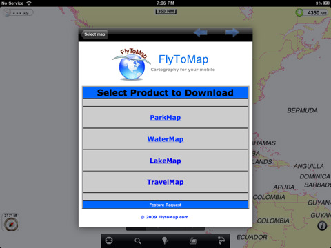
You can now buy one Application and you will be allowed to download any needed map for FREE:
- All USA Marine charts (US All, East, West, Great Lakes, Major Rivers,Florida, Texas, California, etc.)
- more than 100 US Parks and Forests
- 20 major EU parks (shortly will be 100)
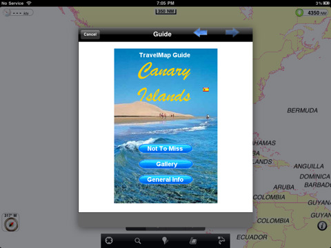
- most famous WORLD holiday areas and islands (Caribbean, Seychelles, Mauritius, Maldives, Canary Islands, Azores, Oslo Fjord, etc.)
- Lake Maps for Minnesota, Michigan, Massachusetts, Wisconsin....

FlytoMap processes different types of maps for navigation for different categories:

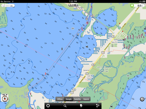
WATER MAPS (Marine):
Water map navigator is the new ‘Marine Navigator for iPhone’ contains embedded Electronic Nautical Charts (ENC) from NOAA compressed to a large coverage. You can now download the application and transform your iPhone in a chart plotter with best NOAA, ENC S57 cartography; which includes Anchoring areas, Fishing areas, restriction areas, obstructions, rocks, Buoys, Beacons, Lights, Depth contours with Values display on map, Spot Soundings and more. The only marine app available in the market with such huge information. Every effort is made to be as accurate as possible when presenting information for every destination.

PARK MAPS:
Park map applications are extremely advanced contains embedded electronic charts with all information collected from the National Park Service and local sources. The maps contain all multiple trails (Hiking, biking, Stairway trails, Bicycle trails, Equestrian trails etc.,) and Point of interests (POI) like Campgrounds, Eating places, Ranger Stations, Picnic areas, Boat/Canoe launching, Parking areas etc., which are provided depending on the relevant park areas they exist.

LAKE MAPS:
We offer high quality lake maps with detailed information and important features compressed to assure the larger coverage in USA region. Lake maps contain most important DNR lakes with detailed ‘Depth Contours, Boat Ramps, Fishing spots etc. Also includes Trails, Roads and Railways information.

TRAVEL MAPS:
These Maps treat you mostly with information of both Marine and terrain correspondingly. These are the most preferable Maps to travel especially for fascinating recreational voyages, map focus the best Beach spots along the Coast line, Major ports, Sailing, Fishing, Picnic areas, Parks, Hiking, Biking, Clubs, restaurants, Famous Hotels, Museums, Shopping areas, and much more.

· Use Latitudes and Longitudes to go to your favorite places
· Insert the target/destination ‘Waypoint’ and see in real time your speed, distance and direction to destination
· Insert Unlimited Markers near favorite places on the map
· Search your Favorite points directly
· Zoom, Rotate and Pan fast just by a finger touch
· Navigate and see your GPS position on the map
· Geo-Tagged photo management
· Set On/Off Elevation Contours if you feel data is cluttering

What's New in This Release:

New areas available:
· Lakes: Lake Champlain, Lake Mead, Lake Of the Woods, Lake Okeechobee, Lake Powell, Lake Tahoe, Lake Texoma, Lake Winnebago, Leech Lake, Mille Lacs Lake
· Marine: Netherlands, New Zealand
· Parks: Nymboi-Binderay National Park, Parque del Retiro-Madrid, Parque Eduardo VII-Lisbon, Ralambshovsparken-Stockholm, Sam Rayburn Reservoir, Schönbrunner Schloßpark-Vienna, St Stephens Green-Dublin, Stockholm, Tete d’or Park-Lyon, Toledo Bend Reservoir, Villa Borghese-Rome, Vondelpark-Amsterdam, Warandeparc-Brussels, Wellington National Park, Namadgi National Park, Villa Reale-Milan


Like it? Share with your friends!

If you got an error while installing Themes, Software or Games, please, read FAQ.
 

Supported operating systems: Apple iOS 10.x (iPad), Apple iOS 11.x (iPad), Apple iOS 12.x (iPad), Apple iOS 4.2.x (iPad), Apple iOS 4.3.x (iPad), Apple iOS 5.0 (iPad), Apple iOS 6.0 (iPad), Apple iOS 7.0 (iPad), Apple iOS 8.x (iPad), Apple iOS 9.x (iPad), Apple iPhone OS 3.2.x (iPad)
 
Similar Software:

Hong Kong Walking Tours and MapHong Kong Walking Tours and Map
Hong Kong Walking Tours and Map - No need to hop on a tour bus or join a group; now you can explore all the best attractions on your own, at your own pace, and at a cost that is only a fraction of what you would normally pay for a guided tour
Acapulco Map and Walking ToursAcapulco Map and Walking Tours
Acapulco Map and Walking Tours - This Lite version of the walking tours application comes with a detailed and fully functional city map to assist you explore the city and locate sights. City map functions in this app include: street name and business (restaurants, cafes, etc
Theodolite BasicTheodolite Basic
Based on a centuries-old astronomical instrument, Theodolite Basic is a cool multi-function augmented reality app for the iPhone that serves as a compass, GPS, map, zoom camera, and two-axis inclinometer
Tilburg - Breda (Netherland) Map OfflineTilburg - Breda (Netherland) Map Offline
Tilburg - Breda (Netherland) Map Offline - This will be perfect when you are traveling and you don't have internet connection. This Offline Maps is not a replacement of Google Maps. It is used when you don't have internet connection and want to use maps
Fugawi iMap: Sweden Entire CountryFugawi iMap: Sweden Entire Country
Fugawi iMap: Sweden Entire Country - Fugawi iMap: Sweden Entire Country is a Topo Map application of Sweden for iPhone. It is great for going off-road and into the back country. For those who prefer a lower Price, the App is also sold in 4 regions of Sweden. Features: => All of Sweden Included..
Mesa Maps OfflineMesa Maps Offline
Mesa Maps Offline - This will be perfect when you are traveling and you don't have internet connection. This Offline Maps is not a replacement of Google Maps. It is used when you don't have internet connection and want to use maps
Chisinau Map and Walking ToursChisinau Map and Walking Tours
Chisinau Map and Walking Tours - No need to hop on a tour bus or join a group; now you can explore all the best attractions on your own, at your own pace, and at a cost that is only a fraction of what you would normally pay for a guided tour
Charlotte Map OfflineCharlotte Map Offline
Charlotte Map Offline - This will be perfect when you are traveling and you don't have internet connection. This Offline Maps is not a replacement of Google Maps. It is used when you don't have internet connection and want to use maps
Grand Rapids (MI, USA) Maps OfflineGrand Rapids (MI, USA) Maps Offline
Grand Rapids (MI, USA) Maps Offline - This will be perfect when you are traveling and you don't have internet connection. This Offline Maps is not a replacement of Google Maps. It is used when you don't have internet connection and want to use maps
Marine: Chesapeake Bay - GPS Map NavigatorMarine: Chesapeake Bay - GPS Map Navigator
Marine: Chesapeake Bay - GPS Map Navigator - Continues in the tradition of offering depth of information and functionality across expected places all over the world, exploring the map you get maximum details obtaining detailed information of each object on the map
 

Other Software by developer «Flytomap»:

Acadia National Park - StandardAcadia National Park - Standard
Acadia National Park - Standard - FlytoMap provides complete, quick and easy to use map applications for navigation for iPhone. Continues in the tradition of offering depth of information and functionality across expected places all over the world, exploring the map you get maximum details obtaining detailed information of every object on the map
Yosemite National Park - StandardYosemite National Park - Standard
Yosemite National Park - Standard - Continues in the tradition of offering depth of information and functionality across expected places all over the world, exploring the map you get maximum details obtaining detailed information of each object on the map
Jamaica - GPS Map NavigatorJamaica - GPS Map Navigator
Jamaica - GPS Map Navigator - FlytoMap provides complete, quick and easy to use map applications for navigation for iPhone. Continues in the tradition of offering depth of information and functionality across expected places all over the world, exploring the map you get maximum details obtaining detailed information of every object on the map
Isola del Giglio - GPS Map NavigatorIsola del Giglio - GPS Map Navigator
Isola del Giglio - GPS Map Navigator - FlytoMap provides complete, quick and easy to use map applications for navigation. Continues in the tradition of offering depth of information and functionality across expected places all over the world, exploring the map you get maximum details obtaining detailed information of every object on the map
Marine: Perth HD - GPS Map NavigatorMarine: Perth HD - GPS Map Navigator
Marine: Perth HD - GPS Map Navigator - FlytoMap provides complete, quick and easy to use map applications for navigation for iPad. Continues in the tradition of offering depth of information and functionality across expected places all over the world, exploring the map you get maximum details obtaining detailed information of every object on the map
Nationalpark Bayerischer Wald - GPS Map NavigatorNationalpark Bayerischer Wald - GPS Map Navigator
Nationalpark Bayerischer Wald - GPS Map Navigator - FlytoMap provides complete, quick and easy to use map applications for navigation for iPhone. Continues in the tradition of offering depth of information and functionality across expected places all over the world, exploring the map you get maximum details obtaining detailed information of every object on the map
Bornholm (Denmark) - GPS Map NavigatorBornholm (Denmark) - GPS Map Navigator
Bornholm (Denmark) - GPS Map Navigator - FlytoMap provides complete, quick and easy to use map applications for navigation for iPhone. Continues in the tradition of offering depth of information and functionality across expected places all over the world, exploring the map you get maximum details obtaining detailed information of every object on the map
Lake Powell - FishingLake Powell - Fishing
Lake Powell - Fishing - Lake Powell is the ultimate recreational spot for millions of visitors having 186 miles length with 1960 miles of shoreline for excellent activities. Lake Powell is well known for activities like Swimming, Boating and Kayaking, Fishing, Scuba diving, Snorkeling, Water skiing and sightseeing. Photographic opportunities around are plentiful
Saguaro National Park - GPS Map NavigatorSaguaro National Park - GPS Map Navigator
Saguaro National Park - GPS Map Navigator - FlytoMap provides complete, quick and easy to use map applications for navigation for iPhone. Continues in the tradition of offering depth of information and functionality across expected places all over the world, exploring the map you get maximum details obtaining detailed information of every object on the map
Marine: Sydney HD - GPS Map NavigatorMarine: Sydney HD - GPS Map Navigator
Marine: Sydney HD - GPS Map Navigator - FlytoMap provides complete, quick and easy to use map applications for navigation for iPad. Continues in the tradition of offering depth of information and functionality across expected places all over the world, exploring the map you get maximum details obtaining detailed information of every object on the map

» show more


Comments on FlyToMap GPS HD - All in One:

Comments not found

Name:


Comment:


Enter text from image below:

Turn on images!


If you noted an error or download link is broken, please, report it via this page or use comments.
 

Please, select device to check if FlyToMap GPS HD - All in One supports it
 
 
© Pantich 2009 - 2025 All rights reserved.